California Condors!!

This is a rare real-time (happened today) post!

As I was driving towards the Grand Canyon North Rim entrance this afternoon I drove through an area that had been burned out in a wildfire in 2006. As I rounded a curve I saw 6 huge black things in the skeletal remains of a tree. At first I thought they might be nests of some kind. As I got a little closer I realized they were birds, and then I saw some vehicles pulled off to the side of the road and a small number of people standing around so I knew it must be something worthwhile.

It turns out they were (relatively rare) California Condors. Their numbers had dwindled down to only a few dozen but efforts have been made to breed them in captivity for release into the wild and there are now several hundred. I thought I had seen one way up in the air in this same area back in 2017 (search “Condor” on the blog homepage, then look for the post titled “Final Day…” posted on 9/14/17). By the time I turned the car around and could find a safe place to get it completely off the road without starting a wildfire in the dry vegetation next to the road, four of them had flown off (there was a woman out in the brush walking slowly towards the tree and that evidently scared most of them off). I saw the last one of the four take off and it was enormous.

Here are the two that were left:

This is the one on the higher branch:

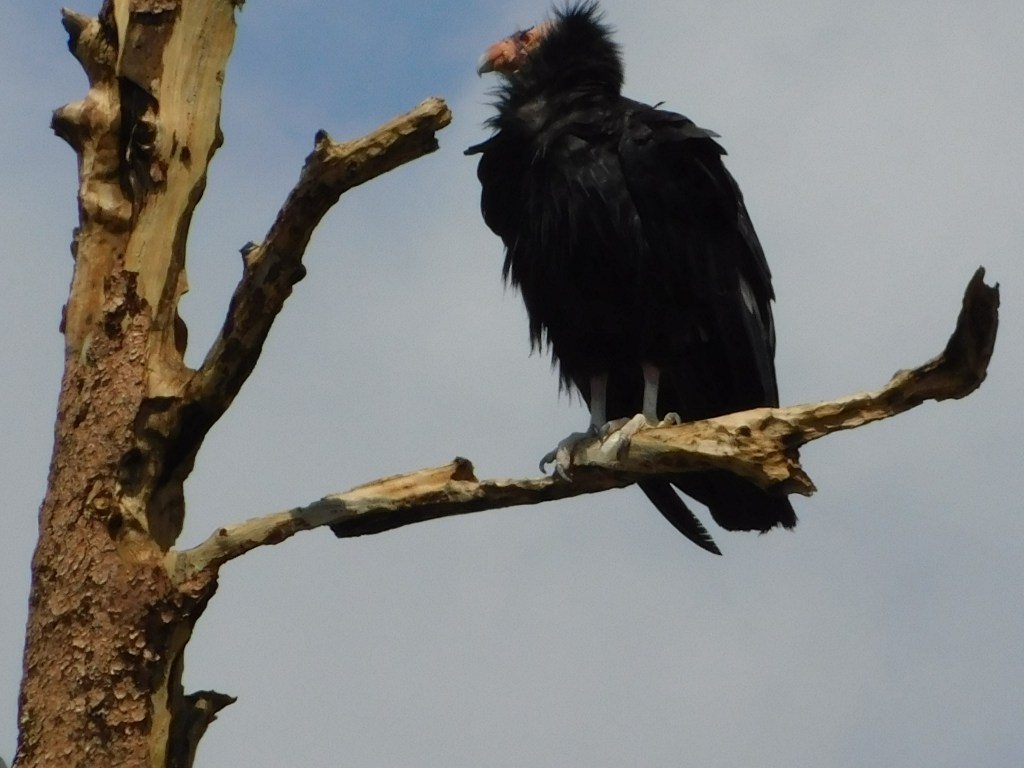
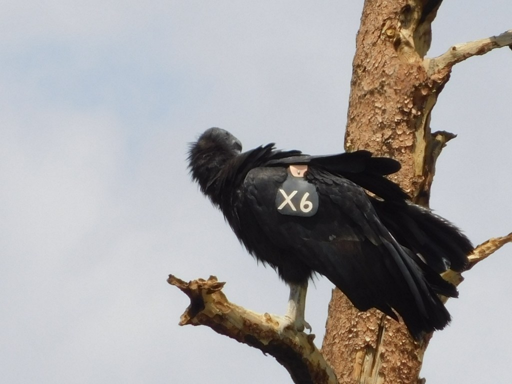
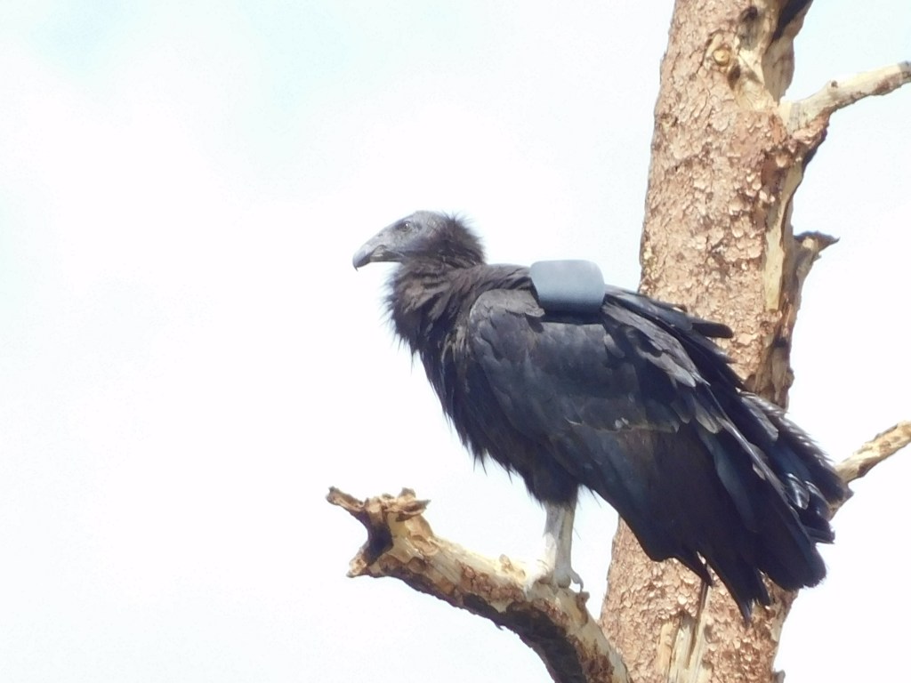
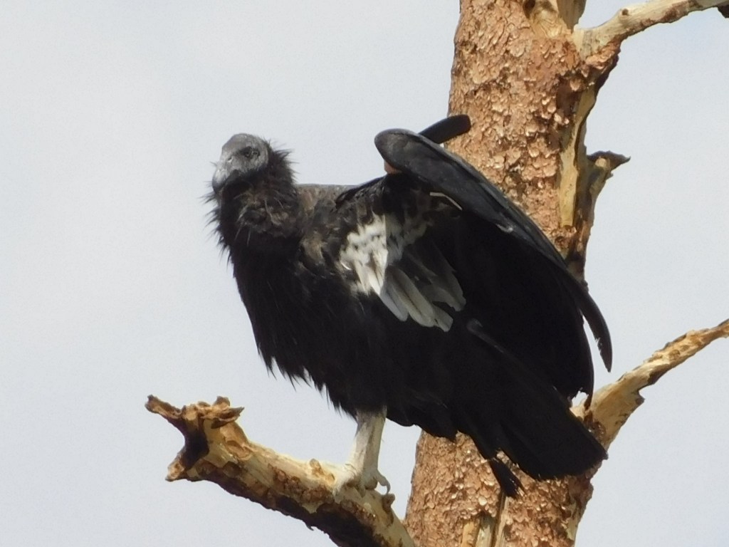
The way I know they are condors is that that have a wing tag which identifies them:

According to the peregrinefund.org website, A9 is an adult male, hatched 5/22/04 at the Birds of Prey Sanctuary in Boise, Idaho. It was released into the wild on 3/1/05 and is one of about 80 which are believed to stay in the Arizona/Utah area, with about 160 more in California and 30 in Baja, Mexico. I’ve seen different numbers on different sites so the current numbers may be higher than that.

According to one of the other observers, one way to tell that it is an adult by sight is that it had a reddish head. The one on the lower branch is just a young tyke – hatched 4/22/18 and released by the same organization on 9/28/19. It is a female, the area around her head is still black (ah, youth…), and her tag number is X6:

From what I have read online an adult condor has a wingspan of between 8 1/2 and 9 1/2 feet, compared with a turkey vulture at 5 feet or a golden eagle at 6 feet. Here is a condor/human picture I found online:

(Photo credit: NPS.gov, photo by Arianna Punzalan)

I was hoping the birds might still be there when I left the Park but they were gone. I will keep a sharp eye out as I go in and out of the Park tomorrow, and may even try again Saturday when I leave Fredonia AZ to drive down to my next stop, south of Phoenix. One of the other people who stopped to look says he sees them here frequently and also gave me the name of another spot nearby where they are often spotted. Depending on the weather tomorrow I may try that location as well. There was more rain here today, though it didn’t affect my brief time in the Park. I will get an early start tomorrow and am staying much closer to the Park. Generally the storms seem to develop in the early to mid-afternoon so I should have lots of opportunities.

My night at the Cody Rodeo

Four years ago, as I traveled through Yellowstone National Park and the surrounding area in northwest Wyoming, I passed through the town of Cody, which is east of the southeast entrance to the Park. Cody bills itself as the “Rodeo Capital of the World” and I decided that day that this was where I wanted to see my first rodeo. I had planned to have a shirt made proclaiming “This IS my first rodeo!” but as with many of my plans it never came to fruition.

During the summer Cody hosts a rodeo every night of the week. As I drive around the western states I see many small towns which have rodeo arenas and host them sporadically, especially on the 4th of July. Lander was going to have one then, too, but I was going to be gone by then. So I booked an Airbnb for the night in a nearby town and headed up to Cody.

The arena itself is a little smaller than a football field. There were two big grandstands on opposite sides and a smaller one in one “corner” (to the extent that ovals have corners). My guess was that there were about 200 people in each of the two main grandstands.

This is a family activity and there were lots of children of various ages. About midway through the event they called all the kids down on to the arena surface for a contest. The crowd loved it. Overall I would say it was a night of wholesome family entertainment. I wish I had walked through the parking lot before it started to see how many state license plates were represented. I know I saw several without taking a formal survey.

I have mixed feelings about the treatment of the animals but from what I read online many of the horses and bulls are bred and trained to “buck” and the apparatus which is used to “aggravate” them isn’t as terrible as I first thought. Rodeos have been around for a very long time and are part of the cowboy culture.

The event lasted a little over two hours, and I stayed for the whole thing. There were a variety of events and there was only one rider who appeared to have been injured, though he ultimately walked off under his own power. For a while, though, you could tell he was in pain.

There was an “emcee” on horseback, in the arena, who kept the audience informed about what was going on and where the riders were from.

I didn’t buy a program but it sounded like some of the participants traveled a considerable distance to compete. I’m sure competing at Cody is a dream for many riders.

At the beginning of the event there were people who rode around carrying flags of the many event sponsors. There was also a prayer, and a young lady rode around with the American flag while the national anthem was played.

And of course there were rodeo clowns, who distract the agitated animals from the people and other animals in the arena until they are “escorted off”.

The guy in the black shirt is blocking the view of the second “clown”. I thought I had taken another shot but evidently I was mistaken.

There were always several people on horseback to “chase” animals out of the arena after their “event” was over. Some went willingly, others had to be chased around a bit. There were also people on foot in the arena, to open the “chute” gate and pick up any debris which came loose (like the rider’s hat), and sometimes they had to scramble up the fence around the arena if the agitated animal came their way.

Enough talk – let’s see some action. Since the event started while the sun was still up I tried getting action shots with my digital camera. Later I switched to taking video clips with my smartphone but I don’t think I can post them on the blog. My nephew Sam tells me I can post them somewhere else (like YouTube, maybe) and then post a link but I haven’t had a chance to try that yet.

The rider was finally ejected and after he had a chance to catch his breath, walked off into the sunset…..

I believe the goal is to stay on for 8 seconds. My Android phone camera used to title each photo with the exact time (including seconds and fractions of seconds) when each photo was taken but my digital camera shows that all the photos in the sequence were taken at 8:14pm so I have no idea how long this rider stayed on. I can get a stopwatch to time the many video clips I shot with my iPhone but I can tell you right now, no one stayed on for very long all night.

There were various roping events, some barrel racing (where riders were timed navigating around strategically placed barrels) and cowboys riding bucking bulls instead of bucking broncos. Other than the period when kids were called down to compete in a contest and another period when the clowns played a little skit to amuse the kids in the crowd, there was something going on all the time.

It was an entertaining evening and I thoroughly enjoyed it. Later in my trip I went to a restaurant for dinner and they had “The Cowboy Channel” (who knew??) on TV, showing a rodeo from Reno, NV – which apparently pays big bucks. They had some awesome riders. And I believe there is a PBR Tour which is sometimes on one of the channels I get on Sling Blue (I’m not sure which one).

I will see if I can’t get some of my video clips to be available my links in a future post.

The road to Cody

Sunday I stayed in to make some more blog posts, organize and backup my photos and watch the NASCAR races from Charlotte in real time (which were on two hours earlier since I am in Mountain Time Zone). Monday I made some local scenic drives in the immediate Lander area and there was nothing remarkable to show (although they were very nice). Tuesday I headed up to Cody WY to attend the rodeo that night. It was my second “overnight” trip and I booked an Airbnb in the little town of Powell, about 30 miles east of Cody.

The drive up was scenic and pleasant. I drove through Wind River Canyon again (if you didn’t look at that post you should. WordPress shows me how many times a post has been viewed and that post, as well as the one of Thermopolis, haven’t had any viewers, although there are a few people who I believe look at everything I post). Here are some more photos from Wind River Canyon taken at a different time of day than the ones I posted previously:

I also spotted some folks rafting down the Wind River, which I learned flows south to north and not the other way around.

I continued north and eventually drove through the little town of Meeteetse, “Where Chiefs Meet”.

The bar’s motto is a takeoff on the town’s motto. In addition to establishments for adults I was pleased to see a facility geared towards underage individuals, giving them a much needed place to go on their own:

It wasn’t open when I was there but inside I could see pinball and other arcade games, a foosball table and other things kids could do for entertainment.

Down at the corner I found this bear, patiently waiting to have his picture taken with someone:

Bear spray not needed in this instance…

I finally arrived in Cody. I posted some photos of smoke from two wildfires I saw, which both turned out to be in nearby Montana, previously. I drove west of town to check out the rodeo grounds:

The rodeo didn’t start until 8pm and you will see lots more photos in subsequent posts.

Next I drove east to check in at my Airbnb since I knew I wouldn’t be getting there until late in the evening. These are some mountains I saw off to my right as I drove towards Powell:

I arrived at my Airbnb and while my hostess was showing me where my room was her young son came in and stood next to her. I said “Hi, I’m John” and he proudly held up four fingers and proclaimed “I’m four”! In subsequent interrogation I learned that he had just turned four in May, that he had created some of the chalk drawings I had seen on their driveway, and that his name is Brodie – which he carefully air-spelled: B-r-o-d-i-e. NOT Brody like Cody, but Brodie. I got their joint permission to show his handiwork on the blog:

This is Brodie on his bike:

This is Brodie running through the sprinkler:

This is an airplane (I figured that one out on my own):

And though he didn’t explain what this one was I’m thinking maybe dinosaur?

His mother had some drawings of her own but I’ll let Brodie keep the spotlight.

Next post – my night at the rodeo. Cowboy Up!!

Car Show & the “Loop Road”

After I returned to Lander from my excursion to Laramie, Cheyenne WY and Fort Collins CO, I took Friday off to do laundry and post my Laramie and Cheyenne photos. My brother and sister-in-law were away for the weekend but my brother suggested we take their truck and drive the “loop road,” a continuation of the road through Sinks Canyon State Park and the Shoshone National Forest which I had previously tackled on my own in two parts. The section which continued on past the “switchbacks” was now open all the way out to Highway 24 but was a little too rough to traverse in my Altima. My nephew, Sam, volunteered to drive and of course we took Ellie, my brother and sister-in-law’s corgi which Sam was taking care of in their absence.

Before we departed I had driven in to town and discovered that there was a car show being held in Lander in the bowling alley parking lot. I sent these photos of a 1968 Camaro to a co-worker back in Durham who loves Camaro’s:

The engine was clean enough that you could have eaten off it (I didn’t):

There were also old and new-model Dodge Challengers, a car I have always thought to be attractive:

As I was taking those photos a Wyoming State Trooper stopped his cruiser next to the parking lot and got out to take a look at the cars on display.

Before he got out I leaned in the window to ask the trooper if he was there to show off his “ride” and he said no, he was just interested in looking at what was on display. I heard another spectator tell him he couldn’t enter his vehicle in the show if he hadn’t modified it himself. Yet another person, the owner of the orange Challenger, playfully tapped her car and asked him if he wanted to race (a bold move, I must say!!). The trooper politely declined her offer and after he had driven off she admitted that she wouldn’t have taken him up on it anyway because his car was “supercharged”. If it hadn’t been though…………

Sam and Ellie arrived just as the show’s prizes had been awarded and it was starting to disband so we went back to the house to get the truck and headed up to the Loop Road. The trip itself was ok, but I was glad we had taken the truck.

The area was more heavily wooded that I was expecting so there wasn’t much to see, though we did stop at various lakes and reservoirs. I did take this photo of Sam and Ellie to send to Stephen and Jen to assure them that Ellie was in good hands, literally.

Cameron Peak Fire

My two most recent “relatively real time” posts (not counting yesterday’s post about the American Pika) were about my same-day, half-day visits to Laramie and Cheyenne, Wyoming back on June 9. I had driven down from Lander that Wednesday morning but because of the distance I made it my first overnight trip away from Lander. I decided to spend that night in Fort Collins, Colorado, about 45 minutes south of Cheyenne, because the next day I wanted to travel scenic Route 14 west of Fort Collins and take other scenic roads back to Lander.

The next morning, as I started my trek west on Route 14 (which I made several posts about back in 2017), I was distressed to discover that much of the area had been damaged or destroyed in a wildfire. When I reached a ranger station later in the morning I stopped to ask when the fire had occurred and discovered it was just last year! The Cameron Peak Fire was first reported by several hikers on August 13, 2020 and quickly spread to more than 10,000 acres in just three days. On October 14 it became the largest wildfire in Colorado state history, eclipsing a record set just 7 weeks earlier in another part of the state (and THAT fire eclipsed a record set out near Grand Junction even earlier in 2020). The CPF ended up consuming over 208,000 acres, including part of Rocky Mountain National Park, and wasn’t considered 100% contained until December 2 (and wasn’t completely out until January 2021, with the help of snowfall).

I was so bummed that I didn’t even stop to take any photos but have decided that I will go back and drive the route again next month and post photos. I may even go back in my archive and see if I can find “before” photos from my 2017 trip.

During this trip, and shortly after I had passed the road on which I had taken several photos of moose (and marmots) in 2017, which is near where the fire had first been reported last year, I arrived at Cameron Pass, at an altitude of 10,249 feet:

I continued on my way towards the popular ski village of Steamboat Springs and these were some of the things I saw along the way:

Soon I arrived in the little town of Walden, the “Moose Capital of Colorado”. I didn’t see any moose but I did find this tiny trailer parked next to the road:

It was for sale, asking price $12,500, and I have the contact information if you are interested. It actually got me thinking…. but then I would need a bigger vehicle to tow it and *poof,* there goes my gas mileage.

I stopped briefly in Steamboat Springs for gas but found the town unremarkable (sorry SS). I continued on to Craig, Colorado where I turned right and headed north, back to Wyoming. Once I got on the road which took me back to Lander I stopped and took a photo of the road and mountains behind me, which I posted “silhouette” photos of in the Laramie post earlier in the blog. They were now lit up by the sun and looked very different than they had the previous morning.

Patience Rewarded

First, my apologies for the long delay in posts. After leaving Lander, Wyoming I headed west for a few days in various parts of southern Idaho which is where the “heat dome” of excessive temperatures found me. It decided to latch on and follow me around as I start venturing further south, and the near daily 100+ degree temperatures really drains my energy.

As I post this I am in Las Vegas, where it was 119 yesterday after I arrived and completed my two (thankfully, indoor) afternoon activities, 99 at 730 this morning local (Pacific) time, and 117 as I write this at 550pm Saturday. Garth Brooks is performing in town and the big McGregor-Poirier boxing rematch is tonight so the town is hot in more ways than one.

But enough whining – before leaving Cedar City, Utah Friday morning I made an early morning trip back up to Cedar Breaks National Monument and FINALLY saw an American Pika! When I stopped at the Monument Wednesday afternoon after visiting Bryce Canyon I learned from the signage that the American Pika can be found there. I tried spotting the elusive pika a few years ago in Colorado while at Rocky Mountain National Park but was consistently denied access to their “hangout” near the Alpine Visitor Center. I still plan to go back there later in this trip and try again.

The pika is a small, rabbit-like animal about the size of a chipmunk. They are VERY sensitive to temperature and can die when temps get in the upper 70’s! For this reason they are found only at high altitude, and their numbers are dwindling as the worldwide temperature trend continues to rise. They are all but extinct in California now, where heat from wildfires further complicates things.

I left the house at 6am Friday (which I do about every day) and headed up into the mountains east of Cedar City. Cedar Breaks National Monument is amazing, and it features four overlooks, all of which are 10,000 feet or higher in elevation, a perfect environment for the pika. I had asked several park rangers where I might have the best luck and I arrived at the most frequently mentioned spot, a rock wall near a walking path. I found a good vantage point, stood silently and waited. Like prairie dogs, pikas live in colonies and warn others around them of predators, then hide until the danger passes. So I had to be very, very quiet and not make any sudden moves.

Sure enough, at about 715 one came out and started moving quickly around the rocks. It would stop briefly to look around, then dart to another spot. Their fur allows them to blend in with the rocks so the key is to look for movement. They are very small so I had to raise the camera and zoom in to wherever it was sitting at the moment. It took about 45 minutes but I finally got a few good photos.

I hope see more pikas when I get back to northeast Colorado in early August.

I will be booking more Airbnb’s for late July and in to August later this evening but since the temperature here in Las Vegas isn’t going to improve any, tomorrow I may stay in and get some more posts made before moving on to Arizona on Monday. Their appears to be some much-needed rain in the forecast for the area around the Grand Canyon next week so we’ll see what affect that has on my travels and activities. It also sounds like the temperatures may moderate a little bit, back to normal for this area (which I expected to be hot, but not THIS hot!)

Thanks for your patience and please stay tuned. I have lots more pictures to post.

Hurry up and wait

I had a little flurry of posting activity but my time in Lander is winding down and I need to clean up the house, pack and fulfill my obligations here before leaving Friday morning. I will have some multiple nights in Airbnbs starting next week so hopefully I will have time to get more posts up. I have family here in Lander and we have precious few evenings to have dinner together so I want to make the most of it. I have lots of photos to post so please be patient as I get caught up.

Here are a few photos I took yesterday on the way to Yellowstone, in Yellowstone and on the way home. I will repeat them later as I get caught up to that point in time.

The Grand Tetons as seen on my way up to Yellowstone:

The grand Tetons (some of them) as seen from Oxbow Bend:

The Grand Tetons “in profile” as seen from further up the road, before entering Yellowstone:

Yellowstone Lake from the “West Thumb” area (panorama):

The “smoke” is gases released from boiling springs next to the lake.

A young bull moose I saw in Yellowstone:

And some things I saw on the way back to Lander, south of Dubois WY:

And finally, some herons feeding their (my, aren’t they getting big) young in nests high in trees above a business called “Lander Llamas,” taken last weekend. My sister in law, Jen, knew about the nests and I thought they were osprey nests until I took the photos with my zoom lens:

Hopefully these will tide you over for a few days!

Cheyenne

After spending part of the day in Laramie on Wednesday I zipped over to nearby Cheyenne, about 45 miles to the east. I would be spending the night down in Fort Collins, Colorado as a set up for a scenic drive back to Lander the next day on a road just north of there. Fort Collins is about an hour south so I knew I only had until 7pm to see the things I hoped to while in town.

As I drove into town I had to go up and over a bridge which spanned many sets of railroad tracks (way more than there were in Laramie). There was a tower between the two bridges (which took cars in opposite directions) much like an air traffic control tower at an airport, to allow controllers to monitor and supervise traffic on the various sets of tracks. Trains are a big deal in the west and it is not uncommon to see a train which is miles long.

My first stop, ironically, was the train station downtown, as it is where the Visitor Center is located. I had a very pleasant conversation with the young lady who was working there and she was very helpful in approving my “to-do” list and indicating on a map where everything was. There would be more driving and less walking this time.

One of the things I wanted to see were the “boots” scattered around town. Various towns across the United States participated in an art project several years ago and each town had a theme which suited it’s local flavor. Cheyenne had cowboy boots. BIG cowboy boots. There were three lined up right in front of the railroad station:

These babies were over six feet tall and each painted with a unique theme.

This one was behind the station in a restricted area so I could only get a photo through the window:

Here is a photo of the train station/Visitor Center:

Inside, most of the benches where travelers would normally sit had been removed and there was a large “mural” on the floor showing major items of railroad and history milestones in many of the northwestern states:

After organizing my game plan I drove north of town to the Botanical Gardens, which I was told was very nice. It would close at 5pm so I wanted to get it checked off the list first. I drove past the state capitol to get there and I regret not taking the time to go inside. It wasn’t a very big building but state capitols are often very ornate, inside and out, and worth a look.

I arrived at the Gardens and of course there was a boot outside near the entrance, a tribute to a major benefactor and designer of the Children’s garden I would soon tour:

Hard to tell with the up close photo but the back of the boot contained an image of a large bison.

The woman at the welcome desk at the Botanical Gardens was very helpful in prioritizing my list of things to see in the brief time I was there. She suggested I go through the inside, three level atrium and also allow time to walk through the Children’s garden outside.

It was blazing hot in the atrium and I started at the top and quickly worked my way back down to the ground floor, thankful for the “misting stations” which kept the plants watered. I mainly took photos of any plant with color on it but most of the plants were lush green.

These were green but I couldn’t resist getting photos of the “Bunny Ear” cactus:

At closing time I headed over to a city park on the east side of town where a “Big Boy” replica was on display. Not Bob’s Big Boy, which you will see in a future post, but a large steam locomotive engine.

After taking my photos I headed across town to a facility I had passed on my way in to town, the NCAR-Wyoming Supercomputing Center where another “boot” was located:

Unfortunately the boots were scattered all over town and although I had a map with their locations I didn’t have time to track any more down. I hopped on the interstate and headed south to Fort Collins, Colorado where I stayed in an absolutely fantastic modern home with a very nice young couple who were preparing for a weekend birthday party for their young son. The perfect end to another perfect day!

Laramie

I had driven past this town on the interstate soon after I entered Wyoming, stopping only to get gas at a lone gas station off the first exit in town (as I did again today) who’s price was 30 cents less than anywhere else in town. Both times I planned it so I would have an almost empty gas tank to maximize my savings (18 gallons x 30 cents is over 5 bucks so, beancounter that I am, I thought it a worthwhile endeavor).

Wednesday I drove back down to Laramie (or LaRamie, given the name of the gentleman the town was named after) to check out the town. I went back down to Rawlins and took Interstate 80 east, retracing my entry into the state. It is about 220 miles from Lander and it took about 3 hours to get there.

I left early in the morning as I would have quite a full day. As I drove south I saw mountains in the distance which were silhouetted by the morning sun and it occurred to me that they were in my mirror as I drove north so I had been denied a look at them.

Laramie has a population of a little over 32,000 and is home to the University of Wyoming. I stopped at Walmart after getting gas to buy some UW swag and then headed downtown. Part of their campus is adjacent to one of the main streets going in to town from where I had gassed up and it is beautiful.

I stopped in at the Visitor Center downtown to find out where the handful of things I wanted to see could be found and was pleased to learn that they were all within reasonable walking distance. I found a free all-day parking lot, put on my full-rim hat and meandered through town. It was such a nice day that I decided against visiting two museums in town but as you will soon see, made up for it by taking a walking tour of many murals which have been painted around town.

The train station wasn’t open to the public but there was a walkway up over the tracks and I hoped a train might come through while I was up there but was denied that photo op. I heard them rumble through town a few times during my walk but they never passed through while I was up there waiting.

But the extra height did me a nice view of part of the downtown area:

Being a college town I found it amusing to see this sizeable bar/restaurant called The Library. Their awning proclaimed “Don’t lie to your Mom. Tell her you’re at the Library”.

I spotted this beautifully decorated angular rain gutter which carried the water from the roof of a building down to street level:

Here is a closer look at some of the tiles which made up the pattern:

Then I started in on the murals, which were scattered throughout one side of the downtown area, often in back alleys.

I suspect the artist took the liberty of inserting himself into this scene:

This is a larger than life map of Wyoming, painted on the side of a building. It is enormous:

And next to the map was an even bigger pronghorn antelope. The cars at the bottom of the photo give you an idea of just how big it is (and you can see part of the map on the left side of the photo):

Next I found a long series of fish paintings. Please bear with me because I think they are all pretty good:

And one last mural I found as I walked back to my car:

Next stop – Cheyenne, which is about 45 minutes further east on Interstate 80.

Farson/Jackson/Dubois Loop

Monday I took a break and spent the day planning my route and booking Airbnb’s for the first month of my post-Lander life. June 25 I will hit the road and travel over to southern Idaho (just west of where I am now), then down to Utah to spend more time in some of their National Parks, and Arizona – a state I largely neglected during my earlier trips to the southwest.

Tuesday I drove back down to Farson, where we enjoyed ice cream on the way home from Flaming Gorge on Sunday, but this time I turned right and headed northwest towards Jackson, next to the Grand Teton mountains and the border with Idaho. From there I drove a little further north and then turned right to head southeast back towards Dubois which I visited about a week earlier.

After passing Red Canyon south of Lander and before the road started going through mostly open space when I got past Atlantic City I saw these bright wildflowers next to the road, a sure sign that it was going to be a great day:

I arrived at the crossroads in Farson and turned right to start heading northwest. This sign was along the fenceline of a ranch just north of Farson:

Although it may look solid it is mostly air. The four leaf clovers were either cut near the corners or were welded on later. The line through the middle and the little man were also either cut out or welded on later. Not sure what the name of the ranch is but it struck as a very clever, if labor intensive, sign.

As I was driving north towards Pinedale, which I would reach before Jackson, I was driving through a large open area with scrub-brush on either side of the highway, much like the road from Lander to Farson. I did a double-take when I saw this sign which said I was entering a National Forest.

Huh?

Well, when I drove a few hundred feet further I saw a sign saying I was exiting the National Forest and realized it was just a prankster labeling the three small trees next to the highway as a forest. Oh, the easy life of a park ranger to have this plum assignment…

I continued on up the road to the town of Pinedale. I had read online that there was a road called “Skyline Drive” overlooking a lake and stopped at the Visitor Center in town to find out where it was. I had to backtrack a short ways before I could start climbing the mountain next to the town. Once I got up towards the top I had a very nice view of Fremont Lake below me and the mountains off in the distance:

I had driven up into the eastern portion of the Teton-Bridgerton National Forest (a real forest) and was looking west towards the western portion of the same Forest and the start of the Teton Mountain range which would become Grand Teton National Park up past Jackson. I climbed up as far as the road went at which point I was at about 9300 feet elevation. The town of Pinedale is at 7,180 and the Skyline Drive was about 13 miles long. Once at the top I had a view of the Wind River Mountains to the east:

I stopped on the way down for another look at Fremont Lake before getting down to Highway 191 to continue my trek to Jackson.

As I got closer to Jackson the road got a little more interesting as I got in to more mountainous terrain. There was a small rain system passing through the area so at some points there was a light drizzle and I was in an overcast area while the mountains ahead of me were in bright sunshine. I hope it is a clear day when I pass through the area again as I leave Wyoming as there were some great photo ops which I passed on because the conditions were less than ideal.

In the panorama above I appear to have captured a UFO, hovering over the road. It is actually a quirk of taking panorama photos when a vehicle or animal is passing through the frame and can result in some rather amusing distortions. In this case it appears to have been a black pickup traveling right-to-left as I panned the camera left-to-right resulting in a severely “shortened” tiny-truck with tiny-wheels.

The photo above is a portion of the Grand Tetons, northwest of Jackson. The photo below is looking back from a little further up the road and includes a glimpse of the Snake River.

I have posted numerous photos of this area before and won’t repeat them here.

I turned right when I got to Moran, north of Jackson, and started east through the Togwotee Pass on my way to Dubois.

When I got to Dubois I stopped at the National Bighorn Sheep Interpretive Center and took some photos of the displays there:

South of town I stopped at the huge National Museum of Military Vehicles, the largest private collection of such vehicles in the world. There are several large displays indoors and many vehicles under roof outside. It is an impressive display of all types of vehicles from several major conflicts and if you are interested in such things you would very much enjoy a visit to Dubois to see it for yourself.

I can’t say as I have ever thought of a canoe as a military vehicle but in the strict definition of the word I suppose it is:

I was also struck by how small early tanks were. The one below is shorter than my Nissan Altima:

As I left Dubois to head home to Lander I passed this formation which I had seen in an earlier trip but the sun was hitting it at a better angle.

It was a great day as I drove through a variety of landscapes and made it home in time for a yummy enchilada dinner that my sister-in-law Jen made!