My stay in the Vancouver area

I had reserved four nights near Vancouver, hoping to explore the city and the many beautiful sites I’ve heard so much about. My visit got off on the wrong foot, as I documented in a previous post, with an Airbnb venue problem. That plus the fact that I hadn’t budgeted nearly enough time, plus the fact that the public transportation into the city wasn’t to my liking, plus the fact that I’ve read Vancouver is being overrun with tourists (and is already a very busy city), plus other factors, led me to ignore the city on this visit altogether!! I will come back better prepared at the end of this trip, especially since I now know I will be cutting back in other areas of the country due to air quality issues, etc. I would rather take the time to do better planning and give Vancouver the attention it deserves.

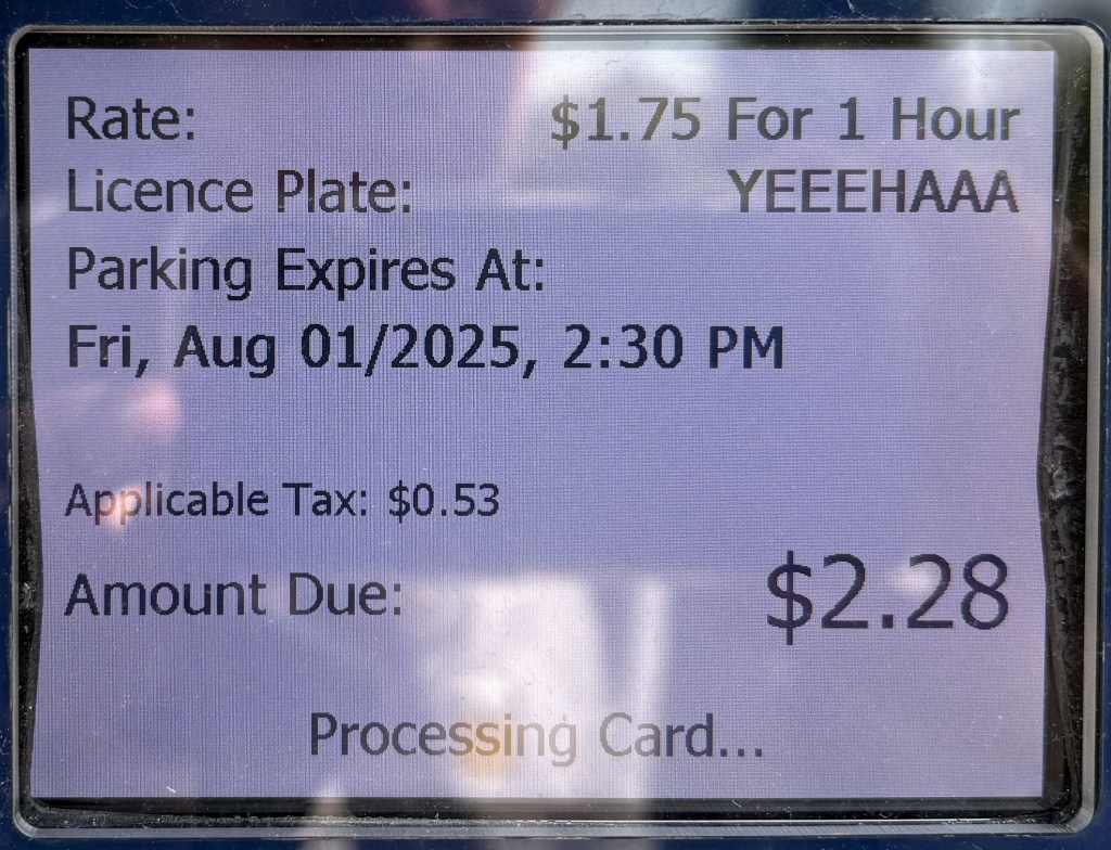
I already explained my disagreement with the Surrey Visitor Centre. Here is proof of the exorbitant parking fee I had to pay just to go in the building and find that they weren’t even there any more. I became even more upset this morning when I saw this photo as I was reviewing photos to post and saw that the city even added TAX to the parking fee!!

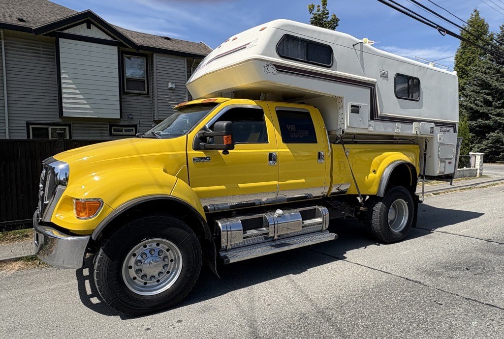
Fortunately I was easily distracted by something I had seen on my way there. My mind is always distracted by new “shiny objects,” and this one was indeed shiny.

THAT is a spiffy new Ford F-650 Crew Cab pickup truck, outfitted with a removeable camper called Bigfoot. I saw it parked in front of a house as I was driving on a city street, and after I passed it I turned around to go back and get a photo. I was alarmed when I saw it pulling out of where it had been parked and was prepared to pursue it (within reason). Fortunately the driver was only moving it across the street so he could get another vehicle out of his driveway.

My comparatively tiny Toyota Camry parked in front of it:

I spent a few minutes speaking with the owner, who proudly proclaimed the truck is one of only two in the area (camper sold separately). There was a sign in the back window indicating the owner is evidently in the septic system cleaning business, and clearly business is very good! Ironically (and I mean that in the very literal sense of the word) he was wearing a UNC Tarheels t-shirt! I pointed to it and asked if he had gone to school there (he was probably in his late 20’s). He replied no, he had bought it at local thrift shop for just a few bucks.

Those of you who know me are keenly aware of my obsession with buying unusual new t-shirts for only a few bucks at one of my favorite chain stores in the Mid-Atlantic states, so between the cool truck and the t-shirt story it helped make my day and get my mind off the goofy parking fee.

Another thing that impressed me during my brief stay near Vancouver were it’s many bridges. I will show you three of the ones I used personally. Most of these photos I found on the internet. Believe me I tried to find places where I could take my own photos but that quickly became a huge waste of time.

The first one I crossed was the Pattullo Bridge. As I crossed the old bridge I could see the ongoing construction of a much larger new bridge right next to it. For this one I have to resort to internet photos:

The old bridge, on the left, still in use:

(Photo credit: readsitenews.com)

You can see them beginning to build the concrete superstructure supports in the center of the photo above. They are much further along now than when that photo was taken.

The new bridge. The photo below is pretty much how it looked the day I drove over the old bridge:

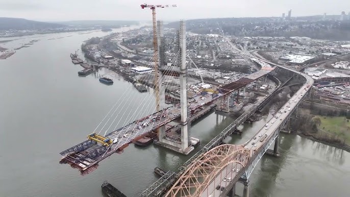
(Photo credit: TI Corp)

And to prove my point about it being a waste of time trying to take my own photos, I went out of my way to go to a place called Bridgeview Park. This was all I got for that effort:

I tried.

Another bridge I crossed several times while I was in the area is the Port Mann bridge. Perseverance paid off as I was finally able to find a nearby city street where I could get a good photo of it:

And finally, the Golden Ears Bridge, which I probably crossed at least a dozen time while I was staying in Maple Ridge.

(Photo credit: hgcacoustics.com)

I’ve tried to enlarge that photo but don’t seem to be able to. I don’t know why it was so difficult to find a photo of this beautiful bridge. I want to get this post finished but will try to find a better photo later and replace the one above.

So how’s it goin’, eh?

Two weeks in Canada and I have already seen so many amazing places. And I still have 6 weeks to go! I am going to wait a few more days to decide for sure but I believe I will be shortening some planned stops in Saskatchewan, and taking others off the to-do list completely, due to air quality from wildfire smoke in that province. I check the numbers every day, and they do fluctuate, but if they are anything other than low risk to my health I will probably pass.

The good news is that it will give me more time to revisit southwest British Columbia to do more things and revisit some of the places I’ve already been to. I didn’t budget enough time initially so now I’ll get another bite at the apple.

As I write this I am in Golden, BC, sitting at 3,303.33 feet elevation in the kitchen/dining area of the travel camper I am staying in for 6 nights.

I am near the base of a mountain north of Golden but it only takes me a few minutes to get down to the highway. The property is at the end of a dead-end road so it is remote and extremely quiet. The only thing I would change about it would be to put a huge net over it to keep the mosquitoes out! Not much my Airbnb host can do about that…

My first impressions of western Canada are all positive, mosquitoes notwithstanding. This is my first encounter with the pesky little insects this trip, but while I am out and about they really haven’t been a problem until this particular location.

People drive pretty fast in Canada, except people in RV’s who insist on driving the exact speed limit (or slower on inclines) and invariably have long queues behind them until they get to a passing zone. Can’t fault them for obeying the speed limit, though. Cities and towns have speed limits of 30, 40 or 50 km/h and the highways are generally 60 (in places with lots of curves), 80, 90 or 100 km/h, and the wide open road is often 110km/h. In National Parks the speed limit is never higher than 90 km/h, and in areas where people stop for viewpoints or to cross the road, much slower.

30km/h equates to 18.6 mph, 40 = 24.8, 50 = 31.1, 60 = 37.3, 70 = 43.5, 80 = 49.7, 90 = 55.9, 100 = 62.1, and top speed of 110 = 68.4 mph

So slower overall than we are used to in the US. I generally set my cruise control to around 5 or 6 km/h over the current limit and that keeps me pretty much in the regular flow of traffic. I finally switched my speedometer to metric because the conversions were driving me crazy. I had a cheat-sheet in my other car when I went to eastern Canada in 2019.

The roads have been in excellent condition, save for one I drove on my first day in-country which made me almost seasick. Fortunately that was the exception, not the rule. They may get a little worse the further north I go but I’ll just have to wait and see.

Drivers are very polite and there doesn’t seem to be any road rage up here.

The weather has been fantastic. The days often require only a t-shirt and shorts but the mornings and evenings cool down quite a bit so I may start and end the day with long pants and a sweatshirt, or at least a long-sleeved t-shirt. Now that I’m in the Canadian Rockies I wear long pants all the time but have layers for my upper body. Yesterday I was up at 6,300 feet elevation but mid-day it was very pleasant.

Thus far I have only traveled through the southern part of British Columbia, and now in Golden. I will be spending a few days in Alberta province starting in three days when I go down to Banff for 4 nights, and Calgary for one or two. I will then head further east to western Saskatchewan province, though as I mentioned above, some of those stops will likely be shortened or eliminated.

British Columbia badly needs rain but the Canadian Rockies have had a good bit so far this summer. East of the Rockies has also been dry, which is why they are having so many wildfires.

The scenery has been stunning. I am going to run out of superlatives to describe it. While planning this trip I noticed that the Canadian Rockies “weren’t that tall”. The highest points in the British Columbia and Alberta provinces are “only” 12,972 and 12,294 feet respectively. Colorado alone has 58 mountains taller than 14,000 feet. Well, now that I am here and looking at them with my own two eyes, I can say that the mountains in the Canadian Rockies, and elsewhere in western Canada that I have been to so far, are VERY IMPRESSIVE and many of them are unlike mountains I have seen elsewhere. I’ve taken lots of photos in the 6 National Parks I have been to, all within 4 hours of where I am now staying. I am staying “home” today to do laundry, wash my car, and download and review the photos I have taken the last few days and prep them for making additional posts.

Here is a tease of a Park I drove through yesterday:

Lots more where that came from, I assure you.

I haven’t seen nearly as many critters in these first two weeks as I expected to. I am always vigilant, especially when I am driving, and try to always have my digital camera within easy reach. I’ve only seen one black bear, a cub which ran across the road well ahead of me while I was in northeast Vancouver Island. I neglected to mention that in the post for that day. I saw a white-tail deer here in Golden, as I was driving down to the highway yesterday morning. It ran alongside the road to my left for a short distance and then stopped. I saw a moose cow (adult female) grazing just off the small road I was taking to get to a popular resort near Jasper, BC two days ago. I saw a herd of elk (thank you to my brother Steve for correcting me when I called them moose). I hadn’t looked at the photos on my computer yet and as you will see when I post the photos from Jasper they were all laying down and resting in a burnt-out wooded area just off a major highway, and just outside of town, so it wasn’t obvious exactly what they were. I have photos of a few birds of prey I have seen in various places. I am going to a Wolf Center just outside of Golden later this afternoon but that won’t count since they are in captivity.

I see warning signs for lots of things – deer, elk, bear (black and grizzly), moose, bison, mountain goats, and bighorn sheep (I still think they’re extinct – I have never had a confirmed sighting in all my travels in the US and now Canada). And yesterday I saw signs warning of frogs and salamanders on the road in a National Park west of here! I hope they’re not big enough to damage my car!!

No lions or tigers but they may be in Saskatchewan. I’ve heard they’re a pretty tough bunch over there…

I’ve driven just under 2,800 miles from when I crossed into Canada back on July 27 to last night when I filled my tank here in Golden. Gas prices are relatively high in Washington State and here in British Columbia. I expect them to drop in Alberta (once I get past Banff) and Saskatchewan provinces.

One thing I really like about traveling up here is that there are warning signs when you are about to go a considerable distance with no gas stations along the way. And there is no cell phone service across vast areas. Some days I go almost the whole day with no cell service. Verizon does make satellite texting for emergencies available when there is no cell service. If I start the day using Google Maps guidance on my smartphone for a specific destination it will work for quite a while but eventually stops if I’ve had no cell service for an extended period. This is why, for years, I’ve had a stand-alone GPS unit in my car. Even my new-to-me car doesn’t have a navigation system or GPS built in. Google Maps doesn’t always work.

I haven’t experienced any really bad crowds yet, but then I didn’t go into Vancouver or to a popular Garden destination in Victoria which probably would have been packed with people. The National Parks are so big it is fairly easy to get around within them, though at some of the popular stopping points the parking lots fill up pretty quickly, same as they do in the US. I do expect the city of Banff to be crowded, and I don’t know yet how many of the areas within the Park itself I can drive to. Jasper and Banff National Parks are both enormous, though some portions of Jasper are still closed due to the devastating wildfire they had last summer. I will give more specifics when I start posting photos from with each Park.

I was delighted to hear upon my arrival at the first National Park, where I planned to buy my senior annual pass, like I had in eastern Canada, that admission to all Canadian National Parks is free until September 2. Yay!

I feel like I’m forgetting something but when I think of it I’ll add it to another post.

Port Alice

This port is located down another road near Port Hardy. It is a very narrow, winding road and there were lots of logging roads which went off to the sides with big trucks driving very fast and kicking up lots of dust.

I drove for quite a while and finally arrived at a beautiful spot with lots of pickup trucks and other vehicles which had hauled boats on trailers to the water. I went in the office to ask some questions of the harbourmaster and as I was leaving I said “Thank you, I’m going to go take some photos of your lake”. She immediately responded “It’s the ocean”. Silly JohnBoy, that’s why it’s called a Port.

This body of water is the Neroutsos Inlet, named after Captain Cyril Demetrius Neroutsos.

Port Alice is in the lower right quadrant of the map above.

After taking my photos, and forgoing a side trip which the young ladies at the Visitor Center in Port McNeill told me about (on a long gravel and dirt road, too far off the paved road to attempt with all the logging trucks running around, to find the “Devil’s Bath”) I reversed course and headed back to Campbell River.

I came across this sign, which I had seen in another location not conducive to stopping to take a photo of it.

It reminded me of the many humorous road signs I saw when I traveled to Canada’s Maritime Provinces in 2019 (see multiple posts). I haven’t seen too many so far this trip but maybe I will when I start getting out into the countryside.


Shortly after I got home I went back out to take a photo of a helicopter I saw at the hospital the day I arrived in town, and saw this ominous cloud in the sky as I drove towards the highway. I knew it looked very different from other clouds in the sky that day.

Turns out it was the initial smoke plume from what became the Wesley Ridge Fire, further southeast down the island near Nanaimo. It was discovered around midnight the night before I took this photo and has grown steadily since then. It is near a small lake and many people have been evacuated from their homes. There was no visible smoke when I left early the next morning to drive to Nanaimo to take a ferry over to Vancouver but I could see the smoke at ground level once I got down there and could definitely smell it. Fortunately, no one has been injured fighting it.

Victoria to Duncan, BC

After two nights in Victoria it was time to head northwest, up the eastern (inland) side of Vancouver Island. Shortly after leaving the city I immediately I started to see huge highway signs warning of Elk. Not deer. ELK.

Oh, they have deer too, mind you…

… but Elk are much larger and pose a greater risk to motorists. Oh, and they bears up here too. Black bears AND grizzly bears. I brought two cans of bear spray for this trip. A small black bear ran across the road well ahead of me the other day at about 10 in the morning. One must always be vigilant when driving.

Soon after leaving town I stopped as a rest area near Malahat. I didn’t need to rest, but wanted to take in the scenic view.

And for those of you with eagle eyes, yes, that is snow on the distant mountains in the upper right corner of the photo.

When I texted that photo to friends and family members I said that it was the mountains in the Olympic National Park in northwest Washington State. That is not correct. It is actually Mount Baker, and other mountains, still in northwest Washington but further inland, up near the Canadian land border, looking east from this vantage point, not south.

Another lake I could see from another scenic overlook just a little ways up the road:

I got back on the highway and soon arrived in the little town of Duncan. Duncan is known for it’s totem poles. There were lots of them scattered around town but the visitor center there wasn’t open yet and I needed a map to find them all. It was also early in the morning and the sun angle was not conducive to taking great photos.

Here are a few that I was able to find:

And I spotted this big guy across an intersection, in front a round office building.

It is called Cedar Man, and is the widest totem pole in the world, measuring 5 feet, eleven inches across. The carver is a man whose “English name” is Richard Hunt. He is a member of the Kwagu’l indigenous tribe and his given name is actually Gwe-la-y-gwe-la-gya-les. I got that information from the small sign at the base of the pole, which is present at each pole in town.

Indigenous words are all presented in a very elaborate font which I can’t replicate here, but when I start posting more photos of totem poles and their carvers after I have researched them in more detail I will show you photographic evidence of what I’m talking about.

A little further north of Duncan I turned off to head over to Mount Prevost, which promised fantastic views of the area.

I left the house in the photo to give viewers some reference of just how tall the mountain is (2,585 feet). I drove up the road towards the parking area but the road was closed before I got to it and I could tell it was still quite a climb to the top. I am not a hiker so I turned around and left. There is quite a view, though, based on photos I found online.

As I was driving back to the main highway I saw this sign which shows the current fire level risk in Vancouver Island.


I read this morning that the fires in Manitoba province are getting worse and even more have been detected in just the last week. They have already experienced three times the average amount of land loss to wildfires, and tens of thousands of people have been evacuated, mostly by air (not many roads up north). Think about that. Tens of thousands. There are still large, out of control fires in northern Saskatchewan province, too. All of them are producing dangerous smoke and there are health warnings in many areas well south of the actual fires.

This area has been under a huge high pressure dome the entire week I’ve been here. That’s good for me, nice clear days and pleasant temperatures, but bad for residents of those two provinces because high pressure keeps the smoke close to the ground. The weather forecast indicates that that situation is fixin’ to change here in a few days and hopefully that will help clear some of the smoke out.

I am going to resume booking my Airbnb’s along my original route and will make a bee line for Saskatchewan province and get that portion of the trip done so I can focus on Alberta and British Columbia. There are always new fires popping up and the situation can still change on short notice. Canada has excellent resources for monitoring all of the various fires so I will be well informed as to their status.

Downtown Victoria, BC

Monday I drove into downtown Victoria and parked in a multi-story Parkade deck about three blocks from the Inner Harbour. My plan was to walk to see many of the various attractions I had noted on my “things to do” list. I was a little concerned that the city and the attractions might be too crowded because large cruise ships dock near Victoria and discharge many of their passengers into town. It wasn’t nearly as bad as I feared it might be. Here are some of the things I saw as I walked around the city:

An “on the sidewalk” toilet:

A store selling some pretty amusing t-shirts:

Later in the day I saw two different people wearing the raven t-shirt. I believe what I saw out by the water was a crow, not a raven. Ravens have noticeably curved beaks while crows do not.

Some words of wisdom from the late Jimmy Dean (who died in 2010, yet still promotes his products in radio and tv ads):

A very hungry seagull which, surprisingly, I didn’t see all that many of as I walked around by the harbour.

City Hall:

Signs near Chinatown, including special street name signs:

I had to wait in order to walk out into the middle of the street for that one.

Some amusing signs:

Some nice tilework in an entryway to a courtyard in the open space between buildings:

But the thing that impressed me the most were all the baskets of pretty flowers hanging on the lamp posts around town:

They were everywhere. I think that always adds a nice look to a city street. I also walked around many residential streets near the harbour and they, too, were well adorned with pretty flower beds. The only place that overdid it a bit, IMHO, was the Empress Hotel, a swanky hotel near the harbour. Their display was quite gaudy and could have been cut way back without sacrificing anything.

I could have gone in to the Empress for high tea and sipped the nectar with my pinky extended but I’m too cheap.

I saw this statue near the harbour as well:

“I will now make this bird disappear by passing it through this horseshoe”

About a block from the Empress Hotel was this large whale topiary:

And finally, outside the ferry terminal building, an example why you might not want to buy a dark blue car instead of a lime green one:

My first afternoon on Vancouver Island

The ferry from Port Angeles, Washington State dropped us off in the harbour in Victoria mid-afternoon. I had a scenic drive which would take two hours each way planned so I decided to go ahead and get it checked off the list since I didn’t know my way around the city. It was easy to get on Route 1 (the Trans-Canada Highway) from the ferry terminal and then I hopped on Route 14 which would take me around the bottom of the island to the southwest and then follow the Strait of Juan de Fuca which separates Vancouver Island from Washington State.

I passed through little towns like Langford, Sooke, Shirley and Jordan River. The road eventually turned inland and climbed up into the San Juan Ridge of mountains. Ultimately the road would end at Port Renfrew. I never made it that far. Once the road started climbing up into the woods, a) the drive became like something I could do in North Carolina or Virginia – driving through a tunnel of trees, but more importantly, b) the road had lots of curves, but more distressing were the severe undulations which often caused the car to almost bottom out if I went too fast. I now drive a Toyota Camry which, when loaded with all my stuff, sits pretty low to the ground (and I bought it with low profile tires on it compared to what I normally buy). I finally said “enough” and turned around. I was getting carsick on land!

Here are some panoramas looking west towards Washington State. The photos make them look tiny, especially using the panorama format, but actually looking at the mountains of Olympic National Park was very impressive, even from a distance.

This crow landed on the rock in front of me as I was getting ready to back out from my parking place by the beach.

That photo was taken at Jordan River and from there it would take me about an hour to get to my Airbnb for the next two nights.

Welcome to Canada, JohnBoy !!

I crossed from Port Angeles, Washington to Victoria, BC, Canada on Sunday, July 27.

We sailed aboard the MV Coho ferry:

It took about an hour and a half to traverse the Salish Sea in the Strait of Juan de Fuca before arriving in Victoria, British Columbia. Victoria is located at the southeastern end of Vancouver Island, a huge island about the size of Kansas. Vancouver Island is the 8th largest island in the world.

Some of the deckhands prepping our ship for docking:

Some of the things we saw as we approached the harbour (I’m in Canada now and have to talk the talk):

A dichotomy of speed:

The Air Traffic Control tower (well, building) for managing approaching and departing seaplanes. One of the photos above shows a buoy with a sign reading “Water Airport”

Part of the Canadian Coast Guard fleet:

And once I got on land I treated myself to a reward, confirming that I was actually in Canada!


I have been on the road 2 days shy of 4 weeks. When I arrived at the ferry terminal in Port Angeles, immediately before leaving the United States, I had driven exactly 4,600 miles since leaving Durham, 759 miles over my projection (which was point-to-point mileage between the towns I would be staying in and didn’t include side trips).

JohnBoy travel update

I am writing this post from Boise, Idaho, where yesterday I went to the World Center for Birds of Prey facility operated by the Peregrine Foundation (think California Condors, Red-tail Hawks, etc.). I was there almost 2 1/2 hours and took lots of pictures which I promise I will post very soon. I travel up to Seattle tomorrow and will be there 4 nights before crossing into Canada, so I hope to use the early mornings and evenings there to make more posts. I also have several “multiple-nights in one place” stays the first two weeks in Canada so that should enable me to get caught up since I won’t have to unload and reload my car every day or two!

I’ve also been VERY lucky with weather in my first three weeks on the road but am sure I will encounter rainy days sooner or later. Many areas out here need the rain, but most of it I have encountered so far has been while I was driving or at night.

I have good news and bad news concerning wildfires. The bad news for people in northwest Oregon and southwest Washington state is that there are two wildfires there which just recently started and are destroying homes and businesses. The Cram fire in Oregon is currently the largest active wildfire in the United States and developed very quickly. The Burdoin fire, on the Washington side of the Columbia River Gorge, is also wreaking havoc. Crews are working diligently to contain both fires.

Fortunately for me they are both well west of the route I will be taking tomorrow morning from Boise to where I will be staying in Bellevue, Washington. I’m sure I will see the smoke, and possibly even have to drive through some, but I don’t expect any detours such as what I opted to take around Kansas City late last week to avoid massive flooding there.

The good news in Canada and Alaska is that, for now, the wildfires I have been monitoring there appear to be under control and should not be a direct threat to my plans. Of course, more could start at any time. There were Red Flag warnings in western Wyoming two days ago for conditions which could have enhanced wildfire development but I didn’t see any sign of any fires anywhere.

So fingers crossed that conditions will continue to be favorable for me.


And one update on travel conditions in western North Carolina, along the Blue Ridge Parkway. Yesterday it was announced that a 12-mile section has been reopened after major repairs of damage caused by Hurricane Helene last fall. Here is a “before” photo I found online this morning which demonstrates why the repairs (rebuilding, actually) is taking so long.

(Photo credit: FOX Weather)

There are still many more areas along the Parkway in North Carolina which need rebuilding, and logistically it is more difficult to get materials up there to make the repairs than it was for what they had to do on interstate 40. The Parkway is a major tourist draw to western NC so I am sure they are progressing as quickly, but safely, as they can.

So here’s the plan for 2025

No photo. (Already he starts with the “no photo” nonsense….)

I still plan to leave Durham July 1 – a week from tomorrow. Most of the first two weeks will be visiting friends and family in Pennsylvania and Ohio. I doubt if I will post anything during that time (well, I might sneak one or two in since I generally wake up well before anyone else when I visit people).

Once I hit the road in earnest I will be making a series of one or two night stops as I work my way to Seattle WA. I will stay there 4 nights before crossing into Canada. All those stops have already been booked, and I have a few activities and photo ops planned.

After I cross into Canada I plan to spend 8 weeks visiting the southern parts of British Columbia and Alberta provinces, and the southwestern part of Saskatchewan.

Now comes the tricky part. Wildfires. The worst wildfire in Canada this year (so far) seems to be in the upper part of Manitoba, well east of my target area. BUT. Many fires have erupted in all three provinces I plan to spend my time in and are getting more than a little close for comfort. I have booked about three of my projected 8 weeks in Canada already. That puts me near Banff National Park in the Canadian Rockies. After that, who knows…. I am not booking anything else until I get my boots on the ground in Canada and can assess the situation at that time. I have Plans B, C, D and E mapped out, just in case.

My original plan was to spend 8 weeks in Canada, return to Seattle, put my car in storage and fly to Alaska! I have 5 weeks available to spend up there before I must start my departure from Seattle to make my rambling trip through the western and southern US on my way back to Durham by Thanksgiving.

For anyone who might be thinking of robbing my apartment, I have cleaned out all the food from my refrigerator and freezer and have taken my clothes to Asheville and Swannanoa in WNC to help the victims of Hurricane Helene, so don’t waste your time picking the carcass apart in Durham…. not much left here! I have all the good stuff with me – my wits, phone, computer, cameras, FitBit, prescription meds, Passport, new-to-me car and, of course, my Platinum card.

I will start posting some pictures once I depart to head west (instead of north) about three weeks from now, both with road trip pics, though there will be many travel days when I just drive on the dreaded interstate, and several stops I have planned around specific activities. Once I get to Canada I will stop the hysterical historical photos and stories and focus on real time photos of The Great White North (let’s hope it’s not white quite yet).