Before I post any more Park pictures let me show part of the Jasper National Park Visitor Guide, published and distributed to Park guests by Parks Canada.
(Photo credit: Parks Canada)
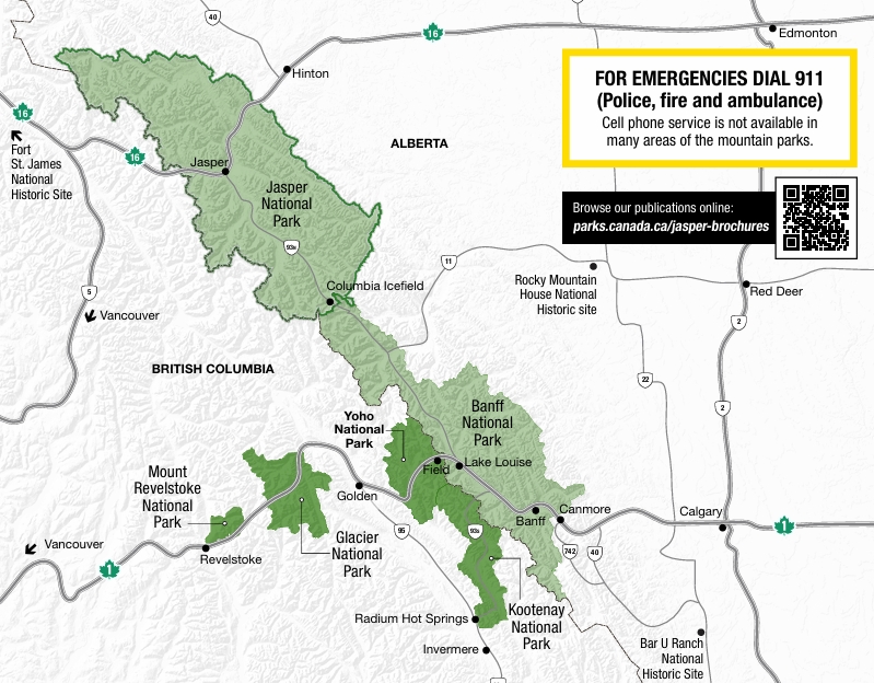
This will give you the “lay of the land” as I describe the Parks I went through while I was based in the town of Golden (bottom center of map, above the words Glacier National Park). The two biggest Parks are Jasper and Banff, both in light green on the map above. They hug the peaks of the Canadian Rockies.
Jasper is the largest, at 4,335 square miles. This makes it larger than Yellowstone, one of the best known American National Parks in northwest Wyoming, which covers 3,472 square miles. It is hard to visualize the comparison because Yellowstone is basically rectangular whereas Jasper is elongated as it spreads down the Canadian Rockies. Believe me, it covers a lot of territory.
Banff, perhaps the best known Canadian National Park, covers 2,564 square miles. That makes it a little less than half the size of Jasper. It stretches out to about the same length in the Rockies but isn’t as wide in the northwest portion.
Kootenay, which I already made one post about, is the next largest. The map above is a little deceiving with regard to Kootenay and Yoho, which are shown in the same color. It appears that a highway separates them, but there is more of Yoho on the south side of the Trans Canada Highway than the map above indicates. The map in the Yoho Visitor Guide gives a much more accurate depiction:

(Photo credit: Parks Canada)
This second map clearly shows how I drove through Kootenay from Radium Hot Springs at the bottom of the map, out to the Trans Canada Highway (Route 1) in Banff NP, left towards Lake Louise, then curving left again to enter Yoho NP and drive past the town of Field to get to Golden.
The two remaining Parks, Glacier and Mount Revelstoke, are both quite small and I drove west to see both of them the third day I was based in Golden.
