This is Scott’s current project:

You are looking at Pisces VI, a 70’s era research “submersible” that Scott purchased in December of 2015. The reason I said “specially built workshop” in the previous post is that Pisces VI weighed 16,000 pounds and the floor needed extra reinforcement to handle the weight. The workshop ceiling is 38 feet high and there are special cranes to lift and move the craft.
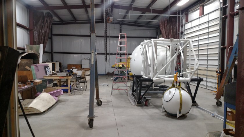
Scott has assembled a staff and crew of over a dozen people from all walks of life – engineers, scientists, machinists and even an electrical engineer who used to work for NASA, to help him rebuild Pisces VI to become the deepest diving privately owned submersible in the world. He found it in storage in upstate Wisconsin and spent months negotiating the price down from over a half million dollars (it cost many times that to build originally) to “only” $30,000. He put it on a large trailer and hauled it to Kansas.
Scott’s family owns a chain of highly successful hardware stores in Kansas. He is fifth generation, and at one point was CEO of the multi-million dollar company, but has given that up to pursue his passion of rebuilding Pisces VI to become the deepest diving privately owned submersible in the world. He plans to use it for research projects (largely universities and private foundations) and TV and film projects all over the world. There are two shipping crates outside the shop, one to transport Pisces VI itself and the other to serve as a mobile “office” to accommodate the crew and support staff, as well as computers and other special equipment, wherever they are needed.

Scott and his crew have been engaged in this project for almost two years and are about halfway through the rebuild. Pisces has been gutted and they are currently working on custom-building newer, lightweight components for the interior. When completed it will have state of the art electronics and robotic arms and cameras. It will hold a pilot and 3 passengers. It can operate at a depth of 6,600 feet for up to 12 hours (with a reserve of 10 times that for safety). A modern US military submarine can achieve a depth of only 1,600 feet.
For more information on this project, and to meet some of the people involved, go to his website at http://www.piscessub.com
There are several newspaper and TV stories about Scott and his endeavors which you can find online by Googling his name and “submarine”.