September 13, 2025
I’ve referenced THE Alaska Highway quite a bit the past few days, but this is a discussion about the highways within the state. They are technically intrastate and not interstate highways because they do not connect to another US state.
I made a post in real-time shortly after arriving in Anchorage about the highway system. I will repeat part of it again and add a photo of my AAA map on which I’ve highlighted all I roads I actually drove on.

(Photo credit: AAA.com Alaska Map)
There are 4 major highways in Alaska, not surprisingly numbered 1, 2, 3 and 4. Yes, there are other, smaller ones I’ll talk about in a minute.
1 – Runs from Tok, southwest through Glennallen, west through Anchorage and south to Homer. 538 miles, 9 hrs 38 min (per Google).
2 – Runs from the Canadian border with Yukon, northwest through Tok, Delta Junction, and Fairbanks plus a few more miles to Livengood. 624 miles, 7 hrs 34 min. The part that runs from the border to Delta Junction is the westernmost part of THE Alaska Highway.
3 – Runs from Palmer north to Fairbanks. 327 miles, 5 hrs 36 min.
4 – Runs from Delta Junction, south through Glennallen to Valdez. 268 miles, 4 hrs 37 min.
I have driven on almost all parts of the those four, and several of the others (to Homer, Seward and Valdez). The picture I posted above does not include the two short roads I drove on in the Alaska panhandle – going south to Haines and then north from Skagway. I took a ferry between the two towns which saved quite a bit of driving by not having to go back up to the Alaska Highway to get to Skagway.
Yes, there are some shorter stretches of highway with different numbers:
11 – The “Dalton Highway” north from Livengood to Prudhoe Bay, a dangerous stretch of road not for the faint of heart and not considered a major highway. I did NOT drive on it.
9 – Which branches off from 1 to run south to Seward.
5 – Which branches off from 2 to run northeast to Chicken. I did NOT drive on it as I was told by one of my Airbnb hosts in Tok that it is either unpaved or not in good shape.
8 – I had not listed this one previously. It runs west to east in the center of the map above between Cantwell and Paxson. The reason I didn’t include it (or drive on it) is that it is a seasonal road and is closed in the winter. It may or may not have even been open while I was there in mid to late September, but I had read numerous places that if you rent a vehicle in Alaska the rental company will likely forbid you to drive on it. I heard stories that it is very rough, and that flat tires are common.
After studying various maps more closely I have discovered a few other very short roads, but my trip focused solely on the 4 primary highways plus ones that would get me to the coastal towns I wanted to visit.
I also mentioned in my original highway post that these primary roads are located in the southeast part of what I call the “mainland” – excluding the Aleutian Islands and the panhandle. Here is another photo of the AAA map illustrating that point.
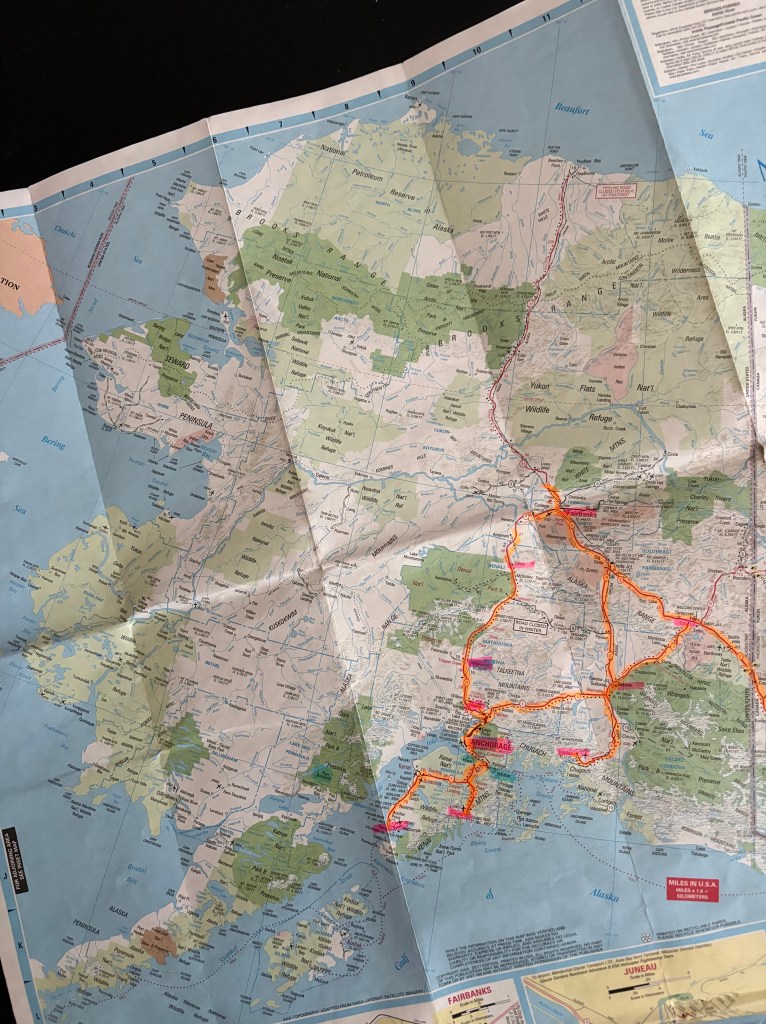
(Photo credit AAA.com Alaska Map)
