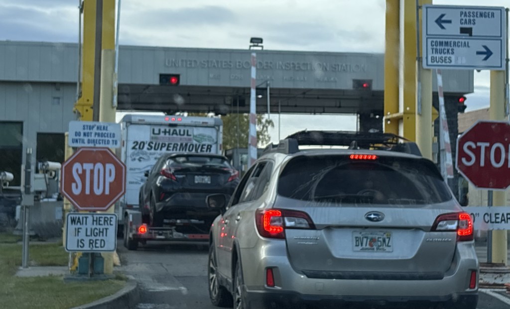
Real time post – A week ago today I crossed the border from the Yukon Territory into the United States near Beaver Creek, YT. It was around 6pm PDT, which then became 5pm AKDT when I crossed the line. As big as Alaska is, most of it is in one time zone – except the extreme southern Aleutian Islands which are on Hawaii Time. And Alaska only has one Area Code – 907.
Actually, I was already in the US – I had crossed the line about 30 miles earlier but the Customs Inspection Station wasn’t until later. I guess they really want to nab you before you can slink back into Canada.
When it got to be my turn it was pretty straightforward until we got to the subject of fruit. The agent was only interested in my 1 1/3 bags of mandarin oranges which I had purchased at a Walmart in Prince George, BC. He didn’t seem to care about the one banana I had left, or the two partial bags of apples I was packing.
He confiscated them. (He took two large potted plants from the woman in the car ahead of me. Lord knows what was in the U-Haul her traveling companion was driving).
Maybe he was hungry and was outfitting his apartment.
Anyway – I was cleared to go shortly thereafter and on my way to Tok (pronounced toke), AK.
And I just talked about road conditions in my last post. The first 10 miles or so of the highway in the US were pristine. Newly paved and without blemishes. (Take THAT, Canada… we know how to do roads over here!)
Then things started to go south. Same issues as in Canada except little or no warning at offending spots, and POTHOLES! Lots of POTHOLES! I honestly don’t think I saw a single pothole on the Alaska Highway in the Yukon. I swear they must go out every morning and patch them before they get worse. Not so on the US side.
Guess AKDOT needs to tuck it’s tail between it’s legs….
In their defense, I will give AKDOT kudos for repairing the road near Anchorage after a major earthquake many years ago. I remember seeing news stories about how they removed and replaced entire sections of the badly damaged roadway in record time. They apparently had all the materials ready to go, and moved in as soon as it was safe to do the rebuild.
I should have posted this earlier after I had driven across the southern edge of British Columbia the second week I was in Canada. During that leg of my trip I had to drive across a few small mountains (fortunately I drive around most of the big ones) and in lots of places the speed limit would drop as I approached turns, not uncommon on mountain roads. Now I will admit I sometimes channel my inner Shane van Gisbergen (* see footnote at end of post) and take some of these turns at speed, going wide on entry, hitting the apex, and going wide on exit. I am an experienced driver (though not on the proverbial closed course, so don’t start emulating me – I will plead the fifth) and only do this when I am well aware of the lack of traffic around me. In fact, when I was on Vancouver Island and drove north to Port Hardy my Airbnb host told me – “You will enjoy the road going up there. It is in good shape and you may not even need to slow down, just hold onto the wheel with both hands”. He was right!
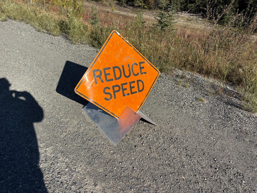
I have learned, however, that when you see this sign:
that you need to SLOW DOWN. In Canada, when they say slow down they mean it! This also rang true in the Canadian Rockies. In the Canadian National Parks their roads are wide, sometimes multi-lane affairs (with passing lanes in some areas) and with a 90/kph speed limit in most places, but on tight turns you still need to slow down.
Even further evidence of this is when I crossed the southern edge of the Yukon Territory on my way west to Alaska. I was traveling on the Alaska Highway, what would be known as the Trans Canada Highway in other parts of Canada, is still referred to by its former name once one gets close to the US state. Because of the extreme cold this far north, parts of the Alaska Highway deteriorate rather quickly as potholes develop and/or the roadway “heaves,” creating undulations which, if repeated over a short distance, cause your vehicle to “porpoise” as if you were a dolphin swimming in front of a cruise ship. At full speed the result of these, usually unexpected, undulations can become catastrophic, hence the need to SLOW DOWN. These conditions can develop very quickly and randomly so instead of permanent signs, as was shown above, the Canadian Department of Transportation (probably called Transportation Canada) puts out temporary signs at each bad spot in the road.
And there are many.
Sometimes you only get the second sign, indicating a bump or dip in the road (which you can also see in the photo above. This one didn’t require any patches but can still catch the driver off guard), but the two signs generally travel in pairs. And God forbid you see an orange flag next to the Slow Down sign, as it means a severe undulation or road heave, which is sometimes like driving over a speed bump (or as Peter Sellers called it in the Inspector Clouseau movies, a “bimp”). Remember it – Orange Flag means SLOW DOWN, and big yellow sign saying SLOW means SLOW DOWN.
Now in addition to the signs, during the day the driver can often see major patches made on the road in advance, as they are all black of an otherwise gray roadway, and with black tire marks from the heavy equipment used to make the repairs. And often, if the repairs were major, they result in a very uneven surface, again necessitating a reduction in speed. I wouldn’t want to drive these roads at night – not only because of the risk of animals in the road, but also the inability to see the defects before arriving at them.
When I got in the extreme western part of the Yukon, “Transportation Canada” evidently ran out of small signs as there were NUMEROUS, major patches which were not marked (except an occasional orange flag). So in addition to worrying about animals in the road I also had to be on my toes for road conditions. I would sometimes cross to the opposite lane if the damage was confined to my side, again, well aware of other traffic around me.
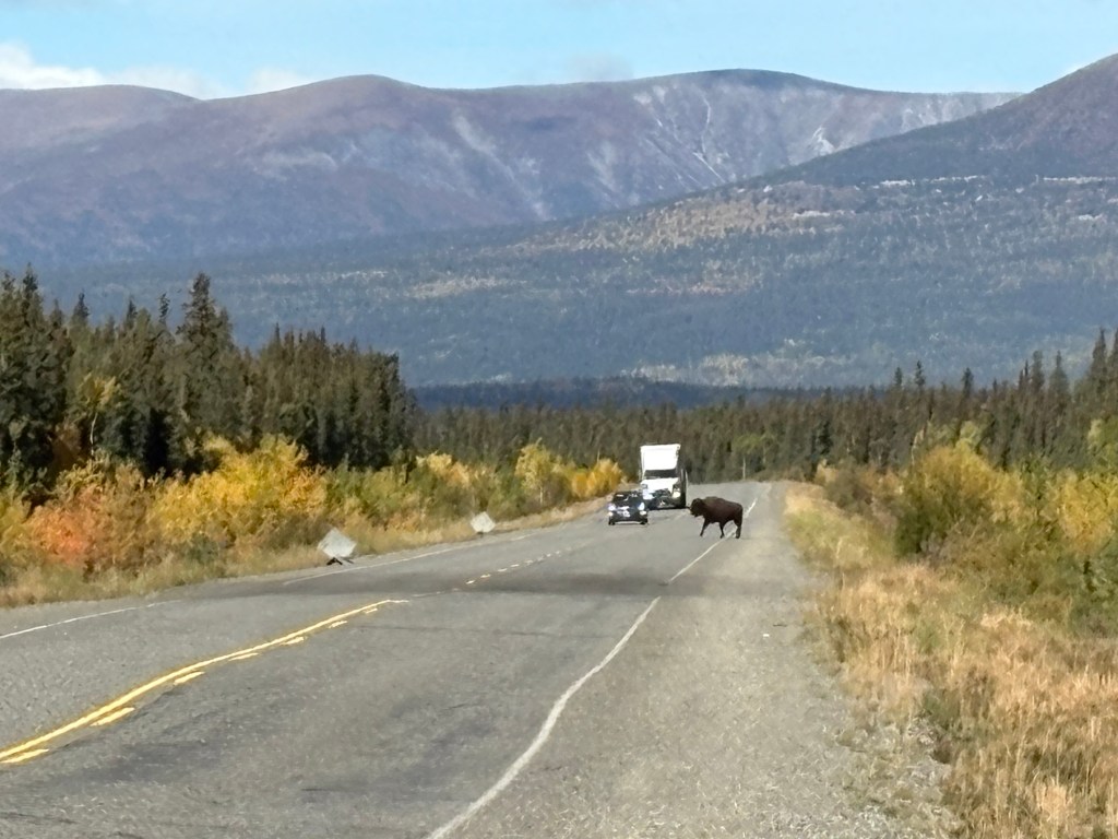
And speaking of animals in the road – as I was taking the two orange sign photos above I saw two bison casually cross the road well ahead of me:
If I hadn’t stopped to take my pictures I would have missed it. One of the FEW wildlife sightings I have had during this entire trip.
And I will also note that the car which had stopped to let the bison cross the road also stopped when she got up to my car to ask if I had broken down. I assured her, no, I was just out of the car taking pictures but thanked her for her concern and for stopping to inquire. Before she drove off, she observed “They’re not tame” and I said “No ma’am, they’re not.”
Shane van Gisbergen is race car driver from New Zealand. He used to race in the Australian “Supercar” series but came to America to compete in the inaugural NASCAR Cup Series street race in Chicago three years ago. He won. His first ever race in a Cup car, which some full time NASCAR drivers can’t even drive, AND he is used to steering from the right side of the car! Trackhouse Racing team owner Justin Marks, himself a very successful road course driver, had provided a car for him to use in the race and immediately signed him to a full-time contract. He now competes full time in the Cup Series and wins most of the road course and street races he participates in, including the Xfinity “minor league” Series. Experienced NASCAR drivers openly marvel at his ability. He still struggles on the ovals, but he’s a damn good driver and loves his NASCAR!
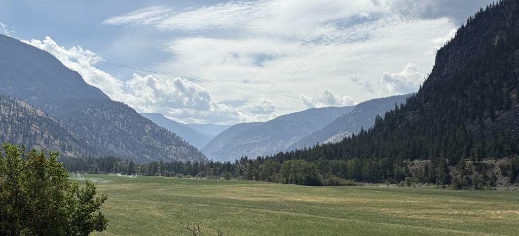
I got my first loooong driving day in Canada out of the way early in the trip. I had only been in Canada a little over a week and I needed to drive the majority of the way across southern British Columbia to the town of Cranbrook. Mapquest indicated point-to-point between my two Airbnb’s was about 500 miles and would take a little over 9 hours. I would drive east a short distance on the Trans Canada Highway (which hasn’t given me a reason yet to call it “the dreaded TCH”), before turning right on BC Highway 3, the “Crowsnest Highway” to continue east. I would be on it the rest of the way, and it continues all the way to Alberta province.
I recently posted a few photos in the “tease” post of the small wildfire I saw as soon as I exited the TCH near the town of Hope. I had stopped at a gas station (previously planned), and the fire was burning on a steep hillside behind the gas station and on the opposite side of the exit I had just taken. I stayed there a little while to watch a helicopter come and go, about every 4 minutes, to drop a large “bucket” of water on specific spots. I have no idea how much water was dropped on each trip but given the size of the helicopter I’m guessing it may only be about a third the size of my car.
The folks inside the gas station said the fire had been burning about a month and hadn’t gotten better or worse during that time. It was still classified as “out of control” the day I was there, and is STILL smoldering as I write this about another month later, but is now classified as “being held”. British Columbia as a whole is still bone dry and the fire danger is extreme. Parks Canada just implemented fire restrictions in Jasper and Banff National Parks, in the Canadian Rockies, which had been low risk but are now on the extreme list along with all of BC.
Here are some of the things I saw as I drove east towards Cranbrook:
There was a fairly substantial overcast to start the day but it would clear up and be a rather pleasant drive.
Route 3 kind of weaved between lots of large mountains but I only experienced a significant elevation change a handful of times. I also started seeing warning signs about various animals I would rather not hit with my car – bears, deer and elk, moose and even these guys:
Canada frequently covers several bases with a LARGE sign showing images of three or four animals, something I have not seen done in the US.
There was a small river which ran alongside the highway various places and at one point I saw this unusual watercraft on a pedestal just off the roadway:
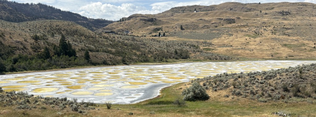
Further up the road there were several cars pulled over and people were milling about with their cameras. I stopped, grabbed my cameras, and joined them – thinking it was an animal sighting. I was mistaken. It was an unusual lake which has significance to the indigenous people of the area.
I’m guessing the largest circles are probably 10-12 feet across.
I have other photos of the signage explaining the significance of the lake but have not had time to read them or research the issue further. I was near the Okanagan (pronounced oak-uh-NOGGIN) Valley, known for large farms and fruit groves, among other things, and will be spending more time there later in the trip when I stop in Kamloops. I did drive past some farm stands after taking these photos.
There is a pronounced indigenous presence in various places throughout the western US but nothing like it is up here. Indigenous tribes are EVERYWHERE in western Canada, and make their presence known. They sometimes pool their resources with other local tribes to help protect the greater good and provide resources for their people. Many large commercial Canadian ventures (like WhistlerBlackcomb ski resort, northeast of Vancouver) sit on indigenous land.
At one point when the highway did climb to a fairly high elevation we had to stop for a one-lane section of the roadway due to construction. I was stopped behind this truck, a support vehicle for the Snowbirds, Canada’s precision flying team, which has been putting on airshows throughout the country during the summer.
I recently posted a photo in the “tease” post of one of their jets atop a pedestal outside the Moose Jaw, Saskatchewan, Visitor Information Center. The Snowbirds are based at a military base just south of Moose Jaw.
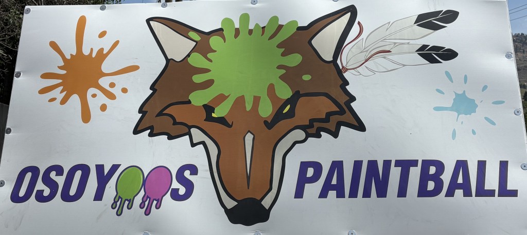
I soon came to the town of Osoyoos (pronounced oh-SUE-yuss, NOT oh-SOY-yoos as it appears). I became interested in Osoyoos because of a billboard I saw advertising a business there and decided I would stop in town for lunch.
Another climb to elevation and there was a scenic overlook (they call them Viewpoints up here) which showed a rather expansive town with two large lakes.
I would have guessed this was the west side of town, because of my direction of travel, but looking at the map I realize this is the north side – significant for a reason I will explain shortly.
While I was in town I stopped at the business I saw advertised as I approached town. It is a Paintball facility, and I really like their logo. I found the place but it didn’t seem to be open. The owner pulled up just as I was about to leave. Unfortunately he didn’t have any t-shirts in my size, so I left empty-handed. Here is their logo, on their sign next to the highway.
I climbed another big hill as I was leaving town and had a great view of the south lake.
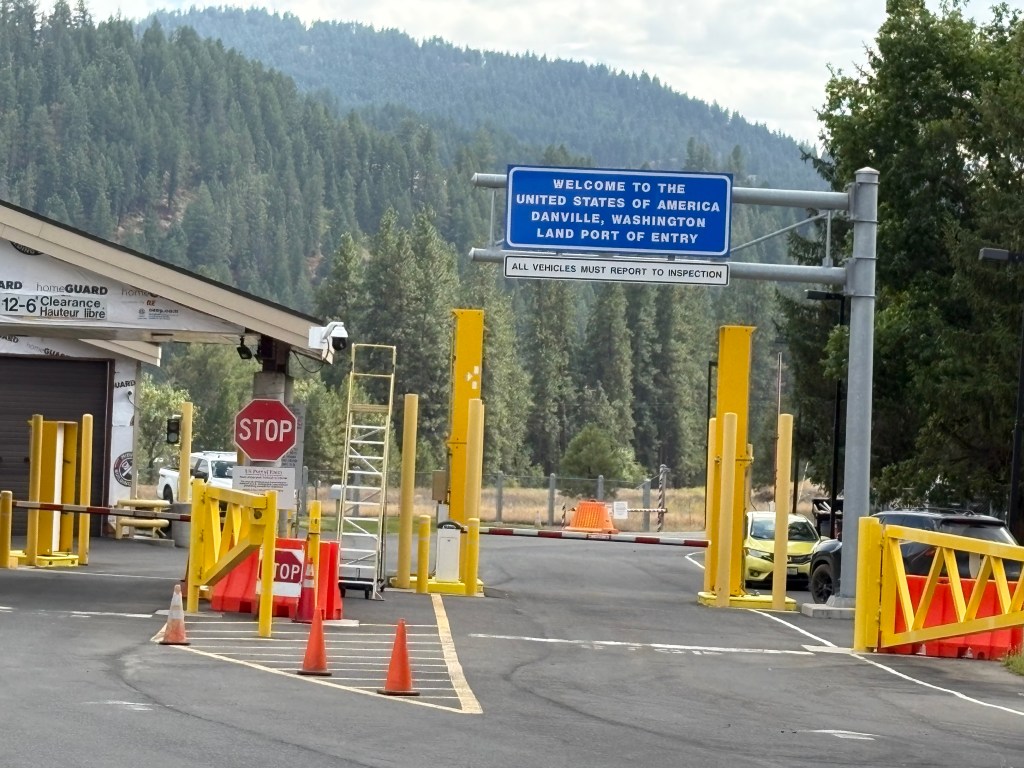
This is significant because the majority of the south lake is in the United States! The town of Osoyoos, between the two lakes, is only a very short distance from the border.
Further east on the Crowsnest Highway, at the town of Almond Gardens, I turned right at one of the many signs I had seen during my drive indicating “turn right to US Border.” I forget the exact distance but it was probably less than a mile:
I turned right around and headed back to Highway 3 and my journey east. Not feeling homesick yet – by any stretch of the imagination!
I stopped in the little town of Castlegar, which had been highly recommended by one of the folks in the Campbell River Visitor Center. I spoke with a young man at the Visitor Center there, picked up maps and brochures, but was already “on the clock” to make it to Cranbrook before dark so I told him I would probably return there someday. Someday is today. I am sitting in my Airbnb in Castlegar as I make this post, and the area has exceeded my expectations. I will save the photos I took yesterday when I arrived and today while I was out and about. They will have to wait their turn and be posted in sequence, but they will be worth waiting for.
The remainder of my drive to Cranbrook went without incident. I posted photos in the “tease” post of the amazing sight of a portion of the southern Canadian Rockies which I took just as the sun was setting. I was hoping for a repeat performance the next night, but low clouds spoiled it. It doesn’t look like I will get another bite at that apple this trip.
It ended up being just over 12 hours in the car because of all the stops I made, but it was a very enjoyable day.
This port is located down another road near Port Hardy. It is a very narrow, winding road and there were lots of logging roads which went off to the sides with big trucks driving very fast and kicking up lots of dust.
I drove for quite a while and finally arrived at a beautiful spot with lots of pickup trucks and other vehicles which had hauled boats on trailers to the water. I went in the office to ask some questions of the harbourmaster and as I was leaving I said “Thank you, I’m going to go take some photos of your lake”. She immediately responded “It’s the ocean”. Silly JohnBoy, that’s why it’s called a Port.
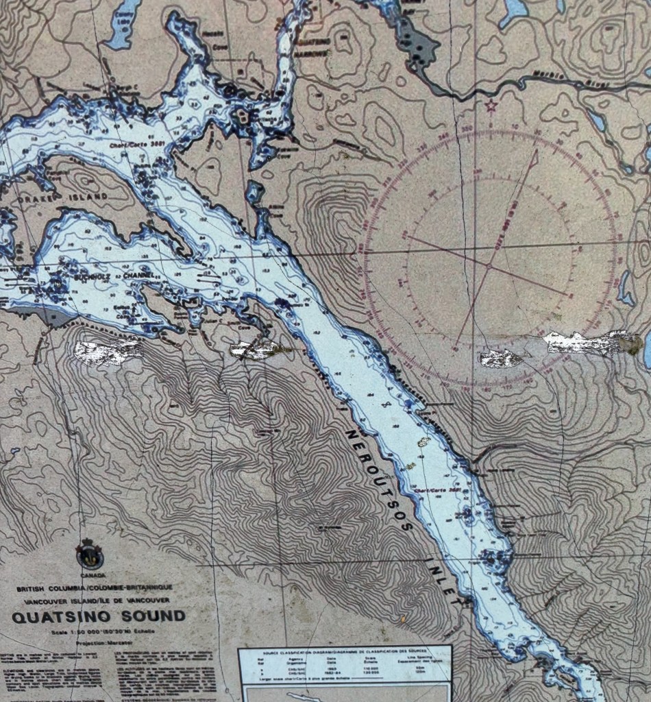
This body of water is the Neroutsos Inlet, named after Captain Cyril Demetrius Neroutsos.
Port Alice is in the lower right quadrant of the map above.
After taking my photos, and forgoing a side trip which the young ladies at the Visitor Center in Port McNeill told me about (on a long gravel and dirt road, too far off the paved road to attempt with all the logging trucks running around, to find the “Devil’s Bath”) I reversed course and headed back to Campbell River.
I came across this sign, which I had seen in another location not conducive to stopping to take a photo of it.
It reminded me of the many humorous road signs I saw when I traveled to Canada’s Maritime Provinces in 2019 (see multiple posts). I haven’t seen too many so far this trip but maybe I will when I start getting out into the countryside.
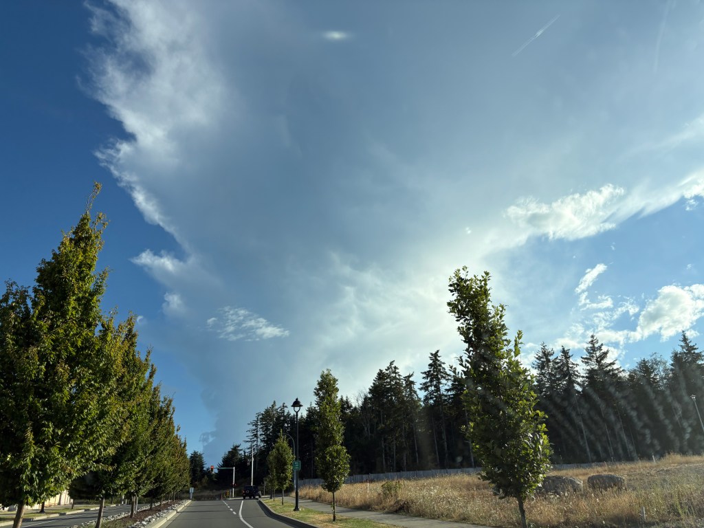
Shortly after I got home I went back out to take a photo of a helicopter I saw at the hospital the day I arrived in town, and saw this ominous cloud in the sky as I drove towards the highway. I knew it looked very different from other clouds in the sky that day.
Turns out it was the initial smoke plume from what became the Wesley Ridge Fire, further southeast down the island near Nanaimo. It was discovered around midnight the night before I took this photo and has grown steadily since then. It is near a small lake and many people have been evacuated from their homes. There was no visible smoke when I left early the next morning to drive to Nanaimo to take a ferry over to Vancouver but I could see the smoke at ground level once I got down there and could definitely smell it. Fortunately, no one has been injured fighting it.