Gila Cliff Dwellings – Post 2 of 2

May 29, 2017

My last full day in the Las Cruces area (southwest New Mexico) I headed northwest a little over 3 hours to visit the Gila Cliff Dwelling National Monument.  After driving in to the facility and parking at the Visitor Center I walked back a long path which took me on a gradual incline up to the side of the mountain where I could see and actually walk through the dwellings:

IMG_20170529_140851394_HDR

IMG_20170529_141310403_HDR

IMG_20170529_141737990

When arriving at the end of the tour everyone had the choice of going back the way they came in or climbing down a wooden ladder for a shorter path back to the parking area.

IMG_20170529_142046601_HDR

IMG_20170529_142127387_HDR

To give you an idea of the scale, there is a man standing in right portion of the photo above.

This post contains mainly earth-tones.  Here are some photos of a cactus with blooms to provide a little color.

IMG_20170529_163902144

IMG_20170529_163852593_HDR

IMG_20170529_163556540

Alamogordo, New Mexico area

May 28, 2017

The second day of my Memorial Day long-weekend stay in Las Cruces, NM I headed about an hour and a half northeast of Las Cruces to the Alamogordo vicinity. I had one specific destination in mind but discovered several other interesting things during the day so I was very happy I had the luxury of time on my side.

I had made a quick 4-day to trip to New Mexico back in 2014. I have a friend who lives in the central part of the state (his father was a tax client of mine) and I decided to fly out for a few days after tax season. My friend asked me what I planned to do while I was here and I rattled off about a half dozen destinations (including Alamogordo). There was a pause and Mark said “Uh, you realize those places are all pretty far apart?”. He was right and I never made it to Alamogordo, Carlsbad or Roswell – a situation I would resolve here in the next few days…

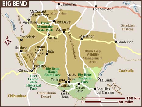
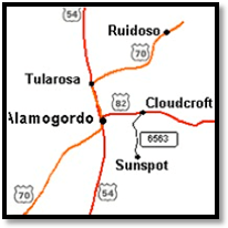
Anyway, today I drove past White Sands which I visited yesterday and continued up to Alamogordo. Once there I proceeded east a few miles to Cloudcroft, then south about 20 miles to the tiny town of Sunspot.

map_to_sunspot

(Photo credit: nsosp-dev.nso.edu)

Here I found the Sunspot Solar Observatory.

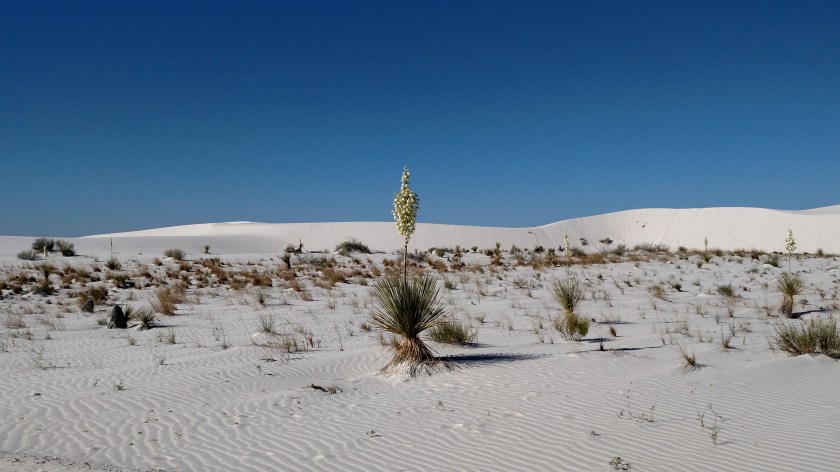
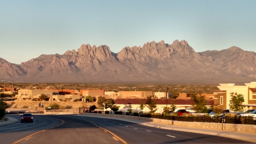
Here is the view as I ascended up the mountains towards Sunspot (elevation 9,147 feet). The white in the center portion of the photo below may appear to be low clouds but is actually White Sands National Monument!

IMG_20170528_110947094

Here are some of the things I found when I arrived at the Solar Observatory:

This is the main telescope, used to study the sun:

IMG_20170528_114254916_HDR

The visible part of the telescope enclosure rises 136 feet above the ground. Like an iceberg, however, this instrument is located mostly under the surface! The telescope inside the white enclosure continues down 193 feet underground.

IMG_20170528_114531393.jpg

Elsewhere on the property is a solar telescope originally located at the South Pole.

IMG_20170528_113350925

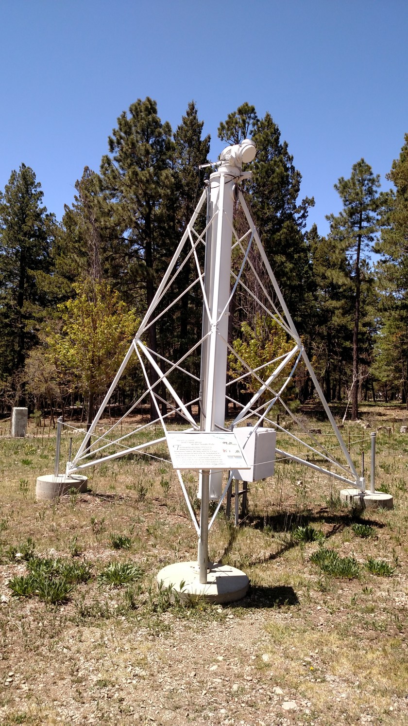
During “summertime” down there the sun is above the horizon 24 hours a day so scientists have lots of time to study it (and the atmosphere isn’t as disrupted). There is now a much more modern and sophisticated solar telescope at the South Pole.

The Sunspot Solar Observatory was in the news in September of 2018 when the FBI mysteriously swooped in and told all the employees they had to leave the property immediately. They kept the facility closed for about 10 days and were very tight-lipped about what was happening. Theories ranged from aliens, a chemical leak (various gases are inside the telescope enclosure) or a terrorist threat. Turns out it was nothing quite as unusual or scary as those things. Seems a janitor at the facility was using their computers to collect and distribute child pornography!

As I was leaving the Observatory I saw signs for another facility, the Apache Point Observatory, just up the road. That facility is private so there is no public access but I did see this photo outside the gate which shows some of the telescopes there:

IMG_20170528_120230878

Among other things, this facility uses lunar laser-ranging to measure, with millimeter level accuracy, the precise distance to various instruments on the moon.

As I drove back to Alamogordo I stopped at “The Lodge,” a beautiful hotel in Cloudcroft which has hosted many celebrities and is rumored to be haunted.

IMG_20170528_105500152_HDR

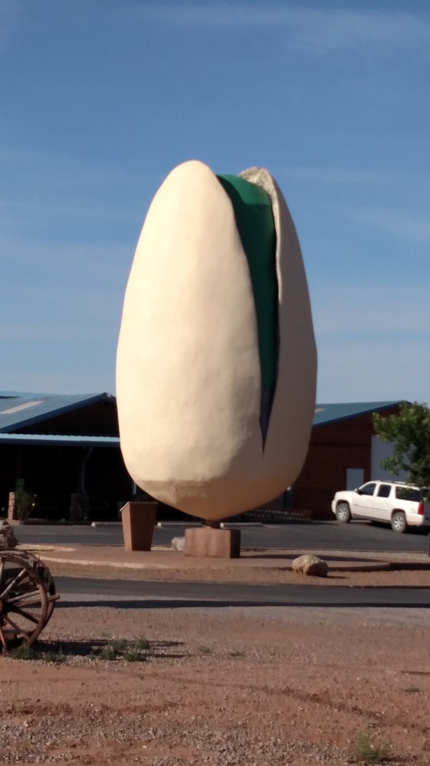
Lastly, the Alamogordo area is home to many large farms which grow pistachio nuts. I stopped and sampled many flavored varieties and bought a few pounds (which didn’t last long!).

IMG_20170530_082142600

I headed back to Las Cruces, drove down to La Mesilla for dinner and I got home in time to watch the Coke 600 race from Charlotte. A very full and rewarding day!

White Sands National Monument

May 27, 2017

My first full day in Las Cruces, New Mexico I headed about an hour northeast on Route 70 to spend some time at White Sands National Monument, a 224 square mile area on the southeast end of the massive White Sands Missile Range.  I had stopped here briefly back in 2014 when I made a very ambitious tour of New Mexico (a story I will share in a future post) and had only spent a few minutes at White Sands.  Today I had more time to enjoy the area.

IMG_20170527_084010090

IMG_20170527_084040988

IMG_20170527_084434113

IMG_20170527_084530281

IMG_20170527_084940762

IMG_20170527_085055528_HDR

IMG_20170527_085104055

IMG_20170528_084911701

While I was stopped in one of the parking areas I spotted the same guy I had spoken with about a week ago while visiting the Marfa Lights Viewing Center.  He was parked in an adjacent parking area with shelters for primitive camping, which he was doing during his driving tour of the western US.  He lives in Pennsylvania and drives a distinctive orange Jeep with a red kayak on top.  I marched across the sand dunes to say hello (again) and marvel that I had now seen him twice in one week.   Small world…


Las Cruces, New Mexico

Memorial Day weekend, 2017

I would be spending 4 nights in Las Cruces and as I did in Alpine, Texas, chose the city for it’s strategic location to things I wanted to visit while I was here.  I actually spent very little time in Las Cruces (a beautiful town), only being there to sleep, eat and watch the two big NASCAR races held in Charlotte, NC (on TV.  I confirmed the fact that I could watch the races while I was here when I made the reservation).  The young couple I stayed with had lived in the Charlotte area for a number of years so they understood my NASCAR obsession.  They had a beautiful new townhouse on the northeast side of town and were the ones who told me about Meow Wolf, a funky art complex in Santa Fe, NM which I’ve posted pictures of in the past.

This was the view as I approached my Airbnb the night I arrived:

IMG_20170526_193815432_HDR

And here is a map of the area to get your bearings:

Las-Cruces.8

(Photo credit: weather-forecast.com)

Not sure why El Paso isn’t on the map (it is just to the right of Ciudad Juarez, on the United States side of the Rio Grande river.  CJ is in Mexico).  The city of Las Cruces is shown by the red dot in the center of the map.  Other places I will be visiting while in the area are White Sands National Monument (above the highway between the two occurrences of the words Las Cruces), Alamogordo (above the higher words Las Cruces), the Gila Cliff Dwellings (due north of Silver City on the left side of the map) and Hatch, located just northwest of the red dot.

After checking in at my Airbnb I headed back out to an area southwest of town called Old Mesilla Village (aka La Mesilla).  Most of the restaurants which were on my short list were located there, as well as many historic buildings and the San Albino church:

IMG_20170527_150934772

There were some interesting birds in huge cages at the restaurant I chose to eat at the night arrived and I’d be back down to Old Mesilla Village several more times during my stay.

IMG_20170526_183720432

IMG_20170526_183858609

Old Mesilla Village was a beautiful place to walk around in the evenings and I highly recommend checking it out if you are ever in the area.

IMG_20170526_184335701

One day I drove south of La Mesilla on one of my scenic roads and saw acres and acres of pecan groves:

IMG_20170527_162317853

There were also many places where avocados were being grown.

El Paso, Texas

May 26, 2017

Well, I finally made it!  About 220 miles west of where I had been staying in Alpine for the past few nights, and after wrapping up some loose ends over that way in the morning, I continued west on Route 90 to where it intersects (the dreaded) Interstate 10 and eventually planned to pass through El Paso, which is as far west as you can go in the state of Texas (having entered the state about as far east as you can go), on my way to Las Cruces, New Mexico (about 45 miles further up the interstate) where I would be staying for the next 4 nights.

Because of my loose ends earlier in the day it was a little after 3 o’clock local time when I arrived in the El Paso area and, seeing as this was the Friday going into Memorial Day weekend, I checked my AAA TourBook (at a highway rest stop, not while I was driving) and decided to get off the highway to avoid rush hour and see a little bit of downtown El Paso.  That turned out to be an exercise in frustration for two reasons – first, they were doing street construction and I had no idea where I was and at times I couldn’t go where my GPS was trying to guide me.  Second – the city was preparing for a big Memorial Day celebration and had other streets closed as well.  Not a good combination.

Well, after parking a few blocks away  and continuing on foot I did finally make it to my primary goal – the El Paso Museum of Art.

IMG_20170526_152505454

IMG_20170526_153506641

IMG_20170526_153607949

IMG_20170526_153803302

IMG_20170526_153906755

IMG_20170526_153845971

IMG_20170526_154035681

Prada Marfa

May 26, 2017

FortDavis area

(Photo credit: lonelyplanet.com)

The day I left Alpine to head further west I first drove up to the McDonald Observatory, drove the scenic loop west of it back to Fort Davis, then proceeded southwest to the little town of Marfa. This trip was pre-blog and I was sending some of the pictures I am now posting to friends back home in real time. When my friend Kathy learned I would be in Marfa she told be to be sure to check out Prada Marfa, without explaining any details.

For those of you who don’t know, Prada is a very high-end women’s apparel and accessories retailer with locations in many shi-shi places around the world. Silly me assumed it would be in the town of Marfa and while I was there I drove around looking for it. I didn’t ask anyone and just assumed it didn’t cut it in little Marfa (all the while wondering why in the world they would have one out here in the first place).

Today was a travel day and I was heading west to El Paso, Texas and ultimately Las Cruces, New Mexico where I would be spending the next few nights. Lo and behold, as I traveled west on Route 90, there it was – all by it’s lonesome out in the desert (actually closer to the town of Valentine than Marfa).

IMG_20170526_122524552

IMG_20170526_123136372

Like any real Prada store there are actual Prada shoes (right shoes only, mind you) and handbags within this locked facility.

IMG_20170526_122326757

IMG_20170526_122340458

It was created in 2005 and has been robbed or vandalized several times since then.

It’s actually quite a hoot.

McDonald Observatory

May 26, 2017

Earlier in the week I drove up to McDonald Observatory, a little over an hour north of where I was staying in Alpine, and the day I left the area to head further west towards El Paso I had time to make another trip up there to take some day photos and drive the scenic loop again, in the opposite direction from the way I had driven it earlier.  When time permits I’ve learned that traversing a road in a different direction and perhaps a different time of day affords me the opportunity to see different things.

First, the Observatory.  McDonald has optical telescopes so it is only used at night.  It sits at an elevation of over 6,000 feet and benefits from the usually clear Texas night sky.  Since it is in a less populated part of the state it also enjoys a low level of light “pollution”.

IMG_20170526_100008339_HDR

IMG_20170526_100458327

Below is the outdoor amphitheater, where the host explained what we’d be seeing during the “star party” Tuesday night before we made the rounds of the telescopes themselves.  While he was speaking the International Space Station passed overhead (talk about perfect timing!) and he also pointed out an abandoned Chinese space station which, as it turns out, was de-orbited under controlled circumstances and brought back to Earth in 2018.

IMG_20170526_100412349_HDR

Here is a model of what an older technology telescope looks like inside the “shell”.

IMG_20170526_101346672

The shell can rotate to observe different areas of the sky and helps protect the instruments from the elements.  Here is a photo of a photo of one of the actual telescopes at McDonald:

IMG_20170526_101457873

This facility owns and operates one of the largest optical telescopes in the world.

The night I attended the “star party” we looked through about a dozen telescopes, including several of the ones pictured closest to the Visitor Center, as well as several free-standing ones which volunteers had set up in the area.  We saw mainly clusters of stars (the volunteers explained specifically what we were looking at) and one of the large scopes was pointed toward the planet Jupiter, and I could clearly see the planet and several of it’s moons.  One thing I did not see was the great “red spot” which was on the opposite side of the planet.  As big as it is, Jupiter rotates once every 10 hours or so.

After getting pictures at the Observatory I made another lap around my scenic road, drove southwest to Marfa and started heading west towards El Paso.

While making the scenic loop I saw this sign:

IMG_20170523_184453802

This was one of the first times I encountered this but would experience it many times during my trips out west (of which this was the first).  Many large ranches let their cattle roam free-range.  While there is a long fence perimeter to keep them on the property they can walk around pretty much where they want, which of course means they must from time to time cross the road (to get to the other side).  To prevent them from making a run for it there are cattle guards to prevent them from sneaking out on the driveways or other roads on the ranch or, if they are on the paved road, from wandering past the fenced-in perimeter.

IMG_20170526_090803710

When driving in these zones, however, you must always be vigilant for cattle, horses or bison on the road.  They are generally reluctant to move and if you hit one it will probably ruin both of your days.

IMG_20170526_091842204

I will say that of my three major trips out west I saw far more cows in the road than anything else.

The Marfa Lights

May 25 & 26, 2017

Despite my fairly extensive pre-trip research I didn’t learn about this phenomenon until I arrived in Alpine and studied a tourist map of the area and saw something showing as “Marfa Lights Viewing area”.

BigBendNatlPark

(Photo credit: nps.gov)

On Thursday May 25 I did quite a bit of driving on scenic roads in the area and ended up in Marfa, a small town about 26 miles west of where I was staying in Alpine. Having now read about the Marfa Lights online I thought I’d head out there after dinner to check it out for myself. I had stopped at the facility along highway 90 during the day and spoke with someone who had his Jeep parked there and was planning to be there after nightfall. There is actually a well-marked Marfa Lights Viewing Center (MLVC) a little more than halfway between Alpine and Marfa.
I broke my “no driving after dark” rule for the second time in three days – really letting my hair down out here in rural Texas – and when I arrived at MLVC after dark there were already quite a few people there (around 40, as I recall).

Here are photos I took the next day:

IMG_20170526_081721697_HDR

The structure at MLVC actually only houses restrooms, built in a yin and yang shape when seen from overhead. Behind the building is a paved viewing area with a low stone wall around it (to keep critters like snakes and scorpions out – hopefully…).

IMG_20170526_081810335

IMG_20170526_081806837

IMG_20170526_081827620_HDR

From the MLVC humans are supposed to look out over the desert southwest, towards Route 67, which runs north to south, and the Chinati mountains on the other side of that highway. If you look very closely you’ll see a Chinati mountain peak between the two utility poles in the photo above. After dark there is a telephone tower in the distance with a red light on top of it which spectators are informed is a good reference for seeing the lights, generally to it’s right.

Reports have said people often see lights flashing on and off or remaining stationary, and on occasion zipping from side to side or traveling in “packs”.

I stood there for over an hour (well after dark) and yes, I did see stationary or slightly moving blinking lights, generally in the same area. Most times it was a short burst but on occasion it lasted a little longer. There were oohs and ahhs from the crowd when the lights first appeared. I didn’t see any “zipping” along the horizon, nor did I see anything which I would remotely consider extraterrestrial. Information online seems to indicate that the lights are usually very low, near and below the horizon. Color me skeptical but now that I’ve seen at least an hour’s worth of “Marfa Lights” I don’t think you need to be a rocket scientist to surmise that what you are seeing is probably lights from vehicles on a highway (Route 67, duh) perhaps being caused to flash by passing behind trees or other roadside obstacles. I think it’s all a bunch of hooey.

As I was driving out to the MLVC that night I got excited when I did see three bright lights coming towards me. Turns out it was a train on tracks parallel to the highway!

Move along, folks – nothing here to see…

Cactus! Post 1 of 2

May 25, 2017

I started the day driving north from Alpine towards Fort Davis to stop at a facility I had seen the day I arrived in the area but didn’t have time to visit – the Chihuahuan Desert Nature Center:

IMG_20170525_111726151

Here is a map of the total area covered by the Chihuahuan Desert:

IMG_20170525_095735959

Fort Davis is located in Texas,  west southwest of Fort Stockton.

The Nature Center and Botanical Gardens had a wide variety of full sized plants outdoors on a nice walking path.  What intrigued me even more (and provided better photos) were the wide variety of young plants located inside the greenhouse.  All the plants you are about to see are native to the Chihuahuan Desert.

IMG_20170525_093539112

IMG_20170525_093557781_HDR

IMG_20170525_093650260

IMG_20170525_093657532_HDR

IMG_20170525_093723385_HDR

IMG_20170525_093730676

IMG_20170525_093818636_HDR

IMG_20170525_093910660

When I was finished at the Nature Center (more photos in Post 2) I returned to Alpine, then continued south to make a large clockwise loop on a series of scenic roads.

Yesterday I drove to and through Big Bend National Park before returning to Alpine (335 miles total for the day). Today I traveled south on Route 138 (which I had driven north on the previous afternoon) to Terlingua, then west through Big Bend State Park to the town of Presidio (on one of my primary scenic roads), then north on Route  67 to Marfa.  What I did there will appear in another post.


FortDavis area

Total mileage for the day – 326 miles.