Lassen Volcanic – Post 1 of 2

Wednesday morning I drove about an hour east of where I had been staying in Redding, California to visit Lassen Volcanic National Park.  This Park was the main reason why I left the coast of northern California and traveled inland (only to be greeted by 100+ degree temperatures!).

Lassen Volcanic National Park was created by Congress in 1916 after a series of volcanic eruptions of Lassen Peak in 1914 and 1915.  Scientists and seismologists are particularly interested in Lassen because it is one of the few places in the world which contains all four types of volcanic, or hydrothermal, formations.  They are Composite (or stratovolcanoes), Shield, Plug domes, and Cinder (or Scoria) Cones.

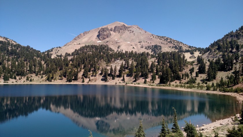
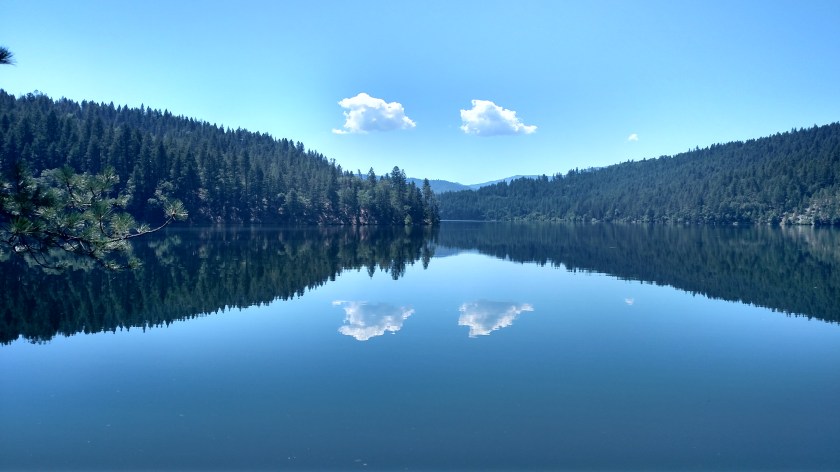
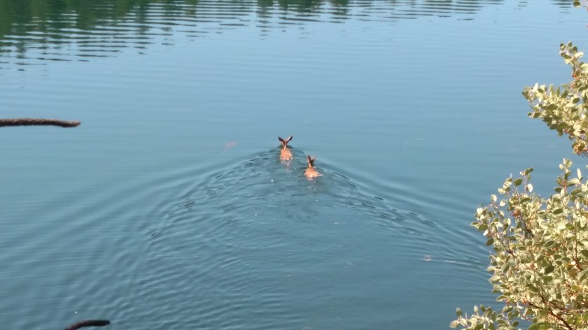
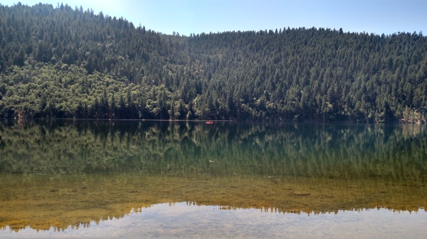
I arrived at the northwest entrance of Lassen at around 830am local time and the Visitor Center didn’t open until 9 so I had time to take a leisurely walk around Reflection Lake:

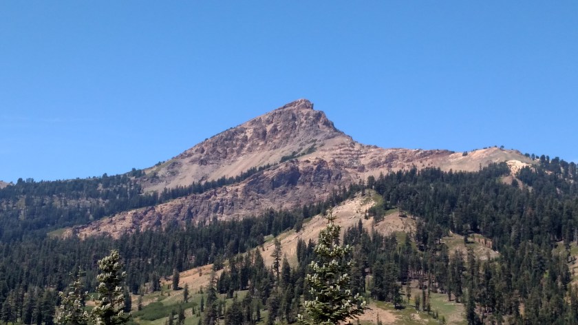
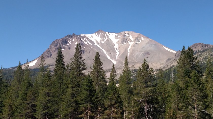
This is Lassen Peak.  It now has a maximum elevation of 10,457 feet.  The park entrance is at around 5,000 feet elevation and most of my time in the Park was at that elevation or higher, so the temperatures most of the day were very pleasant compared to what I experienced while in Redding.

IMG_20180718_090020706_HDR

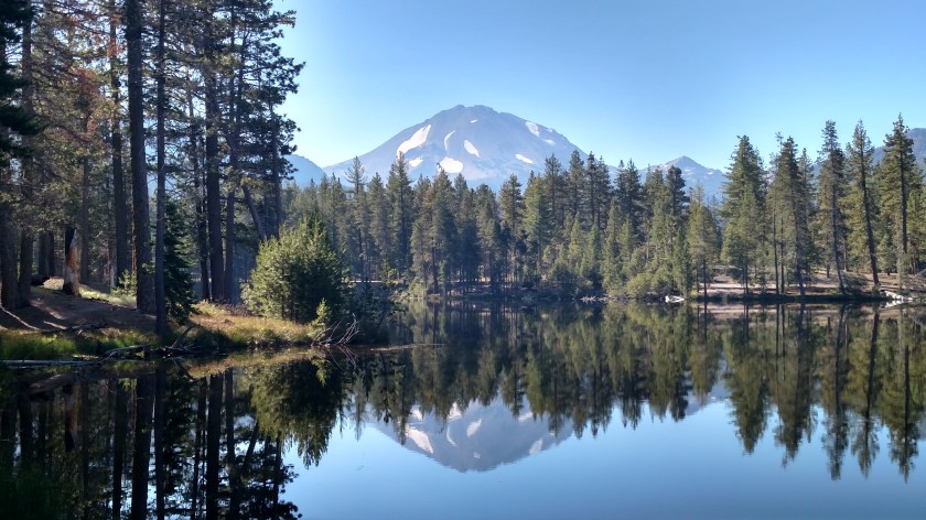
Walking around the lake you can now see formations called Chaos Crags to the left of Lassen Peak.  While they appear to be about the same height they are actually shorter (only 8,530 feet) but are much closer to where I was taking these photos.

IMG_20180718_090356756_HDR

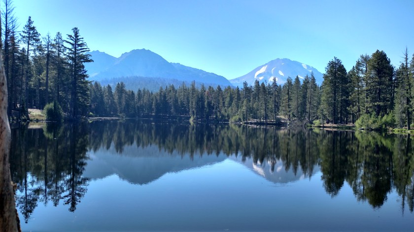
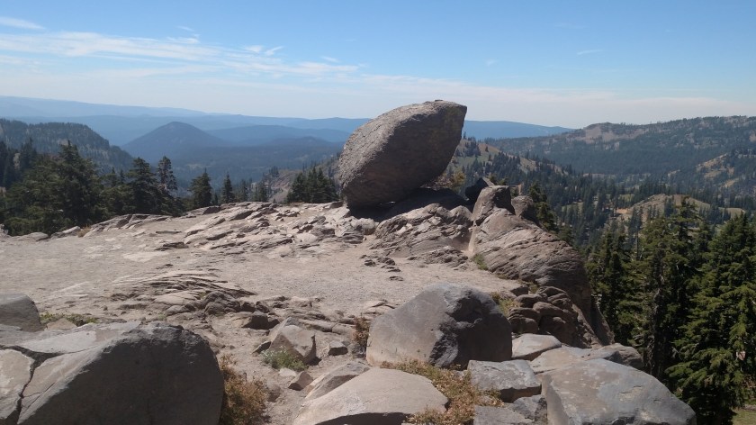
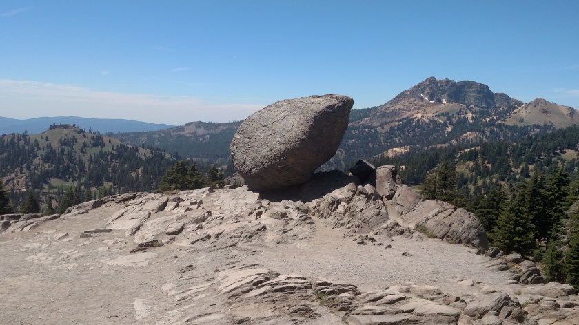
And here are just Chaos Crags (actually a series of 6 “plug dome” volcanoes).

IMG_20180718_090516265

IMG_20180718_090748582_HDR

I then went to the Visitor Center and learned more about the history of the Park.  To look at a map of Lassen, Google “NPS Lassen Volcanic Map” and on the first page you will see the brochure map which you may then print locally.  The main, paved road only curves through the westernmost side of the Park.  As was the case at Yosemite, Sequoia and Kings Canyon Parks, which I visited earlier this trip, I can only see a very small percentage of the Park from the main road and to get to most areas you must hike (which I don’t) or travel on unpaved roads (which I am reluctant to do).  I should also mention that, generally on the eastern side of this and the 3 Parks mentioned earlier, the Pacific Crest Trail, a 2,600 mile-long trail similar to the “Appalachian Trail” in the East, traverses these Parks taking hikers north and south along the western side of the country, from Mexico to Canada.

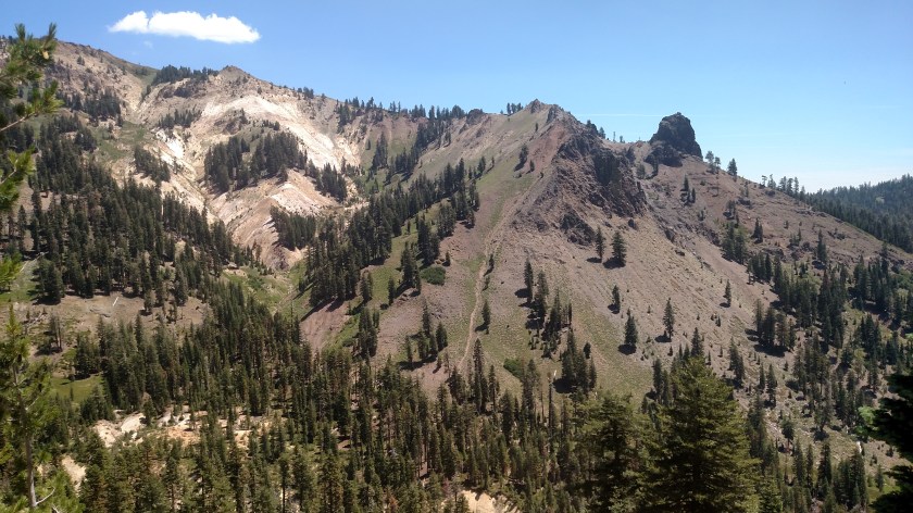
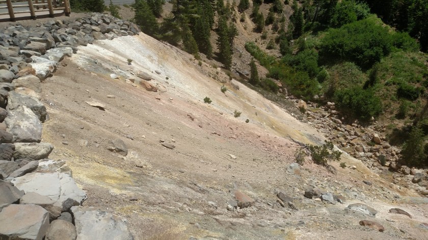
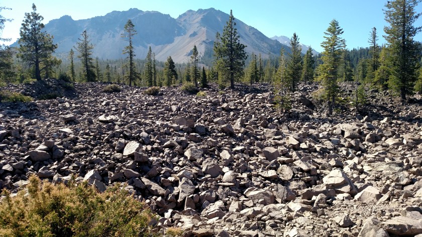
I left the Visitor Center and the first place I stopped at was Chaos Jumbles, a huge rockfield created over 300 years ago by a series of avalanches which resulted from the collapse of the northwest face of Chaos Crags.  The thing that impressed me the most about this was the incredible distance these (substantial) rocks traveled just by the massive force of the avalanches.  The initial release traveled more than 4 miles and stopped only after CLIMBING over 400 feet on another hillside!

These rocks came from Chaos Crags, which is in the distance.  The rockfield continues a considerable distance behind this vantage point as well.

IMG_20180718_093904232

Further up the road I came to the “Devastated Area,” this one caused by the series of eruptions of the northeast face of Lassen Peak just over 100 years ago.

IMG_20180718_102831954

IMG_20180718_102842773

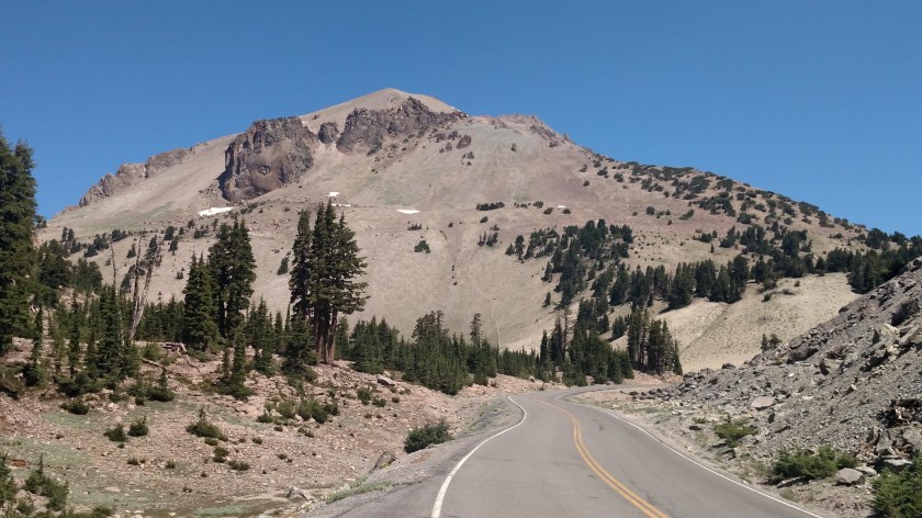
I continued on around the Lassen Park Highway until I got to the closest point the road gets to Lassen Peak (and also the highest point the road reaches, at 8,511 feet).  This was the snow still on the ground just off the left side of the road:

IMG_20180718_113130974

I was now looking at the “backside” of the mountain which gets longer exposure to the southern Spring and early Summer sun and no longer has much snow left on it.

IMG_20180718_113713514

But I did have a very nice view looking down at Lake Helen, with Mount Diller and Pilot Pinnacle off in the distance:

IMG_20180718_113526855


Lassen Volcanic – Post 2 of 2

Here are more photos I took Wednesday at Lassen Volcanic National Park in northeast California.

This is looking back at Lassen Peak after driving down the hill and around to the other side of Lake Helen.

IMG_20180718_114021343

And this is a closer view at Mount Diller and Pilot Pinnacle.

IMG_20180718_121552590

This huge rock (I should have gotten pictures when there were people out taking photos near it) was at a scenic overlook (out here they call them Vista Points) near an area called “Bumpass Hell.”  That area is now off limits to hikers as the Park Service is making repairs and improvements to the trail leading to it.  Bumpass Hell, named after Kendall Bumpass – the man who discovered it, is a series of mudpots, fumaroles and sulfuric springs similar to what I saw last year at Yellowstone National Park.

IMG_20180718_121616380

IMG_20180718_121638256

This was a hillside further down the road.

IMG_20180718_123649833

IMG_20180718_123714882

This is Brokeoff (not Brokeback!) Mountain, what’s left of the Brokeoff Volcano which erupted approximately 600,000 years ago with a force estimated to be 50 times that of the Mount St. Helens eruption in 1980.

IMG_20180718_124544447

And shortly before leaving the Park at the southwest entrance I stopped at the “Sulphur Works,” an area similar to Bumpass Hell but located right next to the road.

IMG_20180718_125305405

This is a mudpot.  It is much more interesting to see in action (I took a short video but can’t post it on the blog).  A mudpot is a bubbling pond of hot, gray water (bubble, bubble, toil and trouble…) and releases a pungent sulphur , rotten egg, odor.

IMG_20180718_125308718

These sulphur formations often leave very colorful side effects.

IMG_20180718_125519926

And this was taken from a vantage point near the southeast shore of Lake Almanor, about 30 miles from the Park as I headed south towards where I am staying in Quincy, CA.

DSCN3515

Thursday – Wildfire and Travel Updates

No photos.

Yesterday I traveled over to Lassen Volcanic National Park, about an hour east of where I was staying in Redding, California.  I entered the Park through the northwest entrance and left via the southwest entrance.  I am planning to go back up to the Park today (I am now staying in Quincy, CA, south of the Park) but as I check the InciWeb Wildfire website I see that the L1 Spring Fire was reported yesterday afternoon around 230, close to the south entrance.  It was initially reported as only 12 acres and there isn’t an update yet this morning (I am posting this at 550am local time).  Hopefully I can still get in the south entrance and I was already planning to get back to Quincy via an eastern route and not the way I came down here yesterday.

At Yosemite National Park the Ferguson Fire in still causing big problems.  A firefighter lost his life last weekend when the bulldozer he was operating overturned, crushing him underneath.  He was an experienced operator, clearing brush to create a “fire break” line.  That fire has been particularly stubborn as it is in a difficult to reach area and retardant dropped from aircraft is ineffective because the tree canopy prevents it from reaching the ground.  Visibility at Yosemite is not good, nor is the air quality, as the smoke it pretty much staying in the area.  Weather forecasts for the area are not favorable for improvement.

When I leave Quincy tomorrow morning I’ll he heading north on a series of scenic roads and crossing the state line into Oregon, staying in Klamath Falls over the weekend (I had my tires rotated there last year one of the days I visited Crater Lake).  I have been keeping an eye on the Klamathon Fire but, while substantial in size, it is located well west of the town I’ll be staying in.  It remains to be seen what effect that fire will have on the areas I plan to visit while up there.

About a week and a half ago I stayed in Ukiah and there had been a fire close to there but I saw absolutely no indication of it and didn’t notice haze or any smoke odor.  I am keeping track of a few small fires in Oregon, where I’m headed next weekend after wrapping up my time in California.


And I heard last night that Scenic Route 1 south of Monterey has now reopened after last year’s devastating landslide.  Because of favorable conditions this Spring they were able to complete the road reconstruction ahead of schedule.


I am reviewing photos from Lassen Volcanic National Monument now and plan to post them before I leave for the Park later this morning.

Redding, California area – Various

Monday I drove from where I had been staying in Arcata, north of Eureka, over to Redding, about 140 miles inland.  It was 63 degrees in the morning at the Arcata Marsh (which I haven’t posted about yet) and it was 106 when I got to Redding!  Sweet revenge, Durham – the shoe is finally on the other foot.  On the way over I stopped briefly at Whiskeytown Lake, a major part of the Whiskeytown National Recreation Area.

IMG_20180716_153118443

There is a town of Whiskeytown but I haven’t been to it yet.  I will be passing through Redding again in about a week and a half on my way back out to the coast.

When I got to town I stopped for something to eat and saw this vintage AMC Pacer (XL Wagon, thank you very much) parked outside.  It looks to be original and not a restored car and was in great condition.

IMG_20180716_160052069_HDR

IMG_20180716_160105327_HDR

I have seen a surprising number of older cars in relatively good shape for their age during my trip.  I wished I had my camera when I saw what I’m sure was a 1960’s era Mercury Comet in an El Camino format (I think Ford/L-M may have called theirs “Ranchero’s”)  back when I was staying in Sonora.  It was driving down the road when I was in the vicinity of the Marine Training Facility.

Tuesday it was forecast to reach 109 degrees (and the highest I saw this afternoon was actually 112) so I went out early to the Sundial Bridge, then sought out a city park to make my plan (in the shade) for the day.

IMG_20180717_090922619_HDR

IMG_20180717_090938799_HDR

There were already kids at the pool in the park.

IMG_20180717_091255960

There was also a really neat bicycle path with various obstacles and ramps which two little kids were riding their bikes on.  I wanted to get pictures but I was already getting dirty looks like I was a pedophile so I opted to pass.

After studying my materials on the area I decided on two scenic drives, one to Shasta Lake and the other to Trinity Lake.  Because I forgot my digital camera when I left the house this morning I had to double back there in the afternoon.  Around 3pm I decided to get another haircut (I just had one a month ago but they left too much on top and it’s been driving me crazy).  Today they did a good job on the top but left too much on the sides….  I miss you, Susan!!

This was the scene at Trinity Lake around mid-day:

IMG_20180717_121124925

IMG_20180717_121109088

IMG_20180717_121141257

IMG_20180717_121204635

IMG_20180717_121225135

IMG_20180717_121229874

The banks at this lake (actually a reservoir for Sacramento) looked low to me but I stopped at a resort on the north side of the lake and the young lady I spoke with there, Shannon, said this year is actually pretty normal.  Last year was a higher than average year but this year they are strategically lowering the lake based on a surprising set of priorities (local Native American tribe rules, the need for power generation and, lastly, recreation).  They have already gotten most of what they’ll get from snowpack melt so they must carefully control the lake level.  They are way short on rain this year.  According to information at Shasta Lake this year-to-date there has been 40 inches of precipitation versus 99 inches for the whole year in 2017 (higher than normal).

This is what one part of Trinity Lake looked like as I was leaving the area.

IMG_20180717_131123106

I also saw a boat launch area which was completely dry with the boat ramp hanging in the air with concrete barriers in place so people don’t accidentally drive off.


The Shasta Trifecta

This morning I decided to drive from Redding, CA up to Shasta Lake – a very short drive on a nice scenic road.  When I got there I could get three Shastas all in one photo:

IMG_20180717_151359503

In the foreground in the Shasta Lake Dam.  Behind it, as you have probably guessed, is Shasta Lake (or Lake Shasta, as some prefer).  And way off in the background (above and slightly left of the 5 pipes on the left side of the photo) is Mount Shasta.  I left my digital camera in my backpack back in town so I had to go get it and drive back up here in the afternoon to get these closeups of the mountain:

DSCN3505

The white cloud kind of sticks up above it, emulating the peak.

DSCN3512

The surface of the lake is at 1,067 feet elevation.  Mount Shasta tops out at 14,180 feet, which is one reason why it still has snow on it on July 17th!

Here are some more photos of the lake, some taken this morning and some this afternoon.

IMG_20180717_100354440

IMG_20180717_101052560

IMG_20180717_101209628_HDR

This little guy (stuffed) was in the Visitor Center.  It is a Ringtail Cat.

IMG_20180717_101955490

They also had this 3-D map showing the three lakes in the area I’ve been to see – Whiskeytown, in the lower left hand corner, which I stopped at briefly on my way in to town yesterday, Shasta, in the right half of the photo, and Trinity, in the upper left corner, which I will make another post about.

IMG_20180717_103018627

They also had some awesome Osprey pictures taken by a local photographer.  I am reaching out to her to get permission to post some of her amazing pictures (I’d rather post from her website than the pictures-of-pictures I took).

I took these photos of Shasta Lake this afternoon when I returned with my digital camera.

IMG_20180717_152845355

IMG_20180717_152851916

The Dam took four years build, employing 3,500 men working in shifts, 24-hours a day.  The first yard of concrete was laid on July 8, 1940.  A conveyor belt 9.6 miles in length was constructed between Redding (where I’m staying) and the lake which at the time was, and may still be, a world record.  It was used to transport 12 million tons of sand and gravel for construction of the Dam.

Damn!

Right place, right time…

… or just chalk it up to dumb luck.

I went for a drive on a scenic road west of Redding this morning and turned on a small road (because there was a directional sign to my destination) which was actually several miles before the one I intended to take.  I stopped and looked at my map and it appeared they would both get me where I was going so I stayed on the “wrong” road and decided I’d come back on the other, more major, route.  It’s a good thing I did that or you wouldn’t be seeing these next photos.

I already posted one “mirror image” picture earlier today (prior post, “From the walking path along the river”).  Well, as I was driving north on this small road, headed for Trinity Lake, I got a brief glimpse of another body of water off to my right.  I turned around and went back to “Cooper Gulch” and this is what I saw after I went down to the parking area:

IMG_20180717_114646819_HDR

Further up the road there was a tiny fawn in the road (it still had lots of spots), standing in my lane.  I stopped and let it run into the woods (and after I drove past I saw Momma deer cross the road too).  Shortly after that I stopped at a pullout area because I saw a lone kayak out on the lake and wanted to get a picture.  While getting in position I looked down towards the lake and saw this – a first for me.  Two deer “swimming” out into the lake!

IMG_20180717_115311785

They appeared to be adult does and weren’t panicked, just taking a leisurely swim (although they probably started because they heard me pull off onto the gravel).  I was surprised they made such good forward motion with their skinny legs (unless they remembered to pack their little deer-flippers).

IMG_20180717_115334178

And Mr. Smiley-pants JohnBoy left his digital camera in his backpack at the Airbnb in Redding so I had to drive further up the road to be able to see the kayak in the smartphone picture (red, in the center of the photo):

IMG_20180717_115705112_HDR

Clearly it’s “mirror image” day here on the blog!

The Sundial Bridge

It is 718am local time here in Redding CA and I am sitting here looking up at the Sundial Bridge.

This was before I walked across it.

The bridge spans the Sacramento River.

The gnomon (I think that’s Latin for “pointy-thing”) casts a shadow which can then be used to tell you what time it is.

IMG_20180717_070235984

Those markers are in 15 minute increments along the shadowy path of the gnomon (about 5 1/2 paces apart).  You can see three of them in the next photo (only whole hours are on raised platforms).

This is my view as I am uploading this post.

My Airbnb Experience in California

I must say that I have an amazing string of excellent Airbnb experiences running. While the vast majority of places I have stayed over the past four years have been fantastic, the past month or so has really been exceptional. And I use the term “experiences” as it is much more than just a place to stay. The people who host play a huge role in the success of a stay and their attitude and input (maybe better to say dialogue) really makes or breaks a stay.

I have made a few posts about specific venues but want to take a few moments to recap the past month in California.  I hope you will indulge me.

Visalia – After my stays in Pahrump and Yucca Valley, the week I stayed with Chris and Nicole in Visalia was what really started to build the momentum of my wanting to make this post. This young couple, both teachers, really opened up their home to help me feel welcome, as their reviews indicated they have done with many guests before me. We had many interesting conversations during the week I was there. They are both very intelligent and articulate, and we covered many topics.

Sonora – My week with Barry and his wife Jeri really felt more like a week at a family reunion. This older couple has an absolutely gorgeous home which you can tell is an accumulation of family memories as well as reflecting their personal interests.  Barry’s local knowledge and suggestions for things to see and do which weren’t on my radar was invaluable.  The three of us also had many interesting conversations.

San Rafael – My week with Julia was terrific. She invited me to join her July 4th cookout in her spacious backyard:

IMG_20180708_164033598_HDR

IMG_20180708_164038109

IMG_20180708_164041840

Evenings the rest of the week I often spent sitting outside in the shade (where I took these photos) waiting for the large, green hummingbird to come feed on the purple flowers.

DSCN3124

DSCN2907

DSCN2911

DSCN3075

I didn’t realize it at the time but this is actually a different hummingbird.

DSCN3089

DSCN3103

And one day as I was carting stuff outside I noticed the orchids Julia was growing on her indoor porch. I have a particular interest in orchids after having read all the Nero Wolfe books written by Rex Stout. Wolfe is a fictional detective in 1940’s and 50’s Manhattan who had a personal orchid nurse on staff and had 10,000 orchids in the third floor greenhouse of his brownstone.

IMG_20180708_173922780

IMG_20180708_173942330

IMG_20180708_184949065_HDR

IMG_20180708_184903743

IMG_20180708_185002858_HDR

Ukiah – My three night stay in Orell’s home was great and felt like being at home in North Carolina.  I didn’t get to interact with him very much during my stay but enjoyed visiting with some of the other Airbnb guests.

Arcata – I am wrapping up three nights here in Arcata and today will be moving on, inland to Redding on my way to visit Lassen Volcanic National Park for a few days. While I have been spending a lot of time at the coast the last week and a half the forecast for today and tomorrow in Redding are for temperatures of 106 and 109 respectively. Ouch. I have been spoiled by temps in the mountains generally in the 70’s and low 80’s (nice), and at the coast in the 60’s or 70’s (VERY nice). Well, Redding is in the valley (as Ukiah was) and temps there can get a little toasty. I was surprised when I saw this 3-D map of California when I visited the Bay Model in Sausalito:

IMG_20180705_153925765

IMG_20180705_153911961

I never realized that California basically has mountains all around it’s edges. Internally (from below the Napa Valley all the way up to where I am now in Northern California) temperatures are often much more intense than other parts of the state because it is a relatively flat valley at low elevation.

I may spend the majority of the day here in Arcata/Eureka before heading to Redding this evening (it is only 140 miles away). Then it will be back to shorts and t-shirts and will put the long pants and sweatshirts away until I get back out to the coast in Crescent City and head north to Oregon.

Sausalito Sunday, et al

Sunday, July 8 I started my day by going back in to Sausalito, California which wasn’t very far from where I was staying in San Rafael.  When I left town a few days earlier I discovered a whole area facing San Francisco which I didn’t know existed.  I also wanted to go to a taco shop which had been highly recommended but which wasn’t open the day after the 4th of July.

The taco shop didn’t open until 11 so I killed some time down by the marina.

IMG_20180708_104520175

IMG_20180708_104537253

IMG_20180708_104605951

These were at the taco shop where I had lunch.  They reminded me of a metal car with a surfboard on top that a friend of mine gave me when he learned how much I like to drive.

IMG_20180708_111634853

IMG_20180708_112408449

As I was walking back to my car I passed a very fragrant plant which I found very pleasant.  I asked someone who was walking their dog on that street and they told me it is a Star Jasmine.

IMG_20180708_114937366

I then drove to the part of Sausalito I only saw briefly a few days earlier.

IMG_20180708_122637386_HDR

IMG_20180708_122651440

DSCN3048

DSCN3055

And lo a behold, here was another office for Engel & Volkers, the high-end German based realtors I mentioned in an earlier post.

IMG_20180708_121538270_HDR

This office is in the original Sausalito Firehouse:

IMG_20180708_121623176

I did a little window shopping….

How about this nice mansion near Seattle:

EngelVolkersMansion

(Photo credit: zillow.com)

4 bedrooms, 6.25 baths, 15,127 square feet.  It can be yours for $20 million.  I guess in this bracket making it $ 19,999,995 won’t win anyone over.

Or how about this yacht – the Seven Sins:

SevenSins2 EngelVolker

SevenSins EngelVolkers

(Photo credit: sevensinsyacht.com)

This 171 foot beauty is on the French Riviera.  If you don’t want the hassle of ownership you may rent it for a mere $332,915 per week (high season) or the bargain price of $315,392 per week (low season).

Or how about the maYbe:

MaybeEngelVolkers

(Photo credit: engelvoelkers.com/en)

You can own this 193 foot yacht and sail it from the French Riviera to the dock of your choice for a cool $40.825 million.


After getting my head out of the clouds I moved on.  I decided to head back out to the coast, taking a slightly different route than I had on Thursday.  Before getting off “The 101” onto Route 1 I saw this tour helicopter getting ready to take off with a group of sightseers:

IMG_20180708_125030152

And parked nearby was this seaplane:

IMG_20180708_125426951

I was tempted to go for a ride but am going to wait until later in the trip when I’m back in Coeur d’Alene, Idaho.  Last year I visited with a couple who operate a seaplane operation there but no other passengers showed up while I was there and the pilot would only go up with two or more passengers.  They were very nice and I think I’ll save my business for them.

I headed back up towards Point Reyes National Seashore.  I wanted to drive the third road there which would take me out to one of the beaches.  Before I got there I stopped at the Point Reyes Bird Observatory, located at the extreme south end of the property.  It was way out towards the end of what became a dirt road.  There wasn’t anyone there but there were directions to a path.  It didn’t look very heavily traveled, and I was a little leery about heading out alone, so I left.  I did manage to get a photo of a bird chirping away at the top of a nearby tree.  I have no idea what kind of bird it is.

DSCN3059

DSCN3060

As I headed back out to the main road I passed what turns out to be a Coast Guard communications facility.  There were a number of unusual antennas scattered about the property.

IMG_20180708_145650792

IMG_20180708_145708260