Circuit Trois-Rivières

August 20, 2019

One of the reasons I planned an overnight stop in Trois Rivières, Québec was that it is part way between Québec City and Ottawa, Ontario, my next multi-day stop.  The MAIN reason I planned an overnight stop there was so I’d have time to check out the race track.

For those of you who don’t know, I am a race fan – primarily NASCAR stock cars, though I enjoy other forms of racing as well.  For many years I have known that many major series (other than the NASCAR series I enjoy), at one time or another, have held, or continue to hold, races at “Three Rivers”.  Let’s talk about that name first….

My grasp of the French language isn’t very firm but even I know that Trois Rivières means Three Rivers.  Unlike Pittsburgh PA’s Three Rivers Stadium, which in named for the confluence of three rivers in that town, Three Rivers in Quèbec is named for only one – the Saint-Maurice River which has three “mouths” where it meets the St. Lawrence River:

ThreeRiversQuebec

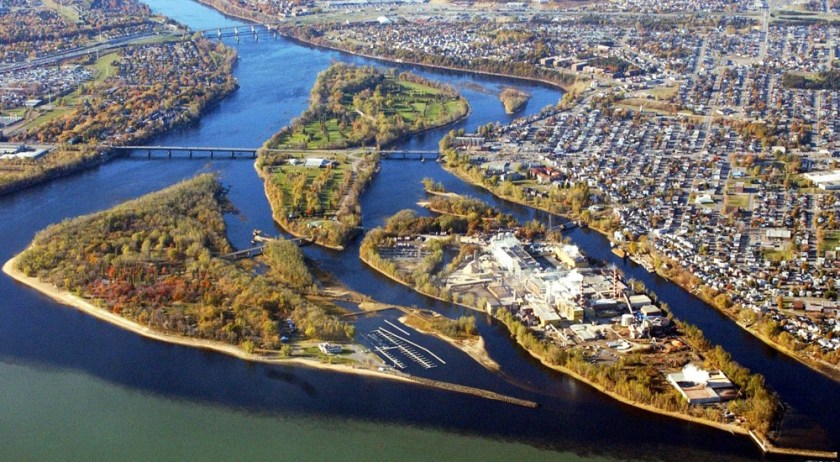
(Photo credit: cruisemapper.com)

The main downtown part of the city (where I ate dinner, anyway) is left of the river as seen in the photo above.  The two bridges in the upper left corner of the photo above carry Highway 40 just north of town and the racetrack is located on the opposite side of Highway 40 from town.

Now let’s talk about the race track.  Three Rivers, as far as auto racing is concerned, is what’s known as a street course.  Unlike a formal race track, like Indy or Charlotte, which are known as “closed courses” and are used exclusively for racing, a street course is a temporary track which is run largely on normal city streets which are, obviously, closed to the public for the duration of the event.  Temporary concrete barriers and chain-link fencing is installed at various points around the track to help confine the vehicles and protect the viewing public.  Once the event is completed those barriers are taken away and the streets are once again used by the public.

Here is a map showing the current configuration of the Three Rivers Circuit:

circuit et legende_2017_NASCAR_FRA V4

(Photo credit: gp3r.com)

I say “current configuration” because I have seen other maps showing a different, slightly longer race surface.  In the map above, the orange band represents where the cars race.  In the bottom portion of the photo you see a gray oval.  That is a permanent HORSE race track known as the Hippodrome (a Greek and/or Roman term for venue).

IMG_20190820_092722679_HDR

IMG_20190820_092929538_HDR

IMG_20190820_092940622_HDR

In researching this post I saw track configurations which included the car track encroaching on major parts of the Hippodrome, across the horse oval (which is NOT paved) as well as through the “infield,” and I am quite surprised to learn that ever was the case!

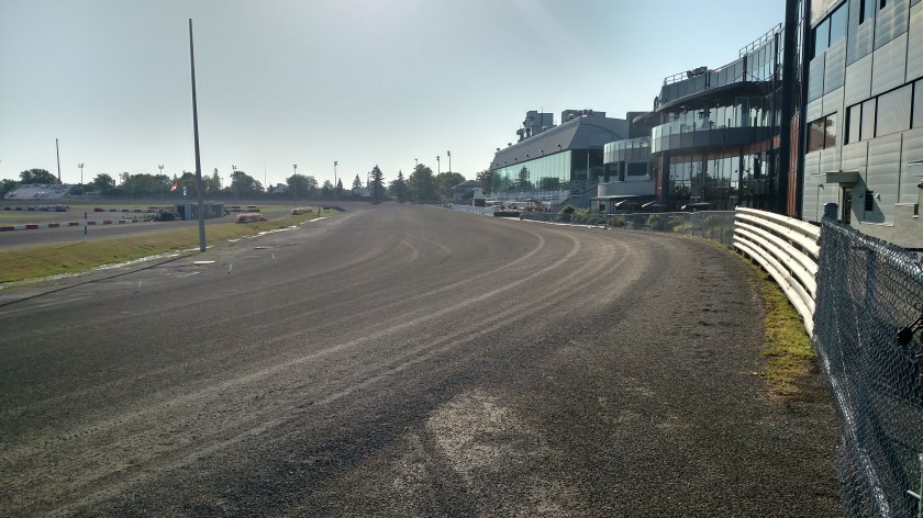
Well, I’m interested in CAR racing and given that the races were held several weeks before I was there I was now able to walk and drive on many of the areas where the cars raced.  These photos are in the order they were taken which, as it turns out, is almost the exact OPPOSITE of how the cars raced.  The cars travel counter-clockwise.  I parked in the Paddock to the left of the horse oval in the track configuration photo.

IMG_20190820_092323065

IMG_20190820_092338147

IMG_20190820_092349201

IMG_20190820_092414110

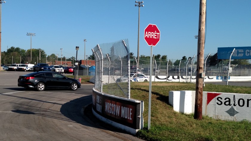
The Stop sign in the photo above is moot.  First, the cars would be going through this turn in the opposite direction.  Second, it is likely covered or removed during the event.  By the way, the white and blue car you can see below the Stop sign is a police car, not a race car.  The brick building on the right side of the second photo of this sequence is a local police substation.

IMG_20190820_092433784

IMG_20190820_093552110

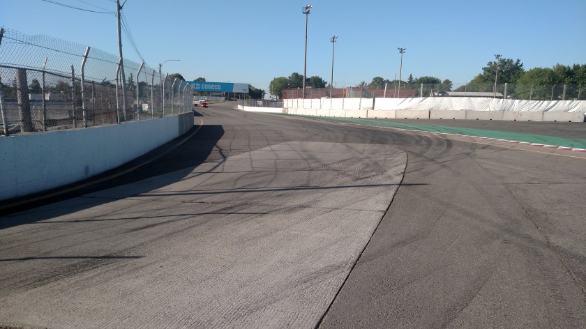
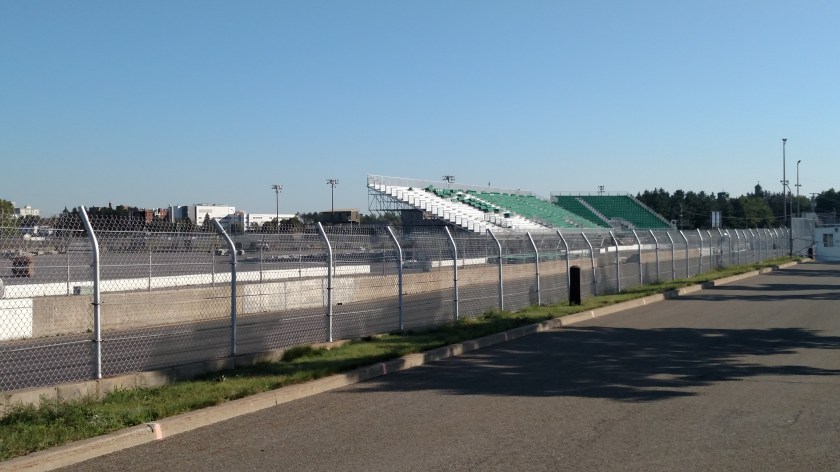
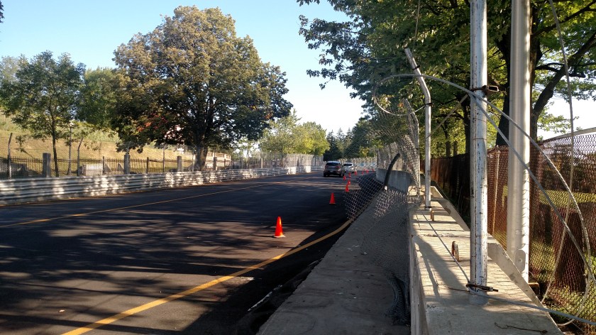
The photos above were taken near the end of a normal “lap,” on the left side of the track map.  The following photos were taken near the beginning of a lap, on the right side of the track map.

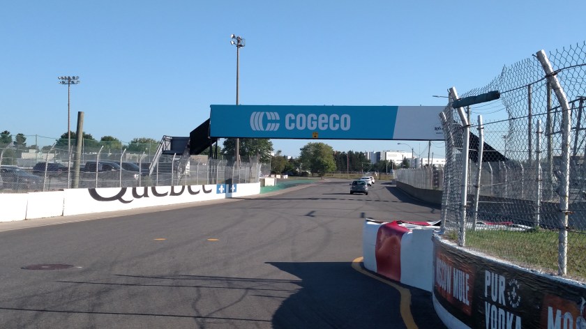
Unlike a “regular” race track, cars make two 90-degree turns shortly after getting the green flag, right then left, and descend a slight hill towards this stone gate, then make a hard left turn (Turn 3)…

IMG_20190820_094129424_HDR

… and continue away from the camera up this narrow city street and on to other parts of the course (Turns 4-11):

IMG_20190820_094306682

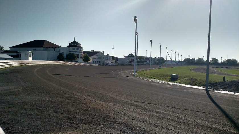
As they descended down the straightaway towards the 3rd turn they passed the racetrack “office” on top of the hill to the right as seen below:

IMG_20190820_094405143_HDR

IMG_20190820_094529321_HDR

DSCN0266

DSCN0269

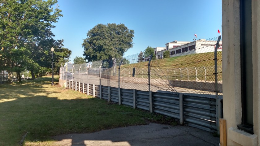
GP3R is the abbreviation for Grand Prix de Trois-Rivières, what the marquee event held at the track is called.

Québec City to Trois-Rivières

August 19, 2019

When I made the last post on September 12 announcing that I was taking another brief “vacation” I stated that I would resume posting in late September.  I suppose the afternoon of the last day of the month is as late as I can get….

IMG_20190930_152006691

Monday, August 19 was a travel day as I would say “au revoir” to Québec City and head southwest, ultimately to my next overnight stop in Trois Rivières.  Before leaving the city I thought about giving Parc Nationale de la Jacques-Cartier (the “National Park” that isn’t a National Park) another chance but the weather wasn’t conducive to sightseeing at elevation (foggy with a threat of rain) so I made a quick stop at the Vidéotron Centre which wasn’t far from where I had been staying for the past few nights (I could have easily walked there but was leaving town anyway so I took my car).

IMG_20190819_100611041

This entertainment facility was designed, and construction began, in 2012 and was completed three years later.  It is primarily designed for ice hockey and was built with the hope of attracting an NHL franchise, or perhaps enticing the League to add an expansion team.  So far that goal (pun intended) remains unfulfilled.   In the meantime it serves as the home of the Quebec Major Junior Ice Hockey “Remparts,” as well as hosting music and other events.

If you have ever attended an event at this facility and felt there was something unusual about it your suspicions are not without merit.  It was specifically designed with a very steep “bowl” of seats to make guests feel as if they were over the ice.  As a result of the ever-increasing seat pitch the “nosebleed” seats literally have a safety rail in front of every row of seats – to satisfy local safety regulations and I suppose to keep rowdy fans from toppling down onto the ice.  I would have thought arm restraints might have served that purpose as well but then they couldn’t enjoy their beer and would be even rowdier.

Next I drove down to the St. Lawrence River to head southwest.  There was a park quite a ways out of town from which I hoped to capture a photo of the Québec City skyline but the tower I climbed at that park wasn’t high enough to provide an adequate vantage point (even without the aforementioned poor visibility).  I continued southwest on a major highway before exiting in the little town of Sainte Anne de la Pérade.  First stop there was the Information Center:

DSCN0220

I am as puzzled as you are by the name on the building, though I can explain the fish.

While I was in the parking lot talking to some folks about to enjoy a picnic lunch I noticed a man examining (perhaps admiring) my license plate.  We discussed where I was from and what I was doing in Canada which inevitably led to a discussion of the blog.  He then informed me that this was the home of the world-famous “Tommy Cod” Fishing Tournament.  People from all over come to ice-fish for tomcod fish.  Silly me assumed that the name on the building had something to do with that but I just ran it through my “Reverso” app and found that Thématique means “subject” in French.  I wouldn’t have thought that Center Subject would have anything at all to do with ice fishing….

Before speaking with the various folks in the parking lot I had walked up towards the road to take a photo of the church I saw as I drove towards the Visitor Center:

DSCN0226

After getting the bulk of my conversations out of the way for the day I headed back out to the main highway, then drove north to Parc National de la Mauricie, which I had confirmed was, in fact, a Canadian National Park.  There were several good sized lakes at the Park and one long, winding river.

IMG_20190819_154712774


IMG_20190819_154950737

I saw this frog to the left of the dock as I walked down to the lake:

IMG_20190819_154854227_HDR

DSCN0233

And another, smaller one had jumped out into the water as I approached, presumably to avoid capture:

DSCN0229

Deeper in the Park I drove through a series of switchbacks in the road and when I finally stopped as an overlook was challenged by a sign there to determine if I knew which direction I was now looking (honest, officer, I’ve only had two drinks…).  The correct answer was southeast and I was released on my own recognizance.

IMG_20190819_165150408_HDR

DSCN0250

DSCN0244

As I exited the Park I stopped at another one of the lakes to take another photo, this time free from interrogation.

IMG_20190819_170822665_HDR


Last post until the end of September

September 12, 2019

Real time.

Here I go again….  Today I’m off to Knoxville, Tennessee to begin an impromptu, whirlwind trip to southwest Ohio, eastern PA, southwest New Jersey and western Virginia to visit family and friends.  I should be back in Durham just before the end of the month.  I will not be making any posts during this trip.

I still have pictures from the final 9 days of my trip to eastern Canada to post including my stops in Ottawa, Toronto and a boat trip through the “Thousand Islands”.

Here are one of the last things I saw in Québec City – some cool shelters located at a street corner near the restaurant where I had dinner the night before I left town.

IMG_20190818_184434296_HDR

IMG_20190818_184612860_HDR

Canadian Sign Language – Part 2

September 10, 2019

Real time.

Canadians love pictures on their road signs.  Here are more examples of signs I saw while visiting Canada earlier this year.  I either took these photos or saw similar signs during my journey.  Sometimes it wasn’t safe or practical to stop and get the actual photo.

This was the sign I mentioned having seen the day I drove through Chandler, QC on my way to Gaspé:

Landfill

I presume it means “This is where the Canadian mob buries the bodies”.  I didn’t go back to take a photo of the actual sign I saw but found this online in one of the provincial Driver’s License manuals (which is why it is so tiny).

Next up:

bed-and-breakfast

“Motel ahead.  You’ll sleep like an egg.”

I saw that one several places as part of a collection of signs at a highway exit indicating which services could be found after taking the exit.  And along the same vein:

Microbrasserie

“How about grabbing your driver another beer…”.

I also saw this sign several times during my trip, but usually in places where I couldn’t stop to take a photo:

NoRacing

“No drag racing”  (It actually means No Passing and was generally found in construction zones).

I saw this sign shortly after getting off the ferry as I drove northeast past Tadoussac, QC.

IMG_20190815_102119583

One place I DIDN’T see it was the previous day on the opposite side of the St. Lawrence River as a logging truck pulled out onto the highway well ahead of me and when I caught up to it was showered for several miles with bark, chips and wood dust and debris.  I bet that truck weighted 100 pound less when it arrived at it’s destination than it did when it started out earlier in the day.

I saw a sign like this a few hours later as I drove back south towards Tadoussac and was descending a hill after having passed a small ski area:

Runaway Truck Ramp in Canada
Guide and information road sign in Quebec, Canada – Runaway truck ramp.

The image-grab contains the description of what the sign above depicts.  For safe measure this sign also accompanied it:

CarInRunaway

“Don’t pretend you’re driving a truck”.

As I was literally driving on to the westbound ferry in Tadoussac I saw this sign off near the ferry-boarding ramp:

No Peeing
No peeing thin line icon, prohibition and forbidden, no toilet sign vector graphics, a linear pattern on a white background, eps 10.

Again, the image-grab explains the obvious meaning.  This wasn’t the actual sign I saw and believe me, I have scoured the internet trying to find the exact image.  The sign I saw looked like a drawing of a small cherub, like the “peeing child” sculpture in Belgium but with the classic red circle and slash indicating NO.  Since making that ferry crossing I have examined all future crossing sites or logical places for it’s use but with no luck.

Along the same lines…

GoPeeOverThere

This one means “Go pee over there”.  Full disclosure – the sign above is incomplete and would normally contain letters and numbers in the white space above the arrow indicating what days and times you are allowed to park in the area indicated by the direction of the arrow.

And while on the subject of ferries:

TruckMissedFerry

“This ferry is for cars only.  If you’re driving a truck, sorry pal, go find your own ferry”.  Actually every ferry I rode during my trip cheerfully accepted cars, trucks, motorcycles and pedestrians (as long as they weren’t peeing).

I saw this sign late in my trip, on a travel day as I was dreadfully close to putting myself “on the clock,” hence the reason I didn’t go back to get a photo of the actual sign:

NoFloor

“Surprise! This covered bridge has no floor.  Hope you’re wearing a life jacket”

And speaking of surprises, I saw this as I was approaching Québec City:


Fog in Canada
Warning road sign in Quebec, Canada – Fog.

Don’t believe what you read.  This means “The guy in the car ahead of you just farted”.

I saw this sign near a bus stop in Toronto:

IMG_20190826_174005215

“If there’s water on the roadway, speed up and try skipping over it like a stone”

And finally, I saw three of these signs the last morning I was in Canada.  I had seen the orange one while walking around in Toronto.

IMG_20190824_124925157

“You’re about to get hit by a large truck”

And out on a country road a few days later:

IMG_20190827_085316297_HDR

“Now you’re in real danger.  You’ve stumbled into a Canadian Demolition Derby and you’re about to get hit by trucks coming at you from all directions”

We’ve probably all seen “No Outlet” signs on dead-end streets or cul-de-sacs.  This one is more positive:

IMG_20190827_082847199

“For you savvy electric car owners – Electrical Outlet Ahead”

And one slightly more cryptic sign:

IMG_20190827_083641641

I’m thinking… “You’ve stumbled into a black-paint-balloon dodgeball course”.  I’m not sure but it is perhaps another “Fog Ahead” warning


And one humorous sign I saw (though not this particular one) in, always one to be a rebel, Québec province.  This one has no pictures and nothing but words but deserves honorable mention:

JakeBrake

Ever-proper, Québec can’t even bring itself to use the American slang term “Jake Brake” (when a large truck uses it’s engine to slow itself down by having the driver downshift, often resulting in an obnoxious sound which many small towns prohibit within their jurisdictions).  Evidently in Québec it’s a “Jacob” Brake, thank you very much.


Québec – Day 3 – Post 1 of 7

August 18, 2019

Sunday morning, after having walked around Québec City the two previous days, I decided to use my car to drive to two local venues I wanted to see.  First stop, Parc Nationale de la Jacques-Cartier, about a half hour north of the city.

If you’ve been keeping up with my sporadic posting you may recall that in my rage I posted about what happened there in real time when I got back to my Airbnb that afternoon (search for “How about if we call a spade a spade” on the Home Page or use the calendar grid there to go back to August 18, 2019).  Let’s just say things didn’t go well and JohnBoy went somewhat ballistic, then stewed about it for a few hours.

One thing I didn’t address in that post was my attempt to even get to the goofy Park using my new and relatively untested GPS 4.0.  I had looked up the address for the Park before leaving my Airbnb and given the way my new Garmin GPS accepts data I entered what I thought was the correct address.  She took me to a residential area about 10 miles away from the actual entrance.  After I made my last turn before she announced “You have arrived” I encountered this young girl standing in the middle of the road.

IMG_20190818_112824805

(That photo was taken while at a full stop, Shawn).

After I interpreted the sign she was holding I swerved left and ran her over.

JUST KIDDING!  It looks like she would have bounced right back up anyway.

I went back to a Tim Hortons I had passed after getting off the highway exit I had taken and got on their wifi to get a new address.  You can read in my previous post what transpired next.


After visiting venue 2 for the day (see the next 6 posts immediately following this one) I went back to my Airbnb to calm down.  One thing which helped keep my mind from revisiting the Park experience was getting online to research Canadian Highway Signs to use in future “Sign Language” posts.  I found one of the provincial Driver’s Manuals and combed through just under 2,300 pictures of various signs (152 pages with 15 on a page.  There were only about 7 on the last page, including the pooping dog I posted the day I entered Québec province.  They saved the best for last!).

Now that I’ve posted all my photos from Québec City I will put together another Canadian Sign Language post.  This one will only include signs I have actually seen.  Eventually I will post some of the ones I saw in the Driver’s Manual but didn’t ever see in real life.  I also have some from the US and other parts of the world I have either seen in person or found online.


Québec – Day 3 – Post 2 of 7

August 18, 2019

After my upsetting experience at the National Park which wasn’t a National Park I shifted my attention to the second venue on my agenda for the day.  These are the amazing Montmorency Falls just east of Québec City.  I had actually driven right past this on my way in to town a few days earlier but it was tucked back in behind a mountain so I had no idea it was here.

IMG_20190818_133826561

This place is incredible and totally got my mind off the events of the morning!

There are several things to talk about here and I’ll address each one in a separate post.  First, the falls themselves.  There are three different waterfalls in the photo above, the most obvious carrying the bulk of the water flowing down the Montmorency River.  The main fall is 272 feet high, 99 feet taller than Niagara Falls.

To the left is a smaller fall and to the left of it an even smaller one.

Here is a photo of all three (without the stairway to the right)

DSCN0132

And each one individually:

DSCN0106

DSCN0107

DSCN0162

And while I was going through the various shots I took to decide which ones to post I discovered that I inadvertently captured a seagull in flight in one of my closeups:

DSCN0189

Better to be lucky than good…


Québec – Day 3 – Post 3 of 7

August 18, 2019

One way to get to the top of Montmorency Falls, just east of Québec City, is to ride a ski-lift-like tram:

DSCN0113

DSCN0115

DSCN0120

Once at the top you may walk over the Montmorency River on a bridge:

DSCN0143

And you may also walk across another bridge way off to the right of the falls to where they launch the people who paid to zipline back across the falls.

DSCN0158

I didn’t go up there so I don’t know if the top of the stairs connects back to the zipline launch area or not (in which case you could ride the tram up and walk down the stairs).

The cost for the tram:  $ 14.25 CAD one-way or $ 16.75 round-trip.  You must also pay for access to the park (I paid $ 12.50 CAD to park and walk in).  Multiply CAD by roughly .75 to get US dollars.

And before you commit to riding the tram, here was the line (granted it was Sunday afternoon at around 12:45pm local time):

IMG_20190818_134423134_HDR

IMG_20190818_134419604

IMG_20190818_134416718_HDR

IMG_20190818_134413425_HDR

Québec – Day 3 – Post 4 of 7

August 18, 2019

One of the ways to get a closer look at the falls is to walk out around the water from the Visitor Center to an observation area near the base and/or climb an incredibly tall set of stairs on the right side which leads up to near where the zipline launches.  I did not do either one.

DSCN0139

DSCN0135

DSCN0137

DSCN0138

DSCN0142

Québec – Day 3 – Post 5 of 7

August 18, 2019

Shortly after I arrived at the Visitor Center for Montmorency Falls, just east of the city, I started taking pictures of the falls.  It wasn’t long before I started seeing people ziplining across the top!

DSCN0093

DSCN0094

To engage in this fun activity you need to park at the top of the facility and walk across the bridge over the falls to the zipline launch area.  There you, or you and a friend (there are two parallel lines), can fly suspended on a zipline 1,000 feet from one side of the falls to the other, an experience which lasts about 25 seconds.  The cost is a mere $ 31 CAD (plus admission to the facility).  There are videos on YouTube.

DSCN0124

DSCN0125

DSCN0159

DSCN0160

No, I absolutely did not.