Tuesday – Morning along the coast

Tuesday I drove from where I had been staying in San Rafael, CA north to Ukiah, CA.  Much of the drive was along US Route 1 which, in many places, runs right along the coast.  Once I reached Route 1 in Point Reyes it was roughly 100 miles north to Manchester, where I had to turn and head inland towards Ukiah.  Here are some of the things I saw throughout the day:

IMG_20180710_111212334

IMG_20180710_111616906

IMG_20180710_112159323

IMG_20180710_112522343

IMG_20180710_112626764

IMG_20180710_113457864

IMG_20180710_113521320_HDR

IMG_20180710_113601646_HDR

IMG_20180710_114203589_HDR

And if wildfires and earthquakes aren’t enough to keep you on your toes, there’s always this.  If fire doesn’t get you, water might.

IMG_20180710_111205514

This was the view from the deck (and practically from my table) at the restaurant I went to for lunch.  The Jenner Inn, which came highly recommended, has new ownership and is now only open for dinner.  I went across the road to the Jenner Post Office and the woman working there recommended another place up the road.  It was an excellent choice.

This is a three shot panorama from right to left.  This is actually the Russian River draining into the Pacific.

IMG_20180710_120401820

IMG_20180710_120358755

IMG_20180710_120352482


Tuesday – Early Afternoon

Tuesday I drove from where I had been staying in San Rafael, CA north to Ukiah, CA. Much of the drive was along US Route 1 which, in many places, runs right along the coast. Once I reached Route 1 in Point Reyes it was roughly 100 miles north to Manchester, where I had to turn and head inland towards Ukiah. Here are some of the things I saw throughout the day:

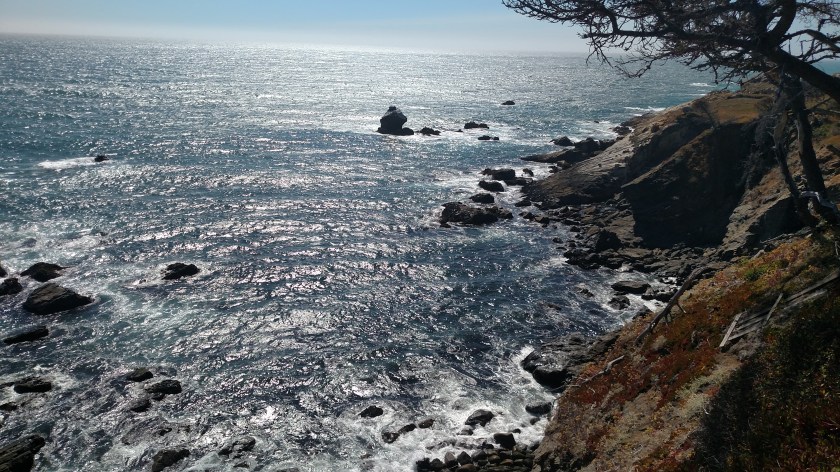
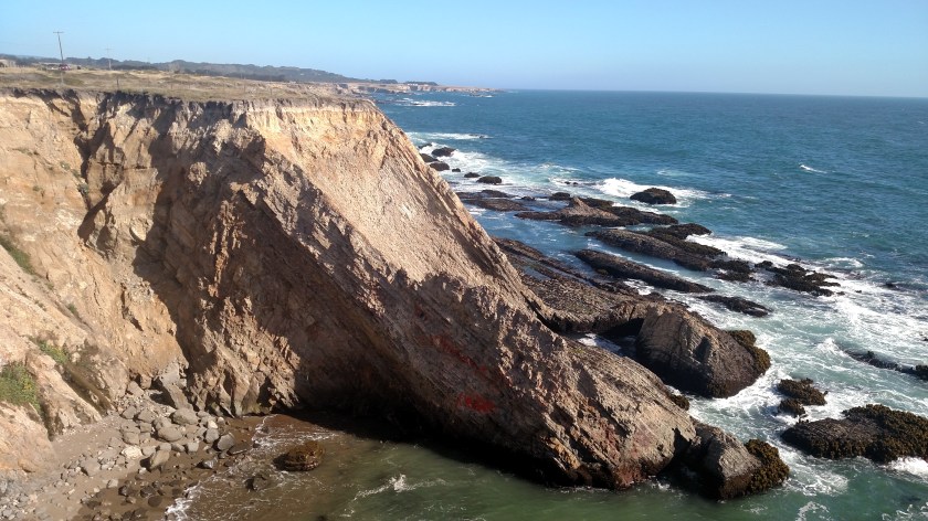
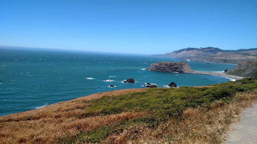
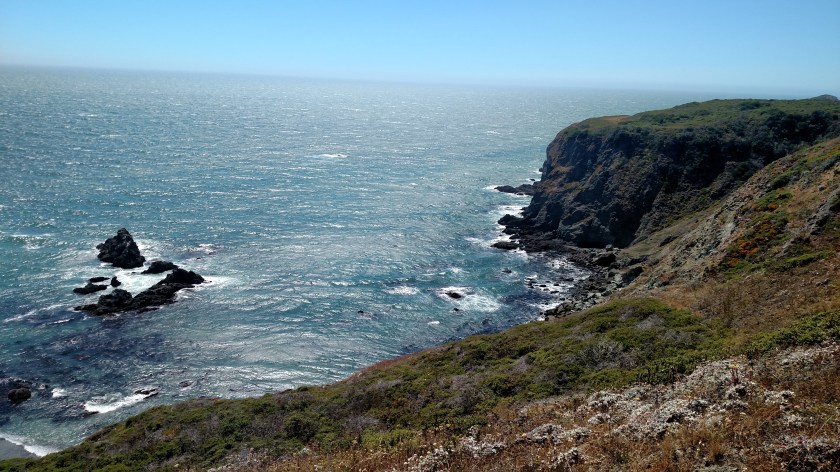
After having lunch in Jenner I continued up the coast towards Manchester. I actually backtracked a little ways to some of the more interesting things I had seen to take a break and just watch the birds fly and sit and listen to the ocean. It was INCREDIBLY windy – a very stiff, steady wind (in North Carolina we often give them names…). Believe me, at times it was hard to just stand and hold the camera out in front of me. I once had a client in North Carolina who came to our office when it was extremely windy in Durham and commented “I don’t know how little people stay on the ground”. I was worried that the constant movement might make my pictures blurry but fortunately they turned out ok. Even with full sun the temperature was only 60 degrees which made the wind chill about 10 below. It really didn’t feel all that cold, even though I was only wearing shortpants and a t-shirt.

IMG_20180710_125856168

IMG_20180710_125901666

IMG_20180710_125952778

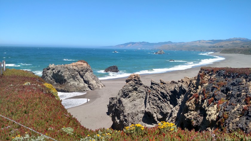
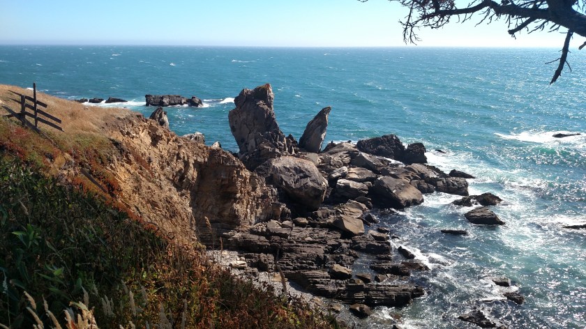
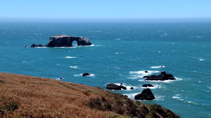
Below is the same rock formation seen at the top of the first photo of this post. When I drove up the road a short ways from where I had been parked I noticed it had a big hole through it. Some of the formations in the next post (Late Afternoon) also have such holes, creating an arch above them.

IMG_20180710_130207270

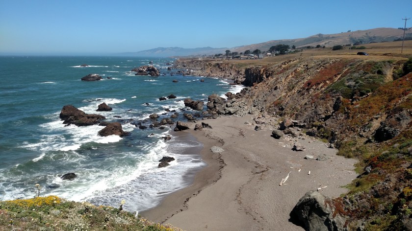
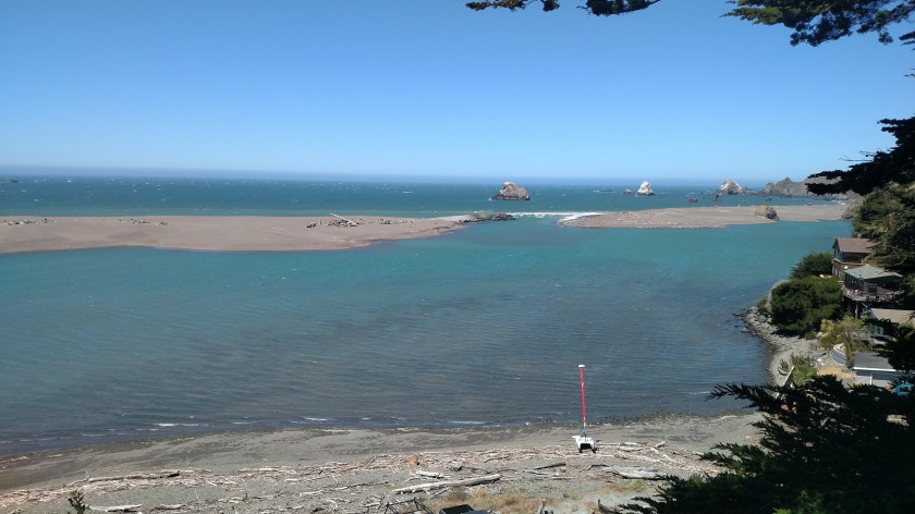
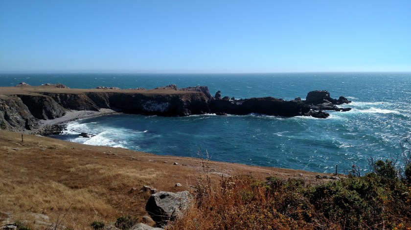
This is a beach called Goat Rock. If you look closely you’ll see vehicles parked along the beach access area.

IMG_20180710_130215795

As I was driving back out to the main road I noticed this phenomenon to the south. If you look very closely a little right of center you’ll see a “cloud” rising up from the ocean surface and going towards land. I tracked down a lifeguard who I had seen driving from beach to beach and asked him what it was. It is fog forming. I could see a layer of fog out at sea (which oddly looked white while wearing my sunglasses but gray when I took them off) and while I could clearly see this white cloud of fog forming near the coast with my sunglasses on it was more difficult to see without them (and in the photo).

IMG_20180710_130528040

IMG_20180710_132941937

IMG_20180710_133321523

IMG_20180710_151350663

IMG_20180710_151410132

IMG_20180710_151652005

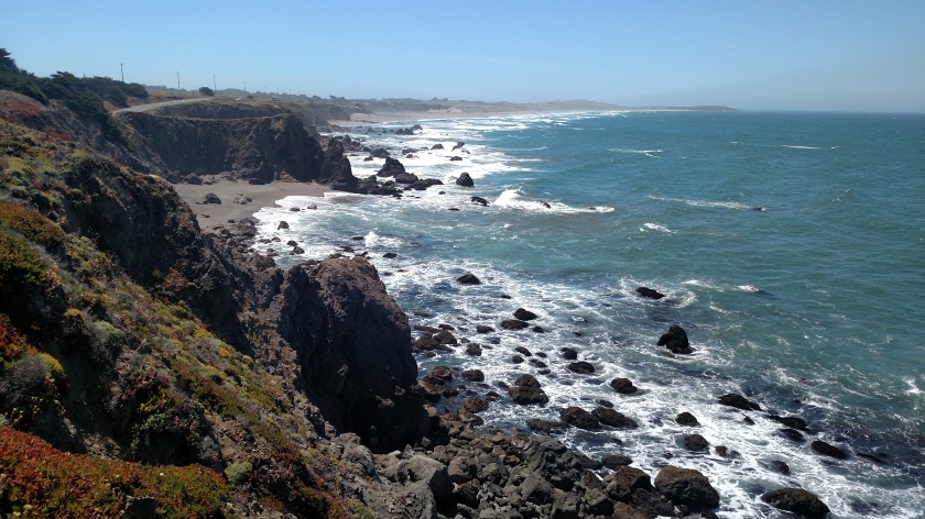
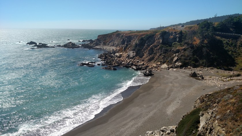
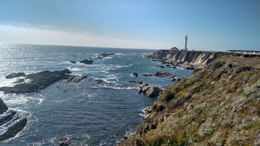
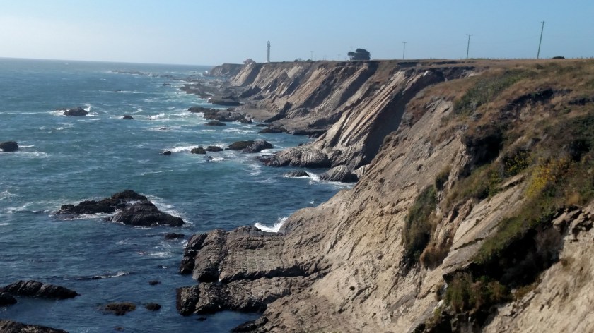
Looking north up Highway 1 I could see that this was where the road was going to take me next.

IMG_20180710_151711529

IMG_20180710_151909135

IMG_20180710_151923103_HDR

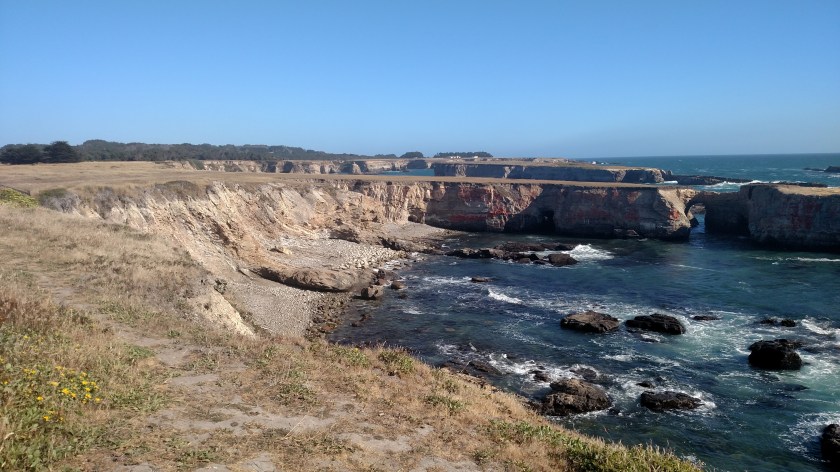
And this was the the view looking back down at where I had just come from.

IMG_20180710_152332334

IMG_20180710_153304078

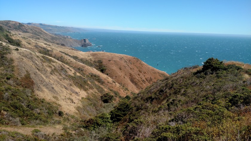
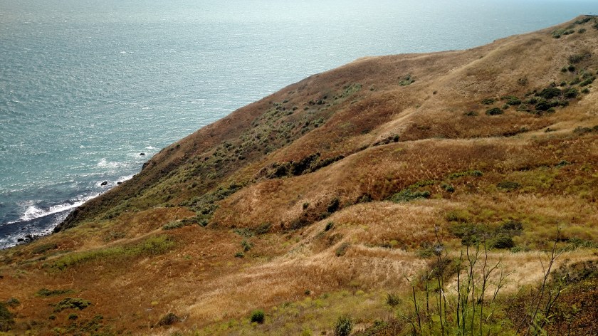
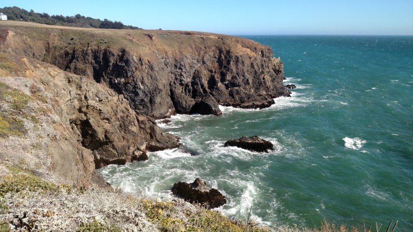
Looking north this was the hill above the road:

IMG_20180710_153324277

And as the hill descends to the ocean:

IMG_20180710_153327327

IMG_20180710_153346646

Tuesday – Late Afternoon

Tuesday I drove from where I had been staying in San Rafael, CA north to Ukiah, CA.  Much of the drive was along US Route 1 which, in many places, runs right along the coast.  Once I reached Route 1 in Point Reyes it was roughly 100 miles north to Manchester, where I had to turn and head inland towards Ukiah.  Here are some of the things I saw throughout the day:

IMG_20180710_155319198

IMG_20180710_155326373

IMG_20180710_162506673

IMG_20180710_162832345

IMG_20180710_162906234

IMG_20180710_163319165

IMG_20180710_163341043

IMG_20180710_171036862

IMG_20180710_171231125

This is the Point Arena lighthouse.  It closed about an hour before I got there but I am hoping to get back there on Thursday to get a closer look.

IMG_20180710_172842155

IMG_20180710_172859007

IMG_20180710_172901943

IMG_20180710_172946149_HDR

IMG_20180710_172958427_HDR

IMG_20180710_173035994

IMG_20180710_173608769

IMG_20180710_173414559

IMG_20180710_173625728

Ferry ride to San Francisco

Monday was my last full day in the San Francisco area and I rode one of the Golden Gate ferries over to the city.  The ferry station parking lot was full but fortunately I could find free street parking nearby (the same place I had parked the other day when I took a photo of the “Mendocino” arriving) and just barely caught the 940am ferry.  Once in the city I walked to the Museum of Modern Art and spent about two hours walking the 7 floors of exhibits.  My Fitbit informed me I had my 10,000 steps in for the day as I was walking back to the ferry station.  Here are a few photos from the morning ride over to the city:

IMG_20180709_094300291

IMG_20180709_094609804

IMG_20180709_095138422

I leave San Rafael later this morning to resume my drive north up the California coast.  I’ll be spending the next three nights in Ukiah, California (inland a bit) and hope to finish posting many of the pictures I took in this area while I’m up there.  I plan to just take my time and meander up the coast, eventually all the way to the Canadian border.

Sausalito, California

Thursday I ventured in to Sausalito for the first time.  Sausalito is located along the shore of Richardson Bay, north of the Golden Gate Bridge.  There are many neat (and expensive) restaurants in town, as well as some beautiful homes.  There is also a huge marina housing a wide variety of boats.

IMG_20180705_135458538

IMG_20180705_140407263_HDR

IMG_20180705_151013570

Crowds gathered along the marina to watch this guy work.  It was fascinating to watch him raise and lower the big poles (extreme right of photo, and another at the far end of the platform) to anchor his platform and use the arm of the huge backhoe-type machine to position his rig.  He was apparently scraping the bottom of the Bay to provide additional clearance for large boats to dock.  His trusty dog had a wonderful time scurrying along his platform chasing seagulls and watching him raise and lower the mechanical arm and dump water and mud.

IMG_20180705_135518495

Now this is what I call a true houseboat!

IMG_20180705_135811895_HDR

IMG_20180705_135902638

And here is another one:

IMG_20180705_140008503_HDR

I hope these mobile homes don’t get too mobile…..

IMG_20180705_140341053_HDR

A good reason to come to Sausalito in December:

IMG_20180705_145807136_HDR

IMG_20180705_154830647

When I left Sausalito to drive to my next destination I discovered that it actually wraps around the southeast corner of the peninsula giving a great view of downtown San Francisco and Alcatraz Island.  I didn’t have time to take more pictures from this vantage point but returned on Sunday to get more photos which I will post later.

IMG_20180705_160639957

DSCN2813

DSCN2817

Here is the city skyline.  You can see the iconic TransAmerica Pyramid and to it’s right the new Salesforce tower, which will soon be the tallest building west of the Mississippi.  At the far left is Coit Tower on Telegraph Hill.

DSCN2822

I was hoping to make it out to Alcatraz for a tour but didn’t make a reservation (and tours are booked through the end of July) so it will have to wait for my next trip to the area.

DSCN2829

The Bay Model

One of the more interesting things to see in Sausalito is the Bay Model, constructed by the US Army Corps of Engineers in the mid-1950’s.  This 1.5 acre hydraulic scale model of the San Francisco Bay and Sacramento-San Joaquin River Delta was designed to help scientists and engineers study the effect of various weather and man-made scenarios on the local environment.  Little metal strips are scattered throughout the model to help accurately simulate tides and the flow of water.  With the advent of computer-assisted technology this model is no longer used.

Here is a small (dry) sample of what the Model looks like up close:

IMG_20180705_154051699_HDR

And here are some photos of the actual Model.  It is housed indoors in a large building which covers more than two acres:

IMG_20180705_153813829

IMG_20180705_153836302_HDR

There are little signs indicating where cities, bridges and various landmarks are:

IMG_20180705_153849064_HDR

If you look closely there are two people standing just to the right of center in the following photo:

IMG_20180705_154138104

There are also large signs hanging overhead which name the general regions of the area:

IMG_20180705_154204253

I went over this bridge (the real one) Thursday morning when I drove from San Rafael over to Berkeley:

IMG_20180705_154328386

Golden Gate Bridge

There are numerous spots on both sides of the bridge where there are overlooks affording the viewer some great photo opportunities.  Thursday afternoon I went to several on the northwest side.

IMG_20180705_163905639

IMG_20180705_164114320

IMG_20180705_165957322

Friday morning I crossed the bridge to get over to the southwest side.  While Thursday was sunny and warm, Friday morning was very different – overcast and chilly with a stiff wind – much more San Francisco-like.  Mark Twain is once thought to have observed “The coldest winter I ever spent was a summer in San Francisco” (although historians are beginning to suspect that he never actually said it.  It is a great line, regardless of who thought it up).

IMG_20180706_110022410

DSCN2930

DSCN2943

Marin County Civic Center – Post 1 of 2

Thursday I visited the Marin County Civic Center which was designed by renowned architect Frank Lloyd Wright.

This complex is so big it is next to impossible to find a vantage point to get it all in one photo.  Here is a scale model of the main building (there are also buildings on the property at the fairgrounds, where the Marin County Fair just concluded with July 4th fireworks, and a nearby outdoor amphitheatre).

IMG_20180705_100246864

IMG_20180705_100342559

IMG_20180705_094847672_HDR

IMG_20180705_094852487_HDR

IMG_20180705_095050816_HDR

IMG_20180705_095427695

The original design called for the roof to be gold (to blend in with the local mountains and to conform with California’s motto as “The Golden State”) and the spire to be blue.  Those color choices were ultimately swapped, which I think turned out very well.

IMG_20180705_100554464

IMG_20180705_100615975

Marin County Civic Center – Post 2 of 2

Thursday I visited the Marin County Civic Center which was designed by renowned architect Frank Lloyd Wright.  Here are additional photos:

Inside the building the long corridors include atriums with plants and skylights:

IMG_20180705_101255906_HDR

Workers were in the process of renovating the blue domed roof:

IMG_20180705_102007136

This is a fountain located outside the second floor cafeteria:

IMG_20180705_102020986_HDR

IMG_20180705_102056114_HDR

And a view looking out from the balcony:

IMG_20180705_102144570_HDR

IMG_20180705_102204208_HDR

More roof work:

IMG_20180705_102245640

Mr. Wright also designed the Post Office located across the street from the Civic Center:

IMG_20180705_105131643

IMG_20180705_105205457

Eddie’s House

As some of you know from previous posts I am a fan of structures designed by renowned architect Frank Lloyd Wright and try to visit houses and buildings he designed during my travels.  Well, this may come as a surprise even to FLW fans but he once designed a doghouse!  I heard about this on NPR a few months ago and learned that it was designed for a family who lived in this area.

Mr. Wright designed a home for the Robert Berger family of nearby San Anselmo.  When the house was completed Mr. Berger relayed his 12-year-old son’s request that Wright design a doghouse which would fit in with the house design but would be inexpensive enough so his son could pay for it with money earned on his paper route.  Mr. Wright wrote back that he was too busy and that they should ask again a year later.  Well they did and this time Mr. Wright complied.

The design was completed in 1957 but construction wasn’t completed until 1963 (after selling many newspapers!).

Here is a photo of the original doghouse:

Eddies House

(Photo credit: wikipedia.org)

The doghouse was thrown out after it was no longer needed but was later reconstructed following the original plans (note that it is sitting up on a dolly so appears taller than it actually is):

Eddies House 2

(Photo credit: sf.curbed.com – courtesy of Marin County Civic Center)

J Michael Welton

(Photo credit: J. Michael Welton)