Gander, Newfoundland

July 29, 2019

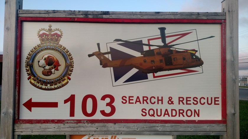
I spent Monday night in the town of Gander, located in northeastern Newfoundland.  When I arrived in town this was on top of the Welcome sign:

IMG_20190729_171845407

For those of you who don’t know me, I am a helicopter enthusiast.  I have been fascinated by them since I was a kid and for several years, before getting the Airbnb bug, I was learning to fly radio-controlled helicopters.

Exactly two minutes after I took that photo a large, yellow helicopter flew over:

IMG_20190729_172045275

Literally, the time stamp on the first photo is 17:18:45 and second is, you guessed it, 17:20:45.

When I got to my Airbnb I asked my hostess, who lives about a mile from where I took those photos, if there is a reason for the helicopters.  Sure enough, there is a Canadian Search and Rescue squad based next to the Gander International Airport.

IMG_20190730_053705613

IMG_20190730_053842719

This was the helicopter I saw flying.  I took this photo the next morning as I was leaving town to head south to my next stop.

DSCN8207

Twillingate to Gander, NL

July 29, 2019

These are some photos taken at a look off near where Route 340 ends in Twillingate.  There was a high rock peninsula I could walk up on to look out over the water.  The first two are looking down into a cove near where I parked my car.

IMG_20190729_131356396

IMG_20190729_131639573

I had an incredible view over a large expanse of water.  I won’t post those photos (just water, folks, and boo-hoo – no icebergs…) but it was neat to just stand there for a while, ponder the meaning of life and enjoy the journey I’m on.  And in case those of you familiar with this area are wondering, I am NOGO FOGO.  Fogo Island and Change Island are located just off the coast east of here.  Time does not permit me to take the ferry out there this trip but I have already decided I am coming back up here next year (woo-hoo!) to see some of the things I didn’t get to this time around.  The next photo is just a random shot before I left Twillingate and has nothing to do with the islands I just mentioned.

IMG_20190729_131809108

I turned around and started driving back south towards the TCH:

IMG_20190729_134120540

IMG_20190729_135048437

IMG_20190729_151947164

I followed the map in my book to see several small villages off the main road.  This is often where I take many of the photos you see.

IMG_20190729_152123161

I took some other “regular map indicated” scenic roads over towards Musgrave Harbour.  In the little town of Frederickton I saw a sign for Shipwreck Point and of course I had to drive out to the end of it:

IMG_20190729_152538351

The photo above shows what’s left of the SS Ahern Trader which ran aground here in 1960.

This was off Route 330 near the communities of Aspen Cove and Ladle Cove.  The scene below wasn’t staged.  This was exactly how I found it.

IMG_20190729_160451103_HDR

These three buildings were just up the road.  Remember the middle one because you’ll be seeing that theme again in a few days…

IMG_20190729_160615666

IMG_20190729_160651187

IMG_20190729_160720083

Deer Lake to Twillingate, NL

July 29, 2019

Before I post photos from this leg of my journey I have 3 more pictures from up near Quirpon which I want to share.  This shot is in that village itself.  At the extreme northern end of the Northern Peninsula of Newfoundland I noticed that many of the bodies of water, both large and small, had huge rocks (too big for a single person to move) in the shallow water close to the shore.

IMG_20190728_071802407_HDR

These two shots are from just down the road in little Saint Lunaire-Griquet:

IMG_20190728_072907156_HDR

IMG_20190728_073132141

OK – now that I was back in Deer Lake (Monday morning) I headed east on the Trans Canada Highway towards my next overnight stop in Gander.

IMG_20190728_202015671

As I drove east I saw several good photo ops.

Someone thought this sign needed a visual aid:

DSCN8192

DSCN8195

The State of North Carolina would run out of these signs…

IMG_20190729_084720142

IMG_20190729_083654491_HDR

IMG_20190729_084155667_HDR

IMG_20190729_093348452

When I got to Route 340 I turned north and took one of my primary scenic routes (from my book – they are always highlighted on orange on my maps) up to Twillingate.

This was a Railroad Park in Lewisporte:

IMG_20190729_111018874

IMG_20190729_111049641_HDR

This was further north up the road:

IMG_20190729_112005506

This is the Interpretive Centre near Boyd’s Cove.  As I drove out the very bumpy road to get to it I couldn’t understand why it wasn’t IN the town of Boyd’s Cove until I got there and found that it is mainly about the indigenous Beothuk people and is out in the boonies next to a reconstructed village (which I didn’t pay to go in to see).

IMG_20190729_115832897

Back out on Route 340 here are more things I saw as I drove north towards Twillingate, at the end of the highway.

IMG_20190729_122322451

IMG_20190729_124218560

The shot below was taken just before I got to town.  You are now looking out northeast towards the Atlantic Ocean beyond the two rock peninsulas.

IMG_20190729_130652572