Percé, Québec province

August 12, 2019

As the previous posts describes, I saw a large island close to shore as I approached the town of Percé which I thought was the popular tourist attraction people there which had been telling me about.  I thought to myself “Ho hum, it’s just an island, people…”.

Well THIS is Percé Rock:

DSCN9250

Percé in French means perforated or pierced, as in “there’s a hole in the rock because it’s been pierced”.

I backed off on the zoom so you can see how far out in the water it is:

DSCN9251

DSCN9253


DSCN9255

Jutting out from the shore is a peninsula with a large house and a smaller piece of land with another house, and I’m guessing maybe a cemetery up on the hill.

DSCN9259

DSCN9263

DSCN9267

Tourist brochures include a photo taken from the left of this view looking out towards the rock with the houses in the foreground but I couldn’t get to the spot where it was taken.  You may be able to find it online.  It is a great shot!

After getting these pictures I drove through the town of Percé which is a large area of trendy restaurants and shops.  It was around 5 o’clock and given the number of people milling about I was sure I would have needed a reservation so I just drove on, planning to eat once I got to Gaspé.

You probably can’t tell from the map I posted previously but there is a large cove north of town and as I drove back out towards the Gulf of St. Lawrence on the other side of that cove I could see the back of the formation off in the distance:

DSCN9306

DSCN9312

And the further I drove the better I could see it in profile against the setting sun:

DSCN9369

DSCN9365

After trying to get some bird pictures which I’m not real happy with I turned my attention back to things on land.

DSCN9387

I continued on to Gaspé where I would be spending the next two nights.


Bonaventure to Percé , QC

August 12, 2019

IMG_20190817_174143904

I continued east from Saint-Siméon and stopped in Bonaventure for lunch.  In the restaurant (actually just a small ice cream shop with some basic food) I took these two photos while waiting for the young lady working there to prepare my meal.

DSCN9185

Not other customers, they were small wooden gnomes up on a shelf.

This was a dessert the young lady could have made for me.  Cute (hence the photo) but I passed.

DSCN9186

I took my food outside to eat as it was a beautiful day.  After I finished I took these photos of a huge church right next to the little strip mall where I ate.  This is the Catholic Church of Saint-Bonaventure.  Lots of photos because it is another huge church and I didn’t want to miss anything, including the detail.

IMG_20190812_142559067

IMG_20190812_142633740

IMG_20190812_142719104

DSCN9176

DSCN9180

DSCN9178

DSCN9181

Further up the road was a little rest area and there were big batches of wildflowers:

DSCN9187

DSCN9193

I tried to get cute with some pictures of a sailboat way out in the water and using the flowers in the foreground but I’m not happy with how they turned out.

I continued, northeast now, on Route 132 towards the town of Percé (pronounced PEAR-see, and you must “roll” the r which I still can’t do).  My Airbnb host in Gaspé works in Percé and highly recommend I plan to spend some time there as I passed through the area.  Other hosts told me to be sure to see the Percé Rock.

When I got close to Percé I saw a large island not far offshore and thought to myself, “Percé Rock, eh?  Looks like just a big island to me….”.  The island is the one on the right in the first photo below and extends ever further right, out of the shot.

DSCN9223

DSCN9224

As I was taking these photos I heard a helicopter spooling up (increasing speed to the rotor blades) and sure enough, a tourist helicopter was taking off just up the road from where I was standing:

DSCN9231

DSCN9234

After watching it take off and leave (I LOVE helicopters) I went back to my picture taking.

DSCN9239

When I decided I had enough photos (you’re only seeing the best ones) I got in the car and continued driving.  As I climbed the hill and went around a bend I saw a large group of cars in a parking area and several people walking around.  In a moment I realized why.


Campbellton, NB to Saint-Siméon , QC

August 12, 2019

After crossing the bridge from Campbellton, NB to Québec province on Monday I started driving east along Route 132.  People had told me this would be a spectacular drive and I was not disappointed.  This is what makes traversing my scenic roads attractive and rewarding.  In this case, driving by water, be it a lake, river or ocean on a sunny day with the sun at your back is just magnificent.

IMG_20190817_174217687

Here are some of the things I saw along the way:

This is the Church of Saint Jean l’Évangéliste near Nouvelle, QC.

DSCN9160

Given that it was in the shade, here is a better photo I found online:

photo_nouvelle origins dot ca

(Photo credit: originis.ca)

Further down the road I saw this church high up on a hill very close to the road.  As I looked up towards it as I drove past the sun reflected off the silver steeple.  I took a photo from the base to try and show what I saw, then crossed the road to get the other photos.  This is Saint-Omer Catholic Church in Saint-Omer, QC.

IMG_20190812_125010767

DSCN9164

DSCN9166


DSCN9172

DSCN9169

I continued east on Route 132 and found this church in Saint-Siméon.  It is the Catholic Church of Saint-Siméon de Bonaventure.

IMG_20190812_140811495

Across the road and facing the Bay of Chaleurs (separating the Gaspé Peninsula from New Brunswick) were some little public balconies along a wooden boardwalk.  They had flowerboxes and I thought it would make a great picture looking out over the water.

IMG_20190812_141024278

I tried to move the blue & black recycling/trash bin out of the shot but it was literally nailed down (it gets quite windy out by the water) so I had to squat down and improvise:

IMG_20190812_141314154

From Pokémon to Pokeshaw Rock

August 11, 2019

Funny how things work out…  As I was preparing photos for the first post about things I saw in Québec province I found another group of photos from the town of Pokeshaw, NB, just west of Grand-Anse where I found the huge church with the bright red roof as I was driving towards the bridge to Québec province.

This is a huge rock out in the Gulf of St. Lawrence which is popular with bird lovers for obvious reasons.  There was an observation area which wanted a day use fee but I could park up by the road and, with my zoom lens, look for free.  I like free.

DSCN9126

DSCN9127

DSCN9131

DSCN9134

DSCN9149

Those photos were taken while looking northwest.  As I was walking back to the car I noticed this photo op looking northeast:

DSCN9151

I then continued on my way to Campbellton.  This was the view as the highway descended in to town.  This is part of my “go play in the road” collection, taken while I was standing on the yellow line (Shawn).

DSCN9158


And you think JohnBoy’s crazy???

August 17, 2019

Off topic, I know, but this is a hoot.

When I travel I generally monitor a Raleigh TV station’s website every night just to keep tabs on what’s going on back where I live (Durham is only about a half hour from Raleigh and although we have our own TV station, thank you very much, I prefer this one in Raleigh).

I found this article, which I post unedited, and accompanying photo on WRAL.com.  They do not credit the news service (Associated Press, CNN, etc) they got it from so I can’t either:

BURIEN, Wash. — A Washington state trooper who pulled over to help what he thought was a disabled vehicle found something else instead: The driver had eight phones simultaneously playing the video game Pokémon Go.

The driver was stopped on the shoulder of Highway 518 in Burien, south of Seattle, on Tuesday evening.

The agency tweeted a photo showing a blue foam square, with the phones sitting in eight rectangular cutouts.

Trooper Rick Johnson is a spokesman for the patrol and said Sgt. Kyle Smith did not issue a ticket because he did not observe the car moving while the driver was using the phones.

But Smith asked the driver to put the phones in the back seat and move along, because stopping on the shoulder is for emergencies only.

PokemonGo

And I worry about stopping on a busy highway in my SafetySam vest just to take a “hit run” shot of a great photo op!


And since I’m going off topic, I have a time-sensitive RFI (or RFS, as it were…)

I bought two candy bars the other day, one because it was recommended in my pre-trip research and the second because it sounded good (and was).

IMG_20190815_151543702

I took that photo with the candy bars on a towel placed on the hood of my car while in line waiting for a ferry.  The people in the car waiting behind me, undoubtedly QP people but I didn’t check, probably thought I was some kind of nutjob.  Hey, “sometimes you feel like a nut, sometimes you don’t”, which ironically applies somewhat to the Bounty bar.

Mirage, made by Nestlé, promises “Real Bubbly Milk Chocolate” (and special characters or not, I can’t make the letters in Bubbly dance like they do on the label.  If you look closely below the ‘M’ you may be able to see it…)

It wasn’t terrible but I don’t like to pay extra for air bubbles in my food unless it’s a beignet.

The Bounty bar, on the other hand (or in the other hand as I ate them at the same time – That’s a LIE Mr. Trump!!!) was made by a company not known to me but was like an Almond Joy without the almonds.  Not a Mounds, mind you, which is dark chocolate and one of JohnBoy’s favorites, but coconut covered with milk chocolate.  It was yummy.

I don’t always eat candy, but when I do….   to paraphrase the MIMITW who, regrettably,  isn’t used in ads any more.

Anyway – the people in the car behind me can think anything they like (zee crazy American, and look at zee crazy license plate…) as I was doing important blog stuff.

So my request (I almost forgot!) – any other suggestions for candy or other things I should try while I’m in Canada?  I’ve already had lobster rolls and poutine.  Don’t think about it too long….I’m only here for another 10 days.  If you have any, please post them as a Comment (left side of your screen at the beginning of each post) or share them with me privately via the “Contact” link on the Homepage.

Merci beaucoup!


Fun Facts about Québec Province

August 17, 2019

I am posting this Saturday morning, though I crossed in to Québec province 5 days ago.  For the sake of simplicity I will henceforth (in this post) refer to it as QP.  And if you think I already forgot, I seem to be unable to add the accent in the Title of this post, even using my newfound WordPress special character tool.  UPDATE – Got it working with “cut & paste” from post text!

QP is enormous (shaded in blue on the map below):

QuebecProvince quebecweb

(Photo credit: quebecweb.com)

At close to 524,000 square miles land mass it is the second largest province in Canada and is twice the size of Texas.  You can see how it dwarfs the Maritime provinces and even the Northeastern United States, perhaps even the whole east coast (I’d have to do the math…).

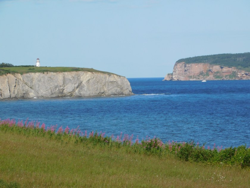
For the first few days I would be traveling on the Gaspé Peninsula:

IMG_20190816_213244669

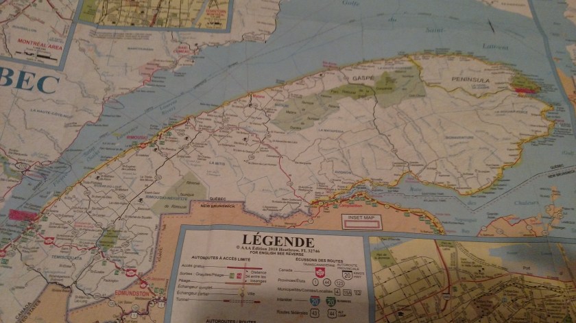
My destination on Monday was the town of Gaspé, highlighted in pink in the upper right hand corner of the map above.  After two nights there I would drive to Rivière-du-Loup, highlighted in pink in the lower left corner.

The proper term for the Gaspé Peninsula is Gaspésie, which is French for “high gas prices”.  Noooooo, I’m kidding (not about the gas prices, unfortunately, but about the meaning of the name).

Gaspé, pronounced GASP-a (a hard, or long A), or GASP-eh if you prefer (see, that eh? comes in handy sometimes) is French for “a short, quick breath taken in through the mouth”.   Noooooo, I’m kidding again.  Gaspé is derived from the Mi’kmaq word gespe’g, meaning “end,” as in “we’ve reached the end of the land”.  The Mi’kmaq, as you may recall from earlier posts, are the indigenous people in many of the Maritime provinces, as well as on this peninsula and even down into parts of the US state of Maine.

Gaspésie is the blue peninsula located north of New Brunswick province, colored in light green in the first map above.

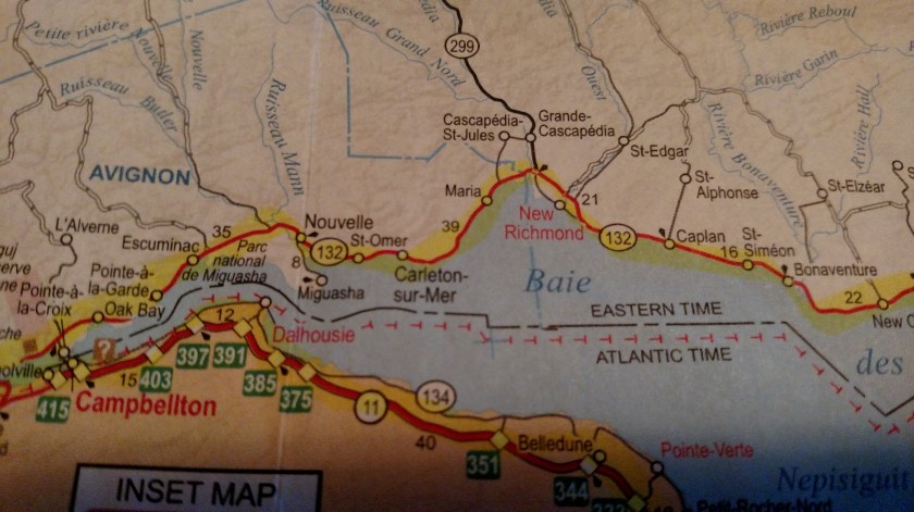
When I left Tracadie-Sheila, NB Monday morning I drove north briefly, then west along the entire north coast of New Brunswick until I got to the town of Campbellton.  There I took a bridge across the Restigouche River to the town of Pointe-à-la-Croix in QP.

IMG_20190812_112232976

I was surprised to learn that once I crossed the bridge I was now back in the Eastern Time Zone – even though Gaspésie extends all the way east above New Brunswick (on the map) which operates on Atlantic time- as do Nova Scotia, below New Brunswick, and Prince Edward Island, east of New Brunswick.  Gaspésie, on the globe, evidently slopes upward due to curvature of the Earth (that’s my story and I’m sticking to it).

I noticed something along that drive getting to the bridge which will affect the “Three Things” about each province (lasting impressions, if you will) which I plan to announce at the end of this trip.  I have already formulated my 3 things for QP – Fast drivers, fast drivers and fast drivers.

Up to the day I drove west to enter QP the Canadian drivers were quite well behaved.  I pretty much drive the speed limit these days, especially in new places because I don’t know how generous the police are with enforcement, and the other drivers were pretty much content to do the same.  I even remember thinking, a few days after entering Canada back on July 12 that, gee, I always thought Canadians drove fast.  Well…… the day I drove over to enter QP car after car went flying past me.  Then it occurred to me – all those Canadian cars which always passed me on the I-81 and I-95 corridors in the US over the years probably had Québec license plates.  Monday the QP drivers all had their undies in a bunch trying to get back to QP at warp speed.  And now that I’m here it’s even worse!

Boy do they drive fast.  They are possessed.


On another note, I apologize for not making more posts last night after my first day walking around Québec City.  A) My Fitbit tells me I took 23,802 steps yesterday and I was tired, and more importantly B) When I went to download my photos from the day to my laptop, which I do every night, for backup purposes as well as to post to the blog, I PANICKED when all the photos on my smartphone appeared to be gone!  I could see that they were there but my normal procedure to copy them to the computer ignored them.  I had this happen once before in Colorado and I was able to recover some of them on that occasion from the mysterious “Cloud,” which I still don’t quite understand.  I know what it is but the logistics of access baffle me.  After about an hour and a half of research trying to remember how I did it before (and I’m still not sure I ever got all of them), and trying to follow online instructions which I couldn’t replicate in real life, I finally figured out a different way to get them moved to a new folder on the laptop.

Whew, that was close!!

After I got that issue fixed I listened to the NASCAR Xfinity race from Bristol, Tennessee on my computer, then went to bed.  I had hoped to find a sports bar to watch the Cup race tonight (my Airbnb host doesn’t have TV service) and although my host gave me the name of a place which televises sporting events their website doesn’t mention NASCAR.  There is actually a store downtown which sells NASCAR stuff and I’m going to inquire there if they know of a place nearby which will show the race.  I thought it was going to be broadcast on NBC which, even though I’m in Canada, might stand a chance of being televised here but it is, in fact, on the goofy NBCSN (Sports Network) which many places  in the US don’t even carry.