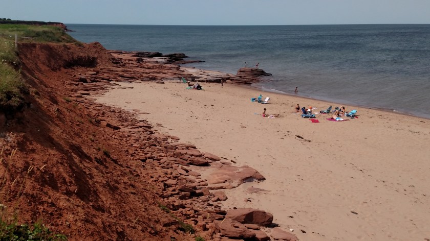
Look what I caught Dave doing…

August 9, 2019

Friday, as I was driving north on busy Route 11 in extreme eastern New Brunswick province as I traveled between the Confederation Bridge exiting PEI and my next Airbnb stop in Miramichi, NB this is what I saw heading south along the shoulder of the two-lane highway:

IMG_20190809_112623518

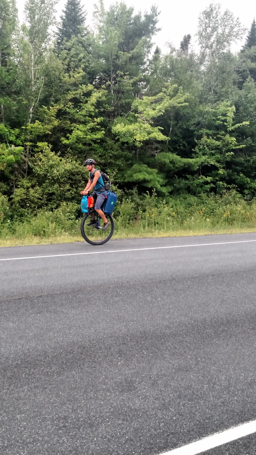
I turned the car around, drove out ahead of this guy and turned around again, parking just off the northbound side of the highway (so he wouldn’t have to navigate around my car).  I threw on my Safety Sam vest, grabbed the smartphone and waited for him to go past me on the other side of the highway.  Unfortunately traffic was approaching from both directions but as I took the shot I yelled “I’m putting you on my blog!”.   Well damned if he didn’t slow down, cross over to my side and come back towards me, taking out his earbuds in the process.

Meet Dave, a VERY personable young man from Newfoundland.  Dave is riding his large unicycle across Canada!  We talked for about 10 or 15 minutes and he was fascinating.

IMG_20190809_113835334_HDR

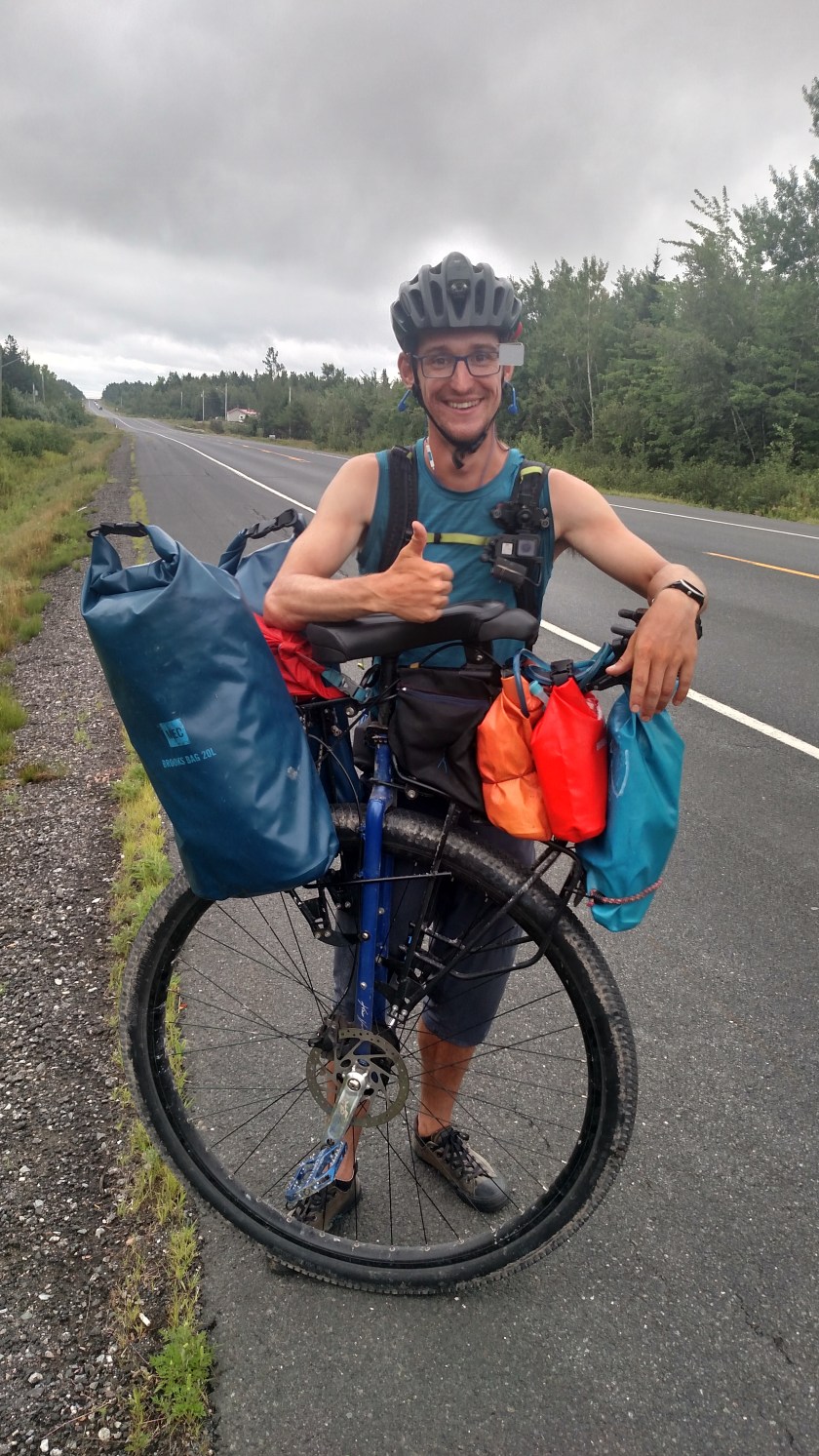
He also asked me to photograph his backpack which has his “handle,” #unicycledave.

IMG_20190809_113848480_HDR

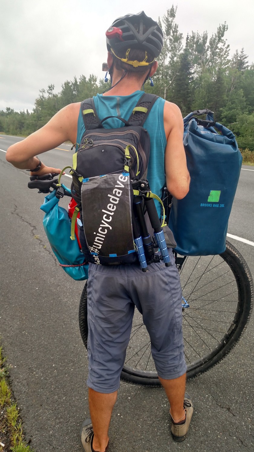
I believe he said he posts on Facebook and Instagram but I haven’t had a chance to check out either one yet.  He was wearing a camera (don’t know if it is streaming or time lapse still shots).  I shared my blog information with him and hope we may be able to talk again sometime at greater length.

He said he averages around 100 km (60 miles) per day and is heading back towards Newfoundland after having been up north of the Great Lakes (he actually started much further west according to his website).  He suggested that I budget lots of time north of Lake Superior when I get over to that part if Canada as he says it is amazing.

What incredible luck to have encountered him, and that he actually stopped to chat!


UPDATE:  I saw Dave again on Saturday!  I had driven back down south on Route 11 as far as Shediac and then went east out to the coast to actually drive the scenic road I had planned to do Friday before having tire problems.  About the time I got to Boutouche, this time of the Acadian Shore Drive, there he was.  It had just rained and he had a blue parka-type coat on over top his riding outfit.  His goal today Saturday was to make it all the way down to Hopewell Rocks to watch the tide go in and out.

I asked about the camera and he said he mainly shoots video but sometimes, if on a tedious, repetitive stretch of road he will do time lapse still shots to save storage.

Prince Edward Island – Day One

August 8, 2019

This post contains photos taken on Thursday while on PEI which have not appeared in other posts.  These are pretty much in order and cover a variety of places and topics.

PEI is a long island which kind of slants from northwest to southeast but to make direction references more succinct I will use north/south/east/west.  There are three main sections, west, central and east.  I believe I read that the island is about 175 miles long but I will verify that and may change the number after I post this. CONFIRMED

IMG_20190810_074135102

I had scenic roads plotted all over the island (my primary roads, from the book I am using as a guide, are always highlighted in orange) but since my visit was cut short from four days to effectively one I had to prioritize my to-do list and try to maximize my time there.  I was staying in the southeastern coast of the central section (highlighted in pink).  The roads I decided to focus on were in the western section.  I did not go to the eastern section at all.

I started out fairly early Thursday and drove back towards the Confederation Bridge.  The weather was not conducive to me getting good photos there so I moved on to Summerside, the second largest city on the island which is located at the point where the central section meets the western section.  I spent some time and took some photos there but am not happy with how they turned out.  I then drove along my first scenic road, Route 11, on the southern coast of the western section of the island.  This is where I happened upon the Acadian village where the big celebration is taking place (see separate post).

When I reached the northern end of Route 11 I decided to cross the island to the north coast and go back east on scenic Route 12.  I was planning to have lunch at a restaurant in the central section so that is why I changed direction.

This boat was along one of the small roads I was using to go from south to north.  It is a large fishing boat in someone’s yard.

IMG_20190808_112055933_HDR

This is an elementary school playground in little Ellerslie, PE.  Evidently their schools colors are maroon and white, eh?

IMG_20190808_112645064

Just a few hundred feet from that playground I was quite surprised to see this sign on a large metal building.  Ellerslie has a population of less than 500 people and is a good distance from the two largest cities on the island, Charlottetown and Summerside.  While Escape Rooms are all the rage right now I find it hard to believe this was a good location location location….

IMG_20190808_112919004

This is another beautiful church I found in my travels on the north coast.  It is Saint Patrick’s Roman Catholic Church.  It was out in the boonies so I don’t know exactly what town it is in.  I had seen another, almost identical building but white with red stripes on the steeple, which I drove past every day I was on the island as I left home and drove west but when I got close to it I saw that it badly needed a paint job and had fallen somewhat into disrepair.  This one, however, looked very nice.

DSCN8621

As I was getting into position to take the church picture I saw this large prop plane taking off from an airfield facing the opposite side of the road.  I was using my digital camera and took quite a few shots with the zoom lens as the plane banked and turned to it’s right.  When I was done with the sequence I realized a woman had stopped her car in the road as she didn’t want to interfere with my shots.  Canadians are so considerate!  I waved to thank her but wish I could have spoken with her briefly as well.

DSCN8608

DSCN8612

Next I headed to the restaurant in North Rustico Beach on the north coast of the center section.  It was PACKED, with a long line out the door.  I didn’t even bother to park the car (not that I would have found a spot anyway) so I headed off to the Anne of Green Gables house to the west and decided I’d try again later.  I did stop at a waterside boardwalk nearby to take a photo of this tourist fishing boat group going out to sea while avoiding a group of kayakers paddling in the harbor.

DSCN8639

After the Anne of Green Gales house (see separate post) I drove back east through a portion of nearby Prince Edward Island National Park, a long, thin Park which is mostly a controlled access scenic drive high above but very close to the water, which is the Gulf of Saint Lawrence looking north from anywhere on the island.  From the south coast of the island one looks out over the Northumberland Strait which is the body of water the Confederation Bridge spans.  I read that nowhere on Prince Edward Island are you more than 10 miles from at least one of those two bodies of water.

IMG_20190808_141340844

IMG_20190808_141330493

PEI is famous for it’s red dirt and red sand beaches.

DSCN8649

DSCN8651

I will be posting more about PEI in the future.


Anne of Green Gables

August 9, 2019

Thursday, while driving on some of my “primary” scenic roads on Prince Edward Island, I visited the town of Cavendish, on the northwest coast.  There I found the house which inspired the children’s classic (insert title of post here…) written by Lucy Maud Montgomery is 1908.  Parents of young girls from all over the world bring them here to visit (and I’m sure many adults who enjoyed the book as a child come here as well).  I came here at the request of a friend in Durham (an adult) who badly wanted a photo of the house.  She was ecstatic that I made it here when texted her a photo yesterday afternoon.

IMG_20190808_133359234_HDR

IMG_20190808_133641321

IMG_20190808_133636122

And this is Anne:

IMG_20190808_133844902

No, really, that is Anne.  At least that’s what she told me.

Inside the Visitor Center is an area where young girls (and maybe even older girls or adults) can don a red wig with pigtails, a period dress and straw hat and have their photo taken in front of backdrop while holding a sign which says “Green Gables”.  The backdrop isn’t even a painting or enlarged photo of the house, just some artistic scene.  I thought that whole thing was kind of lame considering what their parents had to pay to get them here and get them in to see the house.

So Anne is another photo op and a chance for these little girls to me misled thinking they really met Anne of Green Gables.  I took a photo of one such young girl having their photo taken by her parents and when the girl had removed all the props I asked the parents if it was ok to post the photo on the blog.  They said they preferred not, which I fully understand and is the reason I always ask.  I had a similar situation in a big National Park in the western US and, again, was told no.

So anyway, I see “Anne” (wink, wink) chatting and posing with some young girls near the back of the house and when the visitors moved away and their daughter was out of earshot I said “So you work here?” leading up to the question as to whether or not I could post her photo on the blog.  She replied, in a perky, whimsical voice – “No, I’m Anne…. I live here” and employed the sweeping hand motion I’m sure she has had plenty of practice doing.  Bless her heart, she’ll probably grow up to have psychological issues.  At least the people in the Mickey Mouse costume at Disney World get to wear a mask.

Oops – perhaps I should have warned “Spoiler Alert”…..

This property, while technically not a National Park, is a Canadian Historic Site and, as such, is managed by Parks Canada.  Sounds like a great spot for the “red chairs” and sure enough, I found them tucked away behind a row of hedges near the front yard of the house.

IMG_20190808_133416718_HDR

Here is the view the two young ladies seated in the chairs were enjoying:

IMG_20190808_133508825_HDR

The open field in the distance is now one of the fairways of a golf course.  Somehow I doubt that was in the book.

Fore!

Seeing as the site was managed by Parks Canada my Discovery Park Pass got me in for free, which was a relief for two reasons.  One, I didn’t have to pay, of course, but more importantly two, I didn’t have to wait in the loooooong line of parents waiting to bring their little girls in.