Glacier National Park

You’ll probably be seeing lots of mountain-only pictures the next day or two so I thought I’d start with some that have water as well.  I saw two big lakes today, one on the east side (Saint Mary Lake) and one on the west side (Lake McDonald).

I am staying in Kalispell, a little town about 30 miles west of the west entrance.  Thursday I head over to Coeur d’Alene in northern Idaho for 4 nights.

Glacier National Park

I arrived at the east entrance of Glacier about 5 PM local time.  I drove through the park east to west on “Going to the Sun Road”.  The road was only fully opened to traffic about 3 weeks ago (when I checked the Park website in late June they were still plowing snow at the highest point!).  I’m going to stop tomorrow to ask exactly what date it reopened.  It took me a little over two hours to drive the 50 miles to the west entrance.  I did stop to take a bunch of pictures, though, so a non-stop drive should take less time.  Not as much traffic disruption with people (myself included) stopping to gawk at animals as there was in Yellowstone.  The big problem here is that the parking lots fill up early in the day (largely with hikers who leave their car all day).  There is a free shuttle which I may use tomorrow afternoon depending on how things look traffic and parking-wise in the morning.  I’m hoping my being here during the week will help keep the crowds down.

There are not as many wildlife spotting opportunities at this park due to the size of the mountains and the placement of the road.  Typical, curvy mountain road with very narrow lanes.  The driver must really pay attention as rocks jut out very close to the travel lane.  There are lots and lots of places to pull over and admire the view.  I actually put my “Safety Sam” vest on because I had on a dark shirt and sometimes walked along the road to get to a good photo vantage point.

My first impression of Glacier is… WOW!  I only spent a little over two hours in the Park and already have enough blogworthy pictures to last over a week.  And I’m here two more days!  I plan to go in early tomorrow and get back over to the east entrance, then turn right around and drive it westward again – this time with the sun behind me.  I’ll be stopping a lot to take pictures, use my binoculars, and just take in the views.  Anyone who enjoys beautiful places needs to put this not only on their bucket list, but on their short list.

Does anyone remember these?

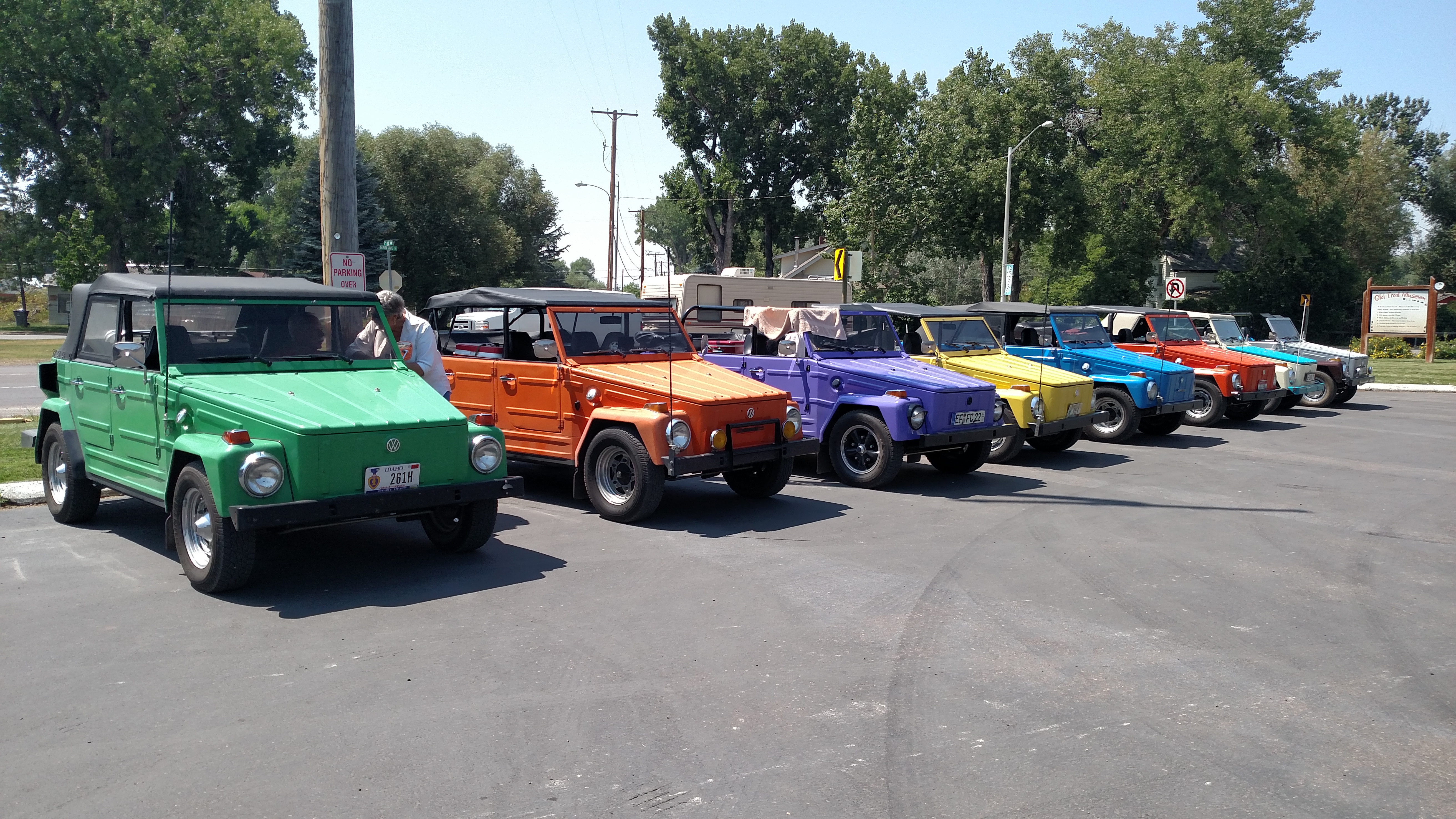
I was driving down a scenic road near Darby, MT the other day and from the opposite direction came a parade of 8 Volkswagen “Things”, each a different color.  I thought “How cool is that” and actually considered turning around to follow them to see if they were going to a car show or something.

Well this afternoon on my way to Glacier, here they all were lined up in an ice cream drive-in parking lot in Choteau, MT.  I spoke with the woman standing next the green Thing and she said they are from Boise, ID (where I’ll be in a few weeks) but do road trips en masse from time to time.

The VW Thing, as it was called in this country, was sold in the early 70’s.  I saw one last year in a city somewhere (I forget which one) but rarely see them on the road.  In Germany they were sold as the VW Type 181 (oh, those wacky Germans….).

********

Also on the road today I stopped in the little town of White Sulphur Springs to refill my water bottles (again). My friends Eric and Shawn gave me a plug-in cooler which sits on the floor on the passenger side of the car.  I keep 12 bottles of water in it and it keeps them cool as I drive.  My brother David, who lived in Salt Lake City for several years, taught me the importance of staying hydrated in the desert and/or at high elevation.  I buy big bottles of water at the dollar store and refill the little bottles with that.  I know you aren’t supposed to reuse bottles indefinitely.  I usually start each trip with a new set.  Given the length of this trip I will probably replace them about halfway through my journey.  Having the cooler sure beats buying ice for my Igloo every third day.

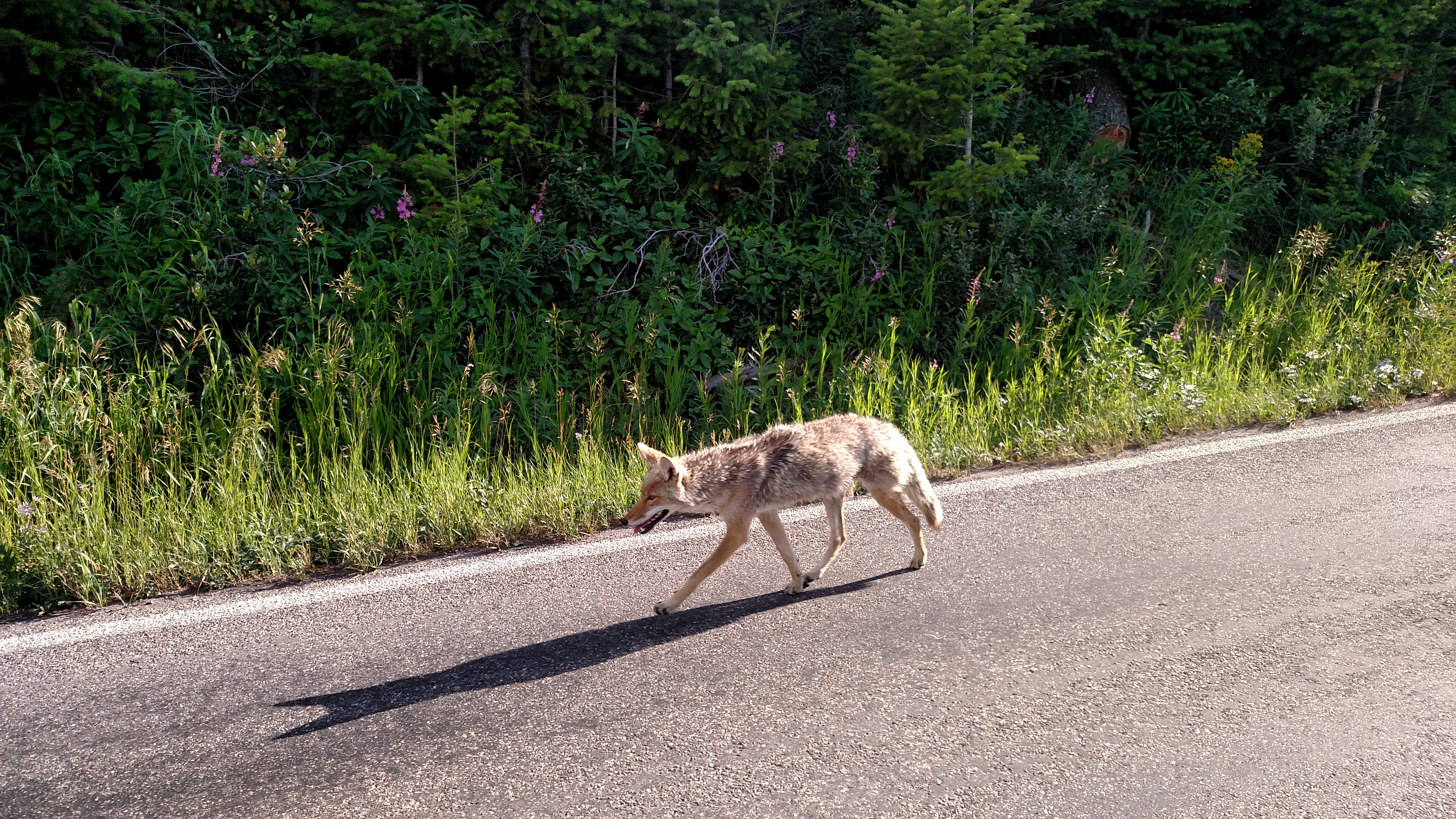
The only critter I came across today was a Moo Cow which was crossing the road in the mountains leading up to Glacier.  She was crossing the road as I came around a turn, but there was a car in front of me and we were already going pretty slow so it was no problem.

Want to play fetch?

Meet my new best buddy Regan.  I am staying at his house while in Bozeman.  Regan LOVES to play fetch with a tennis ball.  He will do it non-stop if you let him.  His next favorite thing to do is play tug-o-war with the yellow thingie on the porch step, or an old blue frisbee (and he’s very good at it).  I’ll miss his wanting me to go outside to play.  I got up about 5 this morning to get a drink of water and he came padding out into the kitchen with his tennis ball.  Too early, Regan!

Final day in Yellowstone

Today was “loose-ends day” when I try to tackle anything on my agenda that I haven’t gotten to yet.  Well I had pretty much done everything I planned to so I decided to drive east of Yellowstone to an area I had driven through the first day but take some different roads once I got there.  Then, on the way home, I entered Yellowstone at the east entrance and went west through the northern part of the Park to leave via the north entrance.

Saw lots more bison, including a big one right next to the road, walking parallel to it on my side.  I was the only car on the road when I saw him so I quick turned around and got a few pictures.  At one point he walked out in the road and stopped (again, parallel to the flow of traffic).  I tried to get a picture in my rear view mirror but when I put the phone up there all I could get a picture of was the phone!  The best laid plans…..

I saw several female moose and a few calves today as well.  As I was getting close to the exit traffic stopped and I saw this guy trotting down the other lane towards me.  When I first saw him he was probably 6 car lengths ahead of me and I assumed he’d probably duck into the vegetation by the side of the road before he got to me but he just kept on coming and waltzed right past me.

Snake River

Sunday I got my first glimpse of the Snake River.  This picture if from up near the easternmost tip of Jackson Lake in Grand Teton National Park and is looking back towards some of the northernmost mountains in the Teton range.  You (and I) will be seeing lots more of the Snake River later in this trip as I zig-zag across the northwest.  It looks calm and tranquil here but will get pretty ferocious further on down the line.

I did see two people kayaking to the left of where this picture was taken.  They are the only people actually kayaking that I have seen so far (though I see lots of kayaks on vehicles).  The rivers and streams up in Yellowstone and in other parts of Montana were moving along at a pretty good clip and while kayaking downstream would be fun, I think trying to paddle upstream would be a challenge.  The water is quite cold and swimming is discouraged.

I have also seen lots and lots of people fly fishing during my time in Wyoming and Montana.  I’m sure folks fishing the Snake River are trying to catch a coveted Snake River fine-spotted cutthroat trout.

I’ll be staying in Rexburg ID in a few weeks and may get a chance to get back up to Grand Teton National Park at that time.  The Park is in the northwest corner of Wyoming and is about 10 miles south of Yellowstone.

Grand Teton National Park


You get a twofer on this one.  Sunday I drove down west of Yellowstone and through a portion of southeast Idaho before crossing over to Jackson, Wyoming.  The town itself is named Jackson.  The valley between the Teton and Gros Ventre mountain ranges is what is known as Jackson Hole.  Just north of Jackson is Grand Teton National Park.  The mountains stretch for 40 miles.  I posted the top picture to try and capture the length of the range (and you are only seeing a portion).  The bottom picture shows how rugged these mountains are.

In the middle of the bottom picture is Grand Teton, which tops out at a whopping 13,770 feet.  To the left is Middle Teton and to the right is Mount Owen.  Even at 13,770 feet Grand Teton is not the highest point in Wyoming.  That honor goes to Gannett Peak at 13,809 feet.  It is located a little bit southeast of the Teton range.

The accessible part of the National Park lies to the east of the mountains.  The main road through the park runs pretty much parallel to them until reaching a series of lakes, at which point it starts getting further away.  There are no roads in the mountains themselves.  So visitors basically travel the main road and see the mountains from varying perspectives.  There is a bicycle path which runs parallel to Teton Park Road and I saw many, many bikers (it is fairly level, unlike the roads in most National Parks).  There are lots of trails which branch out between the road and the mountains.

There are two small lakes, Jenny Lake and Leigh Lake, which are south of the largest lake, Jackson Lake up near the north end of the range.  There are also two small lakes located east of Jackson Lake, Two Ocean Lake and Emma Matilda Lake.  There are several lodges at various points in the Park, as well as several campsites.