Cape Spear

August 1, 2019

Thursday afternoon I drove out to Cape Spear, southeast of St. John’s.  It was a beautiful drive out and along the way I saw this gorgeous tree next to the road. I have no idea what it is.

UPDATE – I had no idea…  Now I do!! A good friend from back in Durham informed me that it is a False Acacia, which he learned from the lyrics of a beautiful song by an Argentinian folk singer.  My friend, who’s from Italy, is studying music and composes music.

IMG_20190801_124530242_HDR

IMG_20190801_124548199

Once I made it out to the Cape (the easternmost point in North America) I enjoyed another twofer – there were two lighthouses, the current one which as you will see is still operational, and the original one, shorter but higher up on the hill, which has been recently restored.

DSCN8477

IMG_20190801_130830807

It took me a lot of tries to get the timing right and catch the green light.  Ah, the beauty of digital cameras where you can just click, click, click and then eliminate the bad shots.  That is one reason I take so many pictures in a day – many are duplicates to try and ensure I get a good one out of the bunch.

DSCN8468

DSCN8470

While I was out there taking photos the big yellow Air & Sea Rescue helicopter I had seen up in Gander flew down the coast from the north and made a wide circle around the tall lighthouse (photobombing everyone taking selfies). It flew back north and made another orbit over the open water before flying away.

DSCN8440

DSCN8443

DSCN8447

IMG_20190801_125909384

DSCN8449

DSCN8454


Signal Hill in St. John’s, NL

August 1, 2019


Thursday morning I drove in to St. John’s, only about 8 miles from where I was staying in Torbay. After walking around town to get acquainted with the many restaurants and shops, and looking at some of the large boats in the harbor (including the blue one which was just arriving), I drove up to a large park called Signal Hill, high above the city. The structure at the top of the hill is Cabot Tower and is visible for miles away from town.

DSCN8423

DSCN8419

DSCN8421

DSCN8422

As you would imagine, the view from atop the hill is spectacular.

This is looking down towards the downtown area and harbor:

IMG_20190801_111732108

DSCN8427

This is looking northwest, towards the airport and the town of Torbay where I was staying:

IMG_20190801_110750410

I didn’t get a map of the park itself so I don’t know what all the various structures in the park are but you could see the lighthouse, way down close to the water:

IMG_20190801_111325042_HDR

DSCN8415

And a walking path which goes down to a huge rocky area, also close to the water:

IMG_20190801_111332885_HDR

I didn’t go down to either one because I’d then have to come back UP.

Looking down towards the museum and Visitor Center (and the road I had driven up on) is an area where people were sitting on bleachers watching reenactments of various things. The people in period costumes (uniforms) would periodically fire off the big cannon or shoot their weapons (blanks, I’m sure).

DSCN8409

There was also an area where you could see cannons aligned to protect the harbor from intruders.

DSCN8424

And this was the “Powder Room,” I mean “Powder House,” where gunpowder was stored away from the main building:

IMG_20190801_111532041

What did you learn today?

August 5, 2019

I learned, much to my dismay (selfishly), that today is Civic Day in Nova Scotia, Canada.

Nova_Scotia flag

(Photo credit: flagmartcanada.com)

I know this because my car broke down last night after I got off the ferry and most businesses (including car mechanics) are CLOSED today.  An inconvenience for me, but there are many positive aspects of it.  It happened in a gas station parking lot, not on the road (and not out in the middle of nowhere in a spot with no cell service and no place to walk to for help (and perhaps very little traffic)), the weather ended up being ok and not stormy, I was able to get in the same Airbnb I stayed in for three nights before taking the ferry north 10 days ago (there were people with reservations but they cancelled), and it is nice today so I walked to the store for two days worth of food.  My original hostesses, one over in Sydney, where I was supposed to stay last night, and one for the first of 4 nights in the same house over on Prince Edward Island, were very understanding.  The woman in Sydney even offered to come get me, and tried to help diagnose the problem over the phone!  CAA (the Canadian equivalent of AAA Motor Club) towed me to a garage within walking distance of where I am staying and I will be there bright and early when they open at 730am tomorrow.

Someone told me last night that today was Boxing Day in Canada but that is, in fact, the day after Christmas.  Civic Day is celebrated in certain Canadian provinces on various dates based on each province’s “birthday” or other significant event.

So HAPPY CIVIC DAY Nova Scotia – I will celebrate it by getting caught up on my blog!!


More Jellybean Houses

August 1 & 2, 2019

Here are more of the colorful Jellybean Houses I saw while in St. John’s last Thursday and Friday (see previous post).  These were in spots where utility poles and wires distracted somewhat from their beauty.

IMG_20190801_103737486

IMG_20190801_113758855

IMG_20190801_115151480

IMG_20190802_093513132

IMG_20190802_095337338_HDR

IMG_20190802_095700993

In this environment even a white house looks great:

IMG_20190802_095731660

And evidently some folks paint their stairs & railings and put pretty flowers out – and some don’t:

IMG_20190802_100238805_HDR


Jellybean Houses – St. John’s, NL

August 1 & 2, 2019

Thursday and Friday I spent the day in and around the large town of St. John’s in northeast Newfoundland. This is one of the posters currently being distributed by the Visitor’s Bureau promoting the town.

IMG_20190803_111530915

These are called Jellybean Houses because of their color and variety.  They actually call it Jellybean Row (because they are rowhouses) but that isn’t an actual place, just the concept.  These colorful houses are everywhere in the city of St. John’s.  I took lots of photos, and could have taken lots more, but I will try to only share the better ones. While the pictures on the posters are pristine and clear of vehicles and utility poles & wires, real life is a little messier.  I do have some relatively “clean” shots which I will post first, followed by more cluttered shots in another post. Many of the residents plant pretty flowers which often complement the color of the house and it is unfortunate that parked cars often block the view of them.  I guess we can’t all live in Disneyland…..

IMG_20190801_113910457

I tried to take photos of the houses on the sunny side of the street, though sometimes I took them of the shady side but at an angle so the sun wouldn’t distort the shot.  You will also notice that many buildings are level, whereas others are staggered in height, sometimes quite a bit.  The streets parallel to the waterfront in St. John’s increase in altitude very quickly and walking up or downhill is very steep, like being in San Francisco.

IMG_20190801_114021689

IMG_20190801_094126145_HDR

IMG_20190801_115308688

I waited in the shade across the street in front of this yellow house for a few minutes as a well dressed man methodically scraped at a sticker on the door using his fingernail. When it became apparent it was going to take a while I decided to go elsewhere and come back later. I walked to his side and commented “that looks tedious” not to be a wiseass but just to acknowledge his effort. He explained that he owns this house and just had a new front door unit installed, with glass side windows. He basically said “You’d think that for $ 4,000 they would have at least removed the barcode!”.

IMG_20190801_120148562

I did come back later and as you can see, remnants of the sticker are still there.

More houses:

IMG_20190801_120230989

If you look closely at the blue house in the photo above you will see that even the mailboxes have multi-colored house designs on them.  This was what I was referring to in a post I made several days ago of an old building located in a fishing town with one of the sides painted to emulate the Jellybean Row concept.

IMG_20190801_120324240

IMG_20190801_121425337

IMG_20190802_093424261

IMG_20190802_094700178_HDR

IMG_20190802_100032542_HDR

I saw many other things in St. John’s which I will address in other posts.


Southern Avalon Peninsula, NL

July 31, 2019

IMG_20190802_180225860

After visiting Salmonier Wildlife Park I continued south on Route 90, driving the “Irish Loop”.  Newfoundland has many scenic drives indicated on their provincial map and they all have names and pictures to keep you on course while traversing them. Canadians like pictures on signs, not just words and numbers.

It was a beautiful drive, most of it inland until I got down to the southern tip of the peninsula near the town of Trepassey.  Then I was near the water and for the first time this trip – coastal fog. I am actually quite surprised that as close as I have been to water for the past three weeks that I haven’t encountered more fog.

On the southeast end of the peninsula I stopped in at Mistaken Point Ecological Reserve, which includes the lighthouse out on Cape Race.  It was here (just a lighthouse and communications shack at that time) that a radio operator received the CQD call from the Titanic.

CQ is a radio communications term, still used by amateur “ham” radio enthusiasts, meaning “General Call”.  Operators will sometimes broadcast that general call and talk (either by voice or using Morse Code, as Titanic did) with whomever answers. CQD means “General Call – Distress” and pre-dates the now more commonly used emergency call SOS.

This is the lighthouse at Cape Race:

IMG_20190731_161816409

Let’s try that again – THIS is the lighthouse at Cape Race:

IMG_20190731_162746131

As I was driving back out to the highway from the lighthouse I saw this waterfall not far from the gravel road I was driving on:

DSCN8407

As you can see, it was a nice day but for the fog by this part of the Atlantic Ocean.

I continued north on what had now become Route 10 and saw signs for the S.S. Florizel disaster. Not knowing anything about it, I stopped to take a photo of the view from the memorial site and read a brief recap of the event.

IMG_20190731_172156094

On February 23, 1918 the S.S. Florizel set sail from St. John’s, Newfoundland (my destination for the night, north of where this happened) headed for Halifax, Nova Scotia and ultimately New York City.  It was the flagship of the Red Cross Line, one of the first ships specifically designed and built to operate in icy seas.  On board were 138 passengers and crew.

Florizel-Ice


(Photo credit: beothic.blogspot.com)

The journey began at night and the Captain gave orders to get out to the open sea and sail south at full speed. It was very stormy and they couldn’t see any of the lighthouses to let them know where they were. This was obviously before radar and GPS.

After considerable time had passed the Captain ordered that the ship be turned west, assuming they had cleared Cape Race. After the accident the Captain was charged with neglect, but was later cleared when it became known that the Chief Engineer, who controlled the ship’s speed, had ignored the order to operate at full speed at the outset because he wanted to delay the arrival and force the stopover in Halifax to take place overnight so he could visit his family. Consequently they weren’t nearly as far south as the Captain assumed they were and they sailed directly into the rocky coast near the small town of Cappahayden.  The ship hit the rocks at approximately 450am local time on the 24th.

Florizel-wrecked

(Photo credit: facebook.com)

Once the townspeople were made aware of the accident, and at first light a short time after it had occurred, residents and rescue workers watched helplessly from the shore as the passengers and crew flung themselves into the frigid water.  94 people died.

A brief moment of silence, please…..


I continued north and when I got to Ferryland saw this great view (a restaurant just to my right as I took this photo was understandably called “Million Dollar View”):

IMG_20190731_175106631

I continued on north to my ultimate destination of St. John’s, where I would be spending the next three nights.


How’s it goin’, eh?

August 5, 2019

After more than three weeks in Canada I finally heard a Canadian utter the interjection “eh?” at the end of a sentence!  For those of who are too young or not familiar with the skits that Canadian comedians Rick Moranis and Dave Thomas used to do on SCTV back in the early 1980’s (there are lots of them available on YouTube.  They’re hilarious), at the beginning of each 2-minute episode of “Great White North,” their skit, Moranis would say “G’day everyone, I’m Bob McKenzie and this is my brother Doug” – at which point Thomas would always say “How’s it goin’, eh?”.  Like the “Weekend News” segment on Saturday Night Live, or Seth Meyer’s “A Closer Look”  segment, their bit was something I’d always stay up to watch on late night TV.

McKenzieBrothers

(Photo credit: mentalfloss.com)

As I was preparing to disembark from the ferry which brought me back to Nova Scotia yesterday I overheard the young man who had prepared my smoothie earlier in the day at the little snack bar on Deck 9 of the ship say “So, you finally found a box of paper straws for me, eh?”  to a co-worker.  I’ve been wanting to post about this since the beginning of my trip but was waiting for the right time.

And I’ve only heard one “aboot” so far during this trip.  That was uttered during a conversation I was having with the kid in Truro, NS at the Tidal Bore place aboot three weeks ago (as Shawn would say – Ha!).  He was giving me directions to a restaurant he was recommending and said to go “aboot” 4 kilometers up a certain road.  I never knew Peter Jennings, the late anchor of the weeknight ABC News broadcasts, was Canadian until I heard him say “aboot” one night during a story.

PLEASE understand, I’m not making fun of Canadians, or if you think I am it is good natured fun.  My mother was from West Virginia and I can say “y’all” with the best of ’em.  And I have added “fixin”” to my vocabulary since moving to North Carolina.  I’m sure other people have observed that about me, too.

Hey – different is what makes the world go ’round….


Photo added 8/6/2019 after original post

I was in Walmart today to buy a fire extinguisher for my car (see separate post) and saw this:

IMG_20190806_114224625


No Parking!!!


August 2, 2019

Friday morning I drove back in to St. John’s to take more photos (and eat more yummy food) and I decided to park way up on one of the higher residential streets and gradually work my way down to the water. I found a street with a 2-hour free parking zone and as I pulled in to the furthest forward of two open spaces I noticed this situation which brings to mind a photo I saw online recently (and which I had seen similarly depicted a few months ago).

IMG_20190802_093013277

The parking zone sign and white line on the pavement clearly shows that this is a legitimate parking spot. But look closely – there is also a fire hydrant (and sign) near the front of the space. A dilemma.

This scenario didn’t end well for the owner of a car in Halifax, Canada about 2 weeks ago when they parked in front of a fire hydrant and, as misfortune would have it, a fire broke out nearby. The firemen broke the car windows to get the hose through the car in order to extinguish the fire.

HalifaxFireHydrant

(Photo credit: globalnews.ca)

When this was reported in the news the authorities were still deciding whether or not to reimburse the car owner for damages. Although it was a clearly marked parking spot, the presence of the fire hydrant made it a no parking zone.

I had heard of another similar event from Anaheim, California back in February but in researching this post it was evidently a “watch and learn” exercise to help inform the public.

CaliforniaFireHydrant

(Photo credit: thestar.com)

As you can see from the photo below, I moved my car BACK one space before leaving it for my walking photo shoot and eating tour, and it was thankfully intact when I returned about 2 1/2 hours later.

IMG_20190802_120225889


Why is _________ so …….?

August 4, 2019

This is a variation of something I found online while doing research for this trip.  I was looking for a map of the northeast US and the Maritime provinces of Canada to post on the blog and show, in true scale, where I was going to be.

why is dailyhive

(Photo credit dailyhive.com)

In the map above, each state, province and region has three words or phrases which were evidently gleaned from Google Incognito searches performed in the US in 2016. Enlarge and or zoom in on the map, or print it out to read the fine print.  By the way, you should be able to right-click on any of the photos I post (mine or those found online, like this one) and save them to your own computer where you may view or manipulate them.

For example, North Carolina, where I live, had these three things:

Humid, Racist, Stupid

(And let me stop right here and say that these views do NOT reflect those of JohnBoy or the blog!)

The Southeast US in general:

Poor, Religious, Humid

Some are rather humorous (check Kentucky) and some had few, if any, responses (check Labrador and the Maritimes in general).

My friends Eric and Shawn recently traveled to three countries in Europe to celebrate a milestone anniversary and I changed the rules a little and asked them to formulate three impressions about those three cities or countries based on their short time there.  I plan to do the same for the areas I am visiting and will post my thoughts on the Maritimes (individually and collectively) after I have been to PEI and have seen more of New Brunswick.  Later I will add my thoughts on the small portions of Quebec and Ontario provinces that I will be seeing before going home.

A fun little game you can play at home to pass the time between blog posts (especially since yesterday was a travel day – car, and today is another travel day – ferry).

Salmonier Nature Park

July 31, 2019

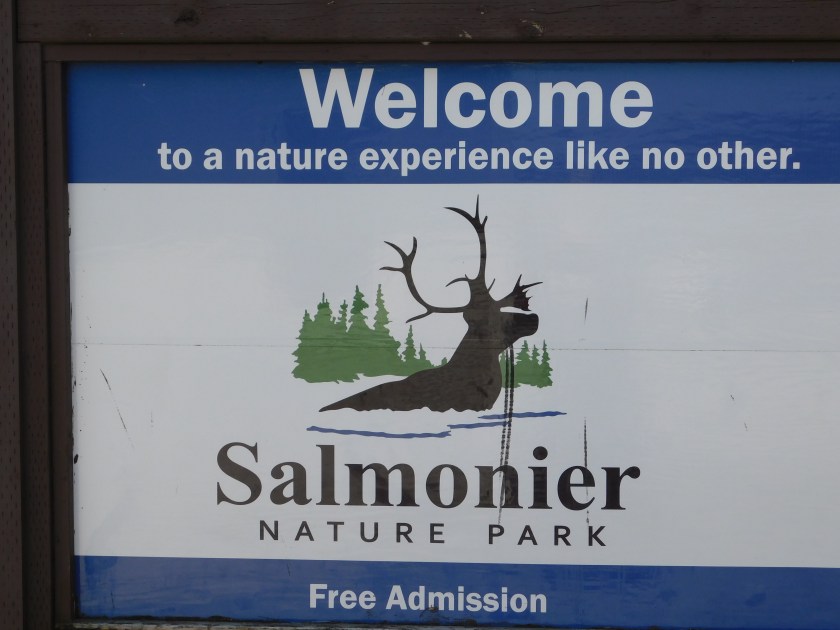
After visiting Dildo I proceeded back to the TCH and further east, then south on Route 90.  I saw signs for this Nature Park and thought I’d make a quick stop and check it out.

DSCN8383

I walked around the Visitor Center and asked the young lady at the front desk what there was to see here.  She showed me a map of the walking trail but I told her I probably wouldn’t be doing that today (historically I don’t see many animals out and about mid-day, even in a zoo).  She went on to explain what this facility is all about, and it isn’t a zoo…

The folks here at Salmonier rehabilitate injured animals and, when possible, reintroduce them to the wild.  My youngest brother lives outside of Cleveland, Ohio and twice they have taken me to a similar facility there (in a county-run park!).  The young lady explained that unlike a zoo, their animals are likely to be visible during the day but, of course, couldn’t guarantee it.  She talked me right into it.  I went back to the car to get my floppy hat (the sun was now out in full) and my digital camera.

There is a long boardwalk which meanders through the park and goes past various areas where the animals now live while recovering from their injuries.

The bird of the day was the red finch (not in for rehab, just native to the area).  Children are asked to keep an eye out and alert the staff if they see one.  I didn’t see any.

IMG_20190731_113049871

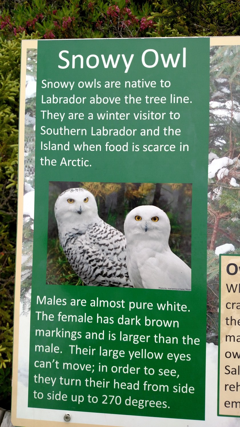
First up, this Snowy Owl:

DSCN8327

IMG_20190731_115054112

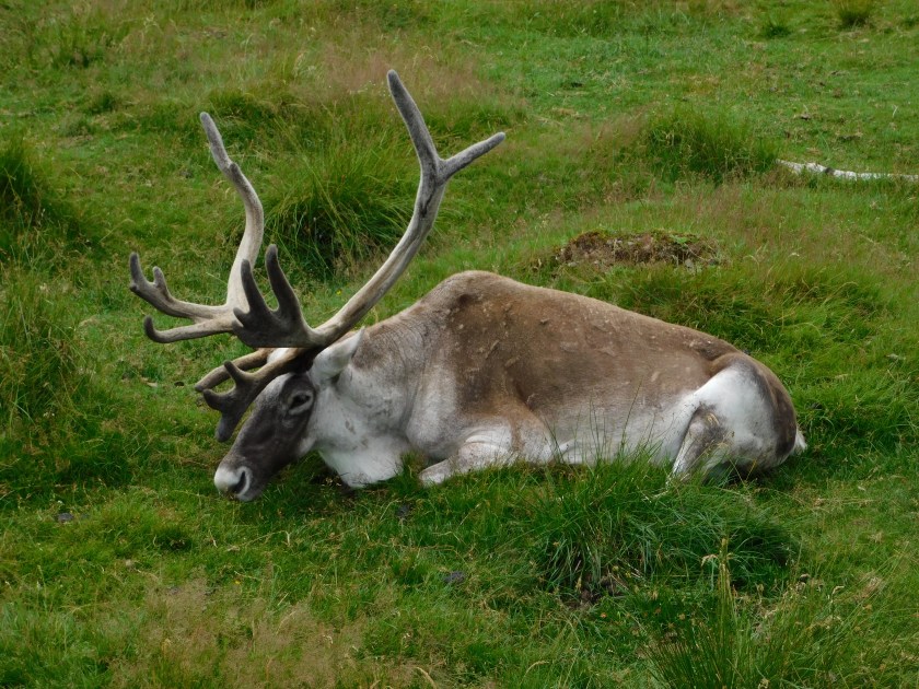
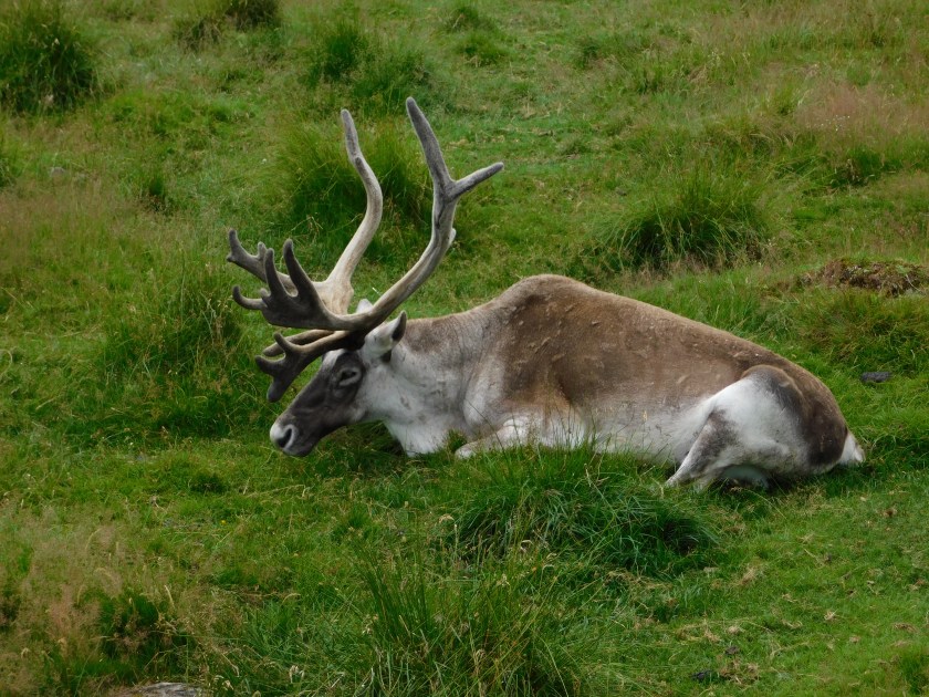
Next, the first caribou I have ever seen in person:

IMG_20190731_115436581_HDR

DSCN8328

DSCN8336

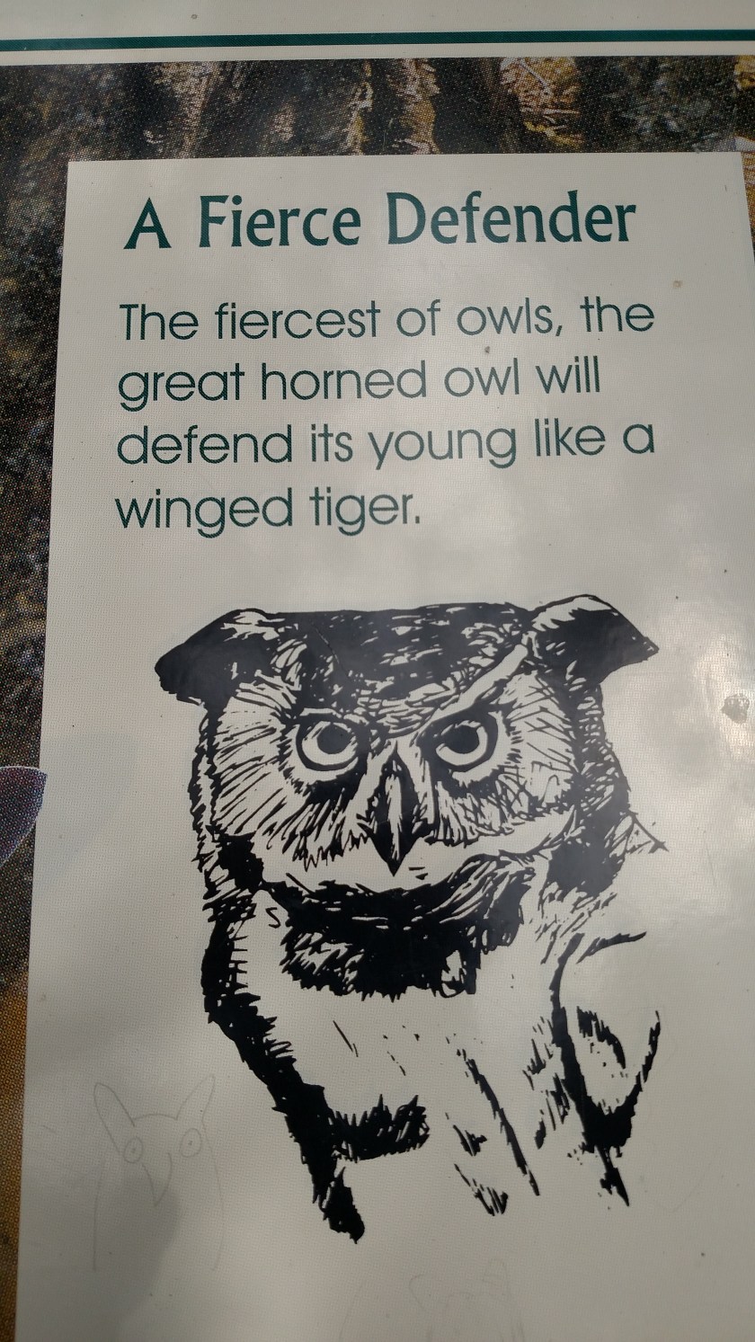
Next, a Great Horned Owl – but first, a warning:

IMG_20190731_115826822

DSCN8338

His eyes appeared to be open when I first saw him but after I moved the camera to see both eyes through the chainlink fence he had them shut in all the other photos (and his left eyelid appeared to be damaged).

DSCN8341

IMG_20190731_115956301
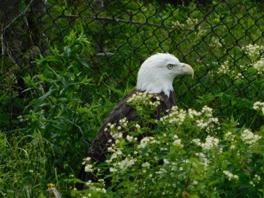
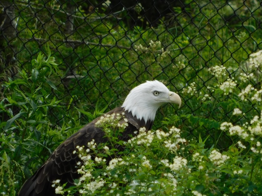
Next up, a beautiful pair of Bald Eagles:

DSCN8345

DSCN8346

DSCN8348

DSCN8349

A Peregrine Falcon, which I have seen in flight but never up close.  This one was on the ground near a tree trunk and shrubbery was hiding most of his body.

DSCN8352

DSCN8353

As we walked down the boardwalk to the next area this small bird landed on the railing.

DSCN8354

The people I had befriended during the walk knew what it was but I don’t remember what they told me.  I have looked up birds of Newfoundland but didn’t see it.  I do know it wasn’t a red finch.  It, too, was just passing through from the outside world.  …

When we got to the Newfoundland Pine Marten area the people in front of us said that it had been out running around but had gone into a box up on a pole (to hide or nap) just before we got there.  The red foxes were also hiding.

The moose were not.  I present the only two moose I’ve seen in Newfoundland – Joey and Isabella.  The young lady at the Visitor Center said that Joey often responds to his name but he was resting quite a ways from the boardwalk.

DSCN8355

Isabella, the cow, was even further away, almost totally obscured by trees and brush (I don’t think I would have spotted her with the naked eye and had trouble even finding her with the camera when my new friends told me where she was.  Looking at the photos she appears to have been facing away from me with her head pointing downward and to her left).

DSCN8361

And maybe Joey did hear his name called after all, as he turned to face us directly:

DSCN8364

And last up on my little excursion, a mink.

DSCN8367

This little guy would come out in the open, grab some food and take it under some nearby plants to eat in privacy.  He came out for more every minute or so.

DSCN8369

And here he is licking his little mink lips after eating a tasty morsel:

DSCN8374

IMG_20190731_124045932

Visiting this Park was time extremely well spent.  I enjoyed meeting new friends and spending quality time in this excellent facility.